List of World Heritage Sites in Brazil

The United Nations Educational, Scientific and Cultural Organization (UNESCO) World Heritage Sites are places of importance to cultural or natural heritage as described in the UNESCO World Heritage Convention, established in 1972.[1] The Federative Republic of Brazil accepted the convention on 1 September 1977, making its historical sites eligible for inclusion on the list. As of 2016, there are twenty World Heritage Sites in Brazil, including thirteen cultural sites and seven natural sites.[2]
The first site in Brazil, the Historic Town of Ouro Preto, was inscribed on the list at the 4th Session of the World Heritage Committee, held in Paris, France in 1980.[3] In 1983, Jesuit Missions of the Guaranis was accepted to the list in a joint bid with Argentina, making it Brazil's first trans-border property.[4] Iguaçu National Park was enlisted in 1986 as the first site selected for its natural significance.[5] Brazil's latest contribution to the World Heritage List, the Pampulha Modern Ensemble, was inscribed in 2016.[6]
In addition to its inscribed sites, Brazil also maintains twenty-four properties on its tentative list.[7]
World Heritage Sites
The table is sortable by column by clicking on the ![]() at the top of the appropriate column; alphanumerically for the Site, Area, and Year columns; by state party for the Location column; and by criteria type for the Criteria column. Transborder sites sort at the bottom.
at the top of the appropriate column; alphanumerically for the Site, Area, and Year columns; by state party for the Location column; and by criteria type for the Criteria column. Transborder sites sort at the bottom.
- Site; named after the World Heritage Committee's official designation[8]
- Location; at city, regional, or provincial level and geocoordinates
- Criteria; as defined by the World Heritage Committee[9]
- Area; in hectares and acres. If available, the size of the buffer zone has been noted as well. A lack of value implies that no data has been published by UNESCO
- Year; during which the site was inscribed to the World Heritage List
- Description; brief information about the site, including reasons for qualifying as an endangered site, if applicable
| Site | Image | Location | Criteria | Area ha (acre) |
Year | Description |
|---|---|---|---|---|---|---|
| Atlantic Forest South-East Reserves |  |
Paraná and São Paulo 24°10′00″S 48°00′00″W / 24.16667°S 48.00000°W |
Natural: (vii)(ix)(x) |
468,193 (1,156,930) | 1999 | The site comprises some of the last remaining Atlantic Forests and shows a very high diversity with many rare and endemic species. As such it is of high interest both for scientists and for conservation.[10] |
| Brasília |  |
Federal District 15°47′00″S 47°54′00″W / 15.78333°S 47.90000°W |
Cultural: (i)(iv) |
— | 1987 | Planned and developed by Lúcio Costa and Oscar Niemeyer in 1956, Brasília was created ex nihilo in order to move the capital from Rio de Janeiro to a more central position. Together with Chandigarh in India it is the only place where Corbusier's design principles of urbanism have been applied on large scale.[11] |
| Brazilian Atlantic Islands: Fernando de Noronha and Atol das Rocas Reserves | 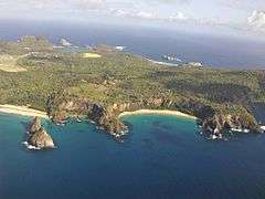 |
Pernambuco and Rio Grande do Norte 3°51′29″S 32°25′30″W / 3.85806°S 32.42500°W |
Natural: (vii)(ix)(x) |
42,270 (104,500) | 2001 | As one of the few insular habitats in the South Atlantic, the site is essential as feeding ground and reproduction space for marine organisms including endangered and threatened species, most notably the hawksbill sea turtle.[12] |
| Central Amazon Conservation Complex | 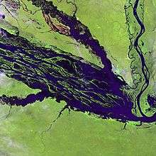 |
Amazonas 2°20′00″S 62°00′30″W / 2.33333°S 62.00833°W |
Natural: (ix)(x) |
5,323,018 (13,153,460) | 2000[nb 1] | As the largest protected area in the Amazon basin, the site is notable for its high biodiversity, range of habitats such as várzea and igapó forests and number of endangered species. It has been recognized by various conservation agencies as a high priority region.[nb 2][13] [14] |
| Cerrado Protected Areas: Chapada dos Veadeiros and Emas National Parks |  |
Goiás 14°00′20″S 47°41′05″W / 14.00556°S 47.68472°W |
Natural: (ix)(x) |
367,356 (907,760) | 2001 | The two parks are characteristic of the cerrado, one of the world's oldest tropical ecosystems and an important refuge for species in times of climate change.[15] |
| Discovery Coast Atlantic Forest Reserves |  |
Bahia and Espírito Santo 16°30′00″S 39°15′00″W / 16.50000°S 39.25000°W |
Natural: (ix)(x) |
111,930 (276,600) | 1999 | The site comprises some of the last remaining Atlantic Forests and shows a very high diversity with many rare and endemic species. As such it is of high interest both for scientists and for conservation.[16] |
| Historic Centre of Salvador de Bahia | 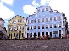 |
Bahia 12°58′00″S 38°30′00″W / 12.96667°S 38.50000°W |
Cultural: (iv)(vi) |
— | 1985 | The colonial old town of the first Brazilian capital and town of the first slave market in the New World, has preserved a large number of brightly colored Renaissance houses decorated with stucco work from the 16th to 18th centuries.[17] |
| Historic Centre of São Luís |  |
Maranhão 2°30′51″S 44°18′09″W / 2.51417°S 44.30250°W |
Cultural: (iii)(iv)(v) |
67 (170) | 1997 | São Luís has preserved the complete rectangular town plan and a large number of historical buildings making it a prime example of a Portuguese colonial town.[18] |
| Historic Centre of the Town of Diamantina | 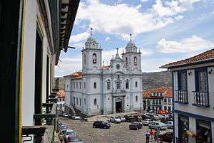 |
Minas Gerais 18°40′00″S 43°36′00″W / 18.66667°S 43.60000°W |
Cultural: (ii)(iv) |
29 (72) | 1999 | A well-preserved example of Baroque architecture, this 18th-century colonial town was founded in an inhospitable environment of rocky mountains and became a center of diamond mining in the 18th and 19th centuries.[19] |
| Historic Centre of the Town of Goiás | 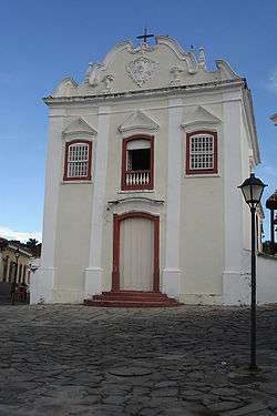 |
Goiás 15°56′00″S 50°08′00″W / 15.93333°S 50.13333°W |
Cultural: (ii)(iv) |
40 (99) | 2001 | Founded in 1727 by the bandeirante explorer Bartolomeu Bueno da Silva, Goiás has preserved much of its colonial heritage and is an example of a European settlement in the interior of South America.[20] |
| Historic Centre of the Town of Olinda | 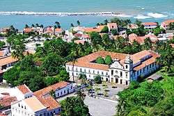 |
Pernambuco 8°00′48″S 34°50′42″W / 8.01333°S 34.84500°W |
Cultural: (ii)(iv) |
120 (300) | 1982 | Founded in 1537 the town prospered as a centre of sugar-cane production. Following looting by the Dutch in the 17th century, the historic centre dates largely to the 18th century with a harmonious combination of buildings, gardens, churches, convents and chapels.[21] |
| Historic Town of Ouro Preto | 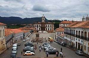 |
Minas Gerais 20°23′20″S 43°30′20″W / 20.38889°S 43.50556°W |
Cultural: (i)(iii) |
— | 1980 | The prosperity of the town as the center of the Brazilian gold rush in the 18th century is reflected in a large number of preserved churches, bridges and fountains many of them designed by the Baroque sculptor Aleijadinho.[22] |
| Iguaçu National Park | 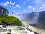 |
Paraná 25°41′00″S 54°26′00″W / 25.68333°S 54.43333°W |
Natural: (vii)(x) |
170,086 (420,290) | 1986 | Together with Iguazú National Park on the Argentinian side, the park protects Iguazu Falls, one of the world's largest waterfalls, and is home to many rare and endangered species such as giant anteater or the giant otter. The site had been listed as endangered 1999–2001 due to an illegally opened road through the park, dams on the Iguazu River and helicopter flights.[23] |
| Jesuit Missions of the Guaranis: San Ignacio Miní, Santa Ana, Nuestra Señora de Loreto and Santa María Mayor (Argentina), Ruins of São Miguel das Missões (Brazil) |  |
Rio Grande do Sul also Misiones Province, Argentina 28°32′36″S 54°15′57″W / 28.54333°S 54.26583°W |
Cultural: (iv) |
— | 1983[nb 3] | Each of the five ruined Spanish Jesuit missions founded amidst a tropical forest in the land of the Guaraní people in the 17th and 18th centuries is characterized by a specific design.[24] [25] |
| Pampulha Modern Ensemble | 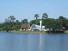 |
Minas Gerais 19°51′07″S 43°58′25″W / 19.85194°S 43.97361°W |
Cultural: (i)(ii)(iv) |
154 (380) | 2016 | The listed site consists of an urban project created in 1940 at Belo Horizonte, Minas Gerais. It was designed around an artificial lake, Lake Pampulha, and includes a casino, a ballroom, the Golf Yacht Club and the Church of Saint Francis of Assisi. The buildings were designed by the architect Oscar Niemeyer, in collaboration with the landscape architect Roberto Burle Marx and Brazilian Modernist artists.[6] |
| Pantanal Conservation Area | 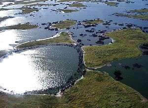 |
Mato Grosso and Mato Grosso do Sul 17°43′00″S 57°23′00″W / 17.71667°S 57.38333°W |
Natural: (vii)(ix)(x) |
187,818 (464,110) | 2000 | The site contains four protected areas, encompassing one of the world's largest freshwater wetland ecosystems, and is home to an abundant number and diverse range of species.[26] |
| Rio de Janeiro: Carioca Landscapes Between the Mountain and the Sea | 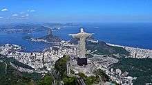 |
Rio de Janeiro 22°56′52″S 43°17′29″W / 22.94778°S 43.29139°W |
Cultural: (v)(vi) |
7,249 (17,910) | 2012 | The listed site consists of an exceptional urban setting rather than built heritage. It encompasses the key natural elements that have shaped and inspired the development of the city: from the highest points of the Tijuca National Park’s mountains down to the sea. They also include the Botanical Gardens, established in 1808, Corcovado Mountain with its celebrated statue of Christ and the hills around Guanabara Bay, including the extensive designed landscapes along Copacabana Bay which have contributed to the outdoor living culture of this spectacular city. Rio de Janeiro is also recognized for the artistic inspiration it has provided to musicians, landscapers and urbanists.[27] |
| Sanctuary of Bom Jesus do Congonhas |  |
Minas Gerais 20°29′59″S 43°51′28″W / 20.49972°S 43.85778°W |
Cultural: (i)(iv) |
— | 1985 | Built in the 18th century, the site features a church, an outdoor stairway and seven chapels, decorated with statues by Aleijadinho.[28] |
| São Francisco Square in the Town of São Cristóvão | _(6).jpg) |
Sergipe 11°00′58″S 37°12′36″W / 11.01611°S 37.21000°W |
Cultural: (ii)(iv) |
3 (7.4) | 2010 | The square is surrounded by two churches, a palace and other buildings of different historical periods, exemplifying Franciscan architecture in north-eastern Brazil.[29] |
| Serra da Capivara National Park | 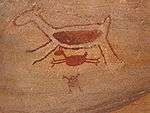 |
Piauí 8°25′00″S 42°20′00″W / 8.41667°S 42.33333°W |
Cultural: (iii) |
— | 1991 | The site is among the oldest human communities in South America, featuring a great number of cave paintings, some dating as early as 25,000 years ago.[30] |
Tentative List
In addition to sites inscribed on the World Heritage list, member states can maintain a list of tentative sites that they may consider for nomination. Nominations for the World Heritage list are only accepted if the site was previously listed on the tentative list.[31] As of 2016, Brazil lists twenty-four properties on its tentative list:[7]
- Réserve biologique d'Atol das Rocas (Rio Grande do Norte) (06/09/1996)
- Amazonia Theaters (Teatro Amazonas and Theatro da Paz) (30/01/2015)
- Anavilhanas Ecological Station (16/09/1998)
- Brazilian Fortresses Ensemble (30/01/2015)
- Canyon du Rio Peruaçu, Minas Gerais (11/03/1998)
- Cavernas do Peruaçu Federal Environmental Protection Area (APA) / Veredas Do Peruaçu State Park (16/09/1998)
- Cedro Dam in the Quixadá Monoliths Natural Monument (30/01/2015)
- Cultural Landscape of Paranapiacaba: Village and railway systems in the Serra do Mar Mountain Range, São Paulo (27/02/2014)
- Eglise et Monastère de São Bento, Rio de Janeiro (06/09/1996)
- Geoglyphs of Acre (30/01/2015)
- Gold Route in Parati and its landscape (08/01/2004)
- Palais de la Culture, ancien siège du Ministère de l'Education et de la Santé, Rio de Janeiro (06/09/1996)
- Parc national de la Serra da Bocaina (São Paulo - Rio de Janeiro) (06/09/1996)
- Itacoatiaras of Ingá River (30/01/2015)
- Parc national du Pico da Neblina (Amazonas) (06/09/1996)
- Serra da Canastra National Park (16/09/1998)
- Serra da Capivara National Park and Permanent Preservation Areas (16/09/1998)
- Serra do Divisor National Park (16/09/1998)
- Sítio Roberto Burle Marx (30/01/2015)
- Station écologique de Taim (Rio Grande do Sul) (06/09/1996)
- Station écologique du Raso da Catarina (Bahia) (06/09/1996)
- Valongo Wharf Archaeological Site (31/01/2014)
- Ver-o-Peso (27/02/2014)
Location of sites

Notes
- ↑ Extended in 2003 to include the Amana Sustainable Development Reserve, the Demonstration area of the Mamirauá Sustainable Development Reserve and the Anavilhanas Ecological Station; and name change from Jaú National Park, Brazil to the present name.
- ↑ It is a Centre of Plant Diversity, an Endemic Bird Area of the World and a Global 200 ecoregion.
- ↑ Extended in 1984 to include the four Argentinian missions making it a trans-border site; and name change from The Ruins of São Miguel das Missões to the present name.
References
- ↑ "The World Heritage Convention". UNESCO. Retrieved 21 September 2010.
- ↑ "Brazil". UNESCO. Retrieved 13 August 2016.
- ↑ "Report of the Rapporteur". UNESCO. 29 September 1980. Retrieved 12 July 2014.
- ↑ "Report of the 7th Session of the Committee". UNESCO. Retrieved 13 August 2016.
- ↑ "Report of the 10th Session of the Committee". UNESCO. Retrieved 13 August 2016.
- 1 2 "Pampulha Modern Ensemble". UNESCO. Retrieved 17 July 2016.
- 1 2 "Tentative List – Brazil". UNESCO. Retrieved 13 August 2016.
- ↑ "World Heritage List". UNESCO. Retrieved 28 May 2010.
- ↑ "The Criteria for Selection". UNESCO. Retrieved 10 September 2011.
- ↑ "Atlantic Forest South-East Reserves". UNESCO. Retrieved 28 May 2010.
- ↑ "Brasília". UNESCO. Retrieved 28 May 2010.
- ↑ "Brazilian Atlantic Islands: Fernando de Noronha and Atol das Rocas Reserves". UNESCO. Retrieved 28 May 2010.
- ↑ "Central Amazon Conservation Complex". UNESCO. Retrieved 28 May 2010.
- ↑ "Decision - 27COM 8C.10 - Central Amazon Conservation Complex (Brazil)". UNESCO. Retrieved 26 September 2011.
- ↑ "Cerrado Protected Areas: Chapada dos Veadeiros and Emas National Parks". UNESCO. Retrieved 28 May 2010.
- ↑ "Discovery Coast Atlantic Forest Reserves". UNESCO. Retrieved 28 May 2010.
- ↑ "Historic Centre of Salvador de Bahia". UNESCO. Retrieved 28 May 2010.
- ↑ "Historic Centre of São Luís". UNESCO. Retrieved 28 May 2010.
- ↑ "Historic Centre of the Town of Diamantina". UNESCO. Retrieved 28 May 2010.
- ↑ "Historic Centre of the Town of Goiás". UNESCO. Retrieved 10 September 2011.
- ↑ "Historic Centre of the Town of Olinda". UNESCO. Retrieved 10 September 2011.
- ↑ "Historic Town of Ouro Preto". UNESCO. Retrieved 10 September 2011.
- ↑ "Iguaçu National Park". UNESCO. Retrieved 10 September 2011.
- ↑ "Jesuit Missions of the Guaranis: San Ignacio Mini, Santa Ana, Nuestra Señora de Loreto and Santa Maria Mayor (Argentina), Ruins of Sao Miguel das Missoes (Brazil)". UNESCO. Retrieved 8 September 2011.
- ↑ "Jesuit Missions of the Guaranis". UNESCO. Retrieved 8 September 2011.
- ↑ "Pantanal Conservation Area". UNESCO. Retrieved 13 August 2016.
- ↑ "Rio de Janeiro: Carioca Landscapes between the Mountain and the Sea". UNESCO. Retrieved 2 July 2011.
- ↑ "Sanctuary of Bom Jesus do Congonhas". UNESCO. Retrieved 13 August 2016.
- ↑ "São Francisco Square in the Town of São Cristóvão". UNESCO. Retrieved 13 August 2016.
- ↑ "Serra da Capivara National Park". UNESCO. Retrieved 13 August 2016.
- ↑ "Tentative Lists". UNESCO. Retrieved 7 October 2010.
World Heritage Sites in Brazil | ||
|---|---|---|
| North Region | | |
| Northeast Region |
| |
| Central-West Region |
| |
| Southeast Region |
| |
| South Region |
| |
| North America | ||
|---|---|---|
| Central America and the Caribbean |
| |
| South America | ||