List of Scheduled Monuments in Torfaen
The county borough of Torfaen is in the south-east corner of Wales, occupying the valley of the Afon Llwyd, from Cwmbran and Pontypool up to Blaenavon. With only 2 prehistoric and 5 medieval scheduled sites, the list, like the landscape, is dominated by the Industrial monuments of the 18th and 19th centuries. In particular, the Blaenavon Industrial Landscape is a World Heritage Site.[1] Of the 25 monuments, 14 are found within the Blaenavon Community. All of the Torfaen administrative area lies within the historic county of Monmouthshire.
Scheduled Ancient Monuments (SAMs) have statutory protection. The compilation of the list is undertaken by Cadw Welsh Historic Monuments, which is an executive agency of the National Assembly of Wales.[2] The list of scheduled monuments below is supplied by Cadw[3] with additional material from RCAHMW and Glamorgan-Gwent Archaeological Trust.
Scheduled Monuments in Torfaen
| Image | Name | Site type | Community | Location | Details | Period | SAM No & Refs |
|---|---|---|---|---|---|---|---|
| Carn-y-Defaid Round Cairns | Round cairn | Blaenavon, (also Llanfoist Fawr), (see also Monmouthshire) |
51°47′03″N 3°03′31″W / 51.7842°N 3.0585°W, SO270100 |
Prehistoric |
MM209 [4] | ||
| Cairns (4) West of Craig y Dyffryn | Round cairn | Henllys | 51°37′43″N 3°05′01″W / 51.6285°N 3.0835°W, ST251927 |
Prehistoric |
MM045 [5] | ||
| Capel Newydd, Blaenavon (site of) | Chapel | Blaenavon | 51°45′47″N 3°03′33″W / 51.763°N 3.0592°W, SO269076 |
Medieval |
MM212 [6] | ||
| Llanderfel Church | Church | Fairwater | 51°39′06″N 3°03′55″W / 51.6516°N 3.0653°W, ST263953 |
Medieval |
MM271 [7] | ||
 |
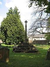
St. Peter's Churchyard Cross, Henllys | Cross | Henllys | 51°36′48″N 3°03′32″W / 51.6132°N 3.059°W, ST267910 |
Medieval |
MM309 [8] | |
| Llantarnam Churchyard Cross | Cross | Llantarnam | 51°37′58″N 3°00′10″W / 51.6328°N 3.0028°W, ST306931 |
Socket and shaft of a medieval cross, with modern steps and cross-head. | Medieval |
MM136 [9] | |
| Llantarnam Abbey Tithe Barn | Tithe barn | Llantarnam | 51°37′54″N 2°59′43″W / 51.6317°N 2.9954°W, ST312930 |
Long presumed to be an abbey building, this is now thought to be a 17th-century building | Medieval |
MM137 [10] | |
 |
Abersychan Limestone Railway | Railway | Abersychan | 51°43′57″N 3°03′07″W / 51.7324°N 3.0519°W, SO274042 |
Built c 1830 to carry limestone from Cwm Lascarn quarry to the British Ironworks. | Post Medieval/Modern |
GM597 [11] |
| Air Furnace at British Ironworks | Ironworks | Abersychan | 51°43′34″N 3°04′37″W / 51.7262°N 3.0769°W, SO257036 |
Rare remains of a reverbatory air furnace used for re-melting cast iron. The furnace is in the courtyard of the derelict foundry buildings. | Post-Medieval/Modern |
MM221 [12] | |
 |
British Colliery Pumping Engine House | Engine house | Abersychan | 51°43′36″N 3°04′30″W / 51.7266°N 3.0751°W, SO258036 |
Cornish beam pumping engine house built by the British Iron Company. Built of sandstone with a slate roof, and retains several fixtures. | Post-Medieval/Modern |
MM216 [13] |
 |
Cwmbyrgwm Colliery | Coal Mine | Abersychan | 51°43′25″N 3°05′09″W / 51.7236°N 3.0858°W, SO252033 |
Site of former colliery including remains of a water-balance headgear, chimney, oval shafts, water power dams, tramroad routes, and waste tips. | Post-Medieval/Modern |
MM163 [14] |
| Aaron Brute's Level and Iron Bridge |
Level | Blaenavon | 51°46′22″N 3°05′27″W / 51.7728°N 3.0909°W, SO248088 |
Post-Medieval/Modern |
MM220 [15] | ||
 |
Blaenavon Ironworks |
Industrial monument | Blaenavon | 51°46′37″N 3°05′21″W / 51.777°N 3.0892°W, SO249092 |
Post-Medieval/Modern |
MM200 [16] | |
| Blaenavon Upper Brick Yard |
Quarry | Blaenavon | 51°46′52″N 3°05′13″W / 51.781°N 3.087°W, SO251097 |
Also known as Bunker Hill Brick Yard. | Post-Medieval/Modern |
MM296 [17] | |
| Brake Engine on Hill Pits Tramroad Incline |
Industrial monument | Blaenavon | 51°46′57″N 3°05′56″W / 51.7826°N 3.099°W, SO242098 |
Post-Medieval/Modern |
MM222 [18] | ||
| Coal and Iron Ore Workings West of Abergavenny Road, Blaenavon |
Iron mine | Blaenavon | 51°47′13″N 3°05′02″W / 51.7869°N 3.084°W, SO253103 |
Post-Medieval/Modern |
MM297 [19] | ||
| Coity Sandstone Quarry and Incline |
Quarry | Blaenavon | 51°46′12″N 3°06′37″W / 51.7699°N 3.1102°W, SO234084 |
Post-Medieval/Modern |
MM279 [20] | ||
 |
Dyne Steel Incline |
Incline | Blaenavon, (also Llanfoist Fawr), (see also Monmouthshire) |
51°47′36″N 3°06′06″W / 51.7933°N 3.1017°W, SO241110 |
Post-Medieval/Modern |
MM280 [21] | |
| Engine Pit, Blaenavon |
Coal Mine | Blaenavon | 51°46′29″N 3°05′50″W / 51.7747°N 3.0972°W, SO243090 |
Earliest Blaenafon shaft coalmine, sunk in 1806 | Post-Medieval/Modern |
MM277 [22] | |
 |
Iron and coal patching at Pen-ffordd-goch (Keeper's Pond), Blaenavon |
Industrial monument | Blaenavon, (also Llanfoist Fawr), (see also Monmouthshire) |
51°47′18″N 3°04′38″W / 51.7882°N 3.0773°W, SO257104 |
Post-Medieval/Modern |
MM227 [23] | |
| Ironstone Quarries at Carreg Maen Taro |
Quarry | Blaenavon, (also Llanfoist Fawr and Llanelly), (see also Monmouthshire) |
51°47′38″N 3°06′20″W / 51.794°N 3.1056°W, SO238111 |
Post-Medieval/Modern |
MM295 [24] | ||
| Old Coal Pits, Blaenavon |
Air Shaft | Blaenavon | 51°46′46″N 3°05′51″W / 51.7795°N 3.0974°W, SO243095 |
Post-Medieval/Modern |
MM293 [25] | ||
_(4887928056)_(3).jpg) |
Pwll Du Tramroad Tunnel Southern Approach |
Industrial monument | Blaenavon | 51°46′53″N 3°05′26″W / 51.7814°N 3.0905°W, SO248096 |
Post-Medieval/Modern |
MM223 [26] | |
| Iron Ore Scours at Upper Race, Pontypool | Industrial monument | Pontymoile | 51°40′53″N 3°02′55″W / 51.6815°N 3.0486°W, ST276986 |
Post-Medieval/Modern |
MM256 [27] | ||
| Old Beam Pump & Winding Engine, Glyn Pits | Industrial building | Pontymoile | 51°41′33″N 3°03′50″W / 51.6924°N 3.0638°W, ST265998 |
Post-Medieval/Modern |
MM192 [28] | ||

See also
- List of Cadw properties
- List of castles in Wales
- List of hill forts in Wales
- Historic houses in Wales
- List of monastic houses in Wales
- List of museums in Wales
- List of Roman villas in Wales
- Grade I listed buildings in Torfaen
- Grade II* listed buildings in Torfaen
References
- Coflein is the online database of RCAHMW: Royal Commission on the Ancient and Historical Monuments of Wales, GGAT is the Glamorgan-Gwent Archaeological Trust, Cadw is the Welsh Historic Monuments Agency
- 1 2 Blaenafon Industrial Landscape
- ↑ Cadw: Ancient Monuments and Scheduling. Accessed 25 April 2013
- ↑ Cadw will send their list as a spreadsheet, or other electronic formats, on request, as indicated at www.whatdotheyknow.com. This list uses information dated May 2012
- ↑ coflein NPRN: 306237 South cairn, coflein NPRN: 306238 North cairn. GGAT PRN: 08442g. Cadw SAM: MM209: Carn-y-Defaid Round Cairns
- ↑ coflein NPRN: 307841. coflein NPRN: 307842. coflein NPRN: 307843. coflein NPRN: 307844. GGAT PRN: 00138g, GGAT PRN: 00139g, GGAT PRN: 00140g, GGAT PRN: 00141g. Cadw SAM: MM045: Cairns West of Craig y Dyffryn
- ↑ coflein NPRN: 300133. GGAT PRN: 02079g. Cadw SAM: MM212: Capel Newydd, Blaenavon (site of)
- ↑ coflein NPRN: 307835. GGAT PRN: 0106g. Cadw SAM: MM271: Llanderfel Church
- ↑ coflein NPRN: 307834. GGAT PRN: 00151g. Cadw SAM: MM309: St. Peter's Churchyard Cross, Henllys
- ↑ coflein NPRN: 307897. GGAT PRN: 00623g. Cadw SAM: MM136: Churchyard Cross
- ↑ coflein NPRN: 43276. GGAT PRN: 00627g. Cadw SAM: MM137: Llantarnam Abbey Tithe Barn
- ↑ coflein NPRN: 407507. GGAT PRN: 07226g. Cadw SAM: GM597: Abersychan Railway
- ↑ coflein NPRN: 85068. GGAT PRN: 04698g. Cadw SAM: MM221: Air Furnace at British Ironworks
- ↑ coflein NPRN: 85065. GGAT PRN: 04699g. Cadw SAM: MM216: British Colliery Pumping Engine House
- ↑ coflein NPRN: 85072. GGAT PRN: 02156g. Cadw SAM: MM163: Cwmbyrgwm Colliery
- ↑ Level coflein NPRN: 307044. GGAT PRN: 03319g. Bridge coflein NPRN: 307044. GGAT PRN: 03319g. Cadw SAM: MM220: Aaron Brute's Level and Iron Bridge
- ↑ coflein NPRN: 34134. GGAT PRN: 02221g. Cadw SAM: MM200: Blaenavon Ironworks
- ↑ coflein NPRN: 260702. GGAT PRN: 08117g. Cadw SAM: MM296: Blaenavon Upper Brick Yard
- ↑ coflein NPRN: 88059. GGAT PRN: 04694g. Cadw SAM: MM222: Brake Engine on Hill Pits Tramroad Incline
- ↑ coflein NPRN: 304095. GGAT PRN: 05529g. Cadw SAM: MM297: Coal and Iron Ore Workings West of Abergavenny Road, Blaenavon
- ↑ coflein NPRN: 276010. GGAT PRN: 03439g. Cadw SAM: MM279: Coity Sandstone Quarry and Incline
- ↑ coflein NPRN: 260302. GGAT PRN: 05493.0g. Cadw SAM: MM280: Dyne Steel Incline
- ↑ coflein NPRN: 67650. GGAT PRN: 03321g. Cadw SAM: MM277: Engine Pit, Blaenavon
- ↑ coflein NPRN: 308295. GGAT PRN: 00056g. Cadw SAM: MM227: Iron and coal patching at Pen-ffordd-goch, Blaenavon
- ↑ coflein NPRN: 260542. GGAT PRN: 03552g. Cadw SAM: MM295: Ironstone Quarries at Carreg Maen Taro
- ↑ coflein NPRN: 276020. GGAT PRN: 07826g. Cadw SAM: MM293: Old Coal Pits, Blaenavon
- ↑ coflein NPRN: 85831. GGAT PRN: 04692.0g. Cadw SAM: MM223: Pwll Du Tramroad Tunnel Southern Approach
- ↑ coflein NPRN: 302570. GGAT PRN: 0797g. Cadw SAM: MM256: Iron Ore Scours at Upper Race, Pontypool
- ↑ coflein NPRN: 33566. GGAT PRN: 02335g. Cadw SAM: MM192: Old Beam Pump & Winding Engine, Glyn Pits