List of Scheduled Monuments in Caerphilly
Caerphilly County Borough straddles the boundary of the historic counties of Glamorgan and Monmouthshire in South Wales. The 46 Scheduled monuments include burial cairns from the Bronze Age, an Iron Age hillfort, and Roman camps. The medieval sites include 2 castles and a further 4 mottes as well as dwellings, crosses and churches. Finally the post-medieval sites include the blast furnaces and ironworks of the industrial period.
Scheduled Ancient Monuments (SAMs) have statutory protection. The compilation of the list is undertaken by Cadw Welsh Historic Monuments, which is an executive agency of the National Assembly of Wales.[1] The list of scheduled monuments below is supplied by Cadw[2] with additional material from RCAHMW and Glamorgan-Gwent Archaeological Trust.
Scheduled Monuments in Caerphilly
| Image | Name | Site type | Community | Location | Details | Historic County | Period | SAM No & Refs |
|---|---|---|---|---|---|---|---|---|
| Cairnfield on Mynydd Eglwysilan | Round cairn | Aber Valley | 51°37′20″N 3°16′45″W / 51.6223°N 3.2792°W, ST115922 |
Glamorganshire | Prehistoric |
GM352 [3] | ||
| Garnedd Lwyd | Round cairn | Aber Valley | 51°36′18″N 3°17′25″W / 51.6051°N 3.2904°W, ST107903 |
Glamorganshire | Prehistoric |
GM462 [4] | ||
| Two Round Cairns on the Bryn | Round cairn | Aber Valley | 51°36′35″N 3°14′52″W / 51.6096°N 3.2479°W, ST136908 |
Glamorganshire | Prehistoric |
GM463 [5] | ||
| Begwns Round Barrow, Mynydd Machen | Round cairn | Bedwas, Trethomas and Machen | 51°36′13″N 3°07′20″W / 51.6036°N 3.1222°W, ST223900 |
Monmouthshire | Prehistoric |
MM071 [6] | ||
| Cairn 270m N of Pont Ffosyrhebog | Round cairn | Darran Valley | 51°43′00″N 3°17′09″W / 51.7168°N 3.2857°W, SO112027 |
Glamorganshire | Prehistoric |
GM313 [7] | ||
.jpg) |
Maen Cattwg (cup-marked stone) | Cup-marked stone | Gelligaer | 51°40′08″N 3°15′50″W / 51.6689°N 3.2638°W, ST126974 |
Glamorganshire | Prehistoric |
GM176 [8] | |
| Bryn Owen Farm Cairns, Llanfabon | Round cairn | Llanbradach | 51°36′35″N 3°14′16″W / 51.6096°N 3.2378°W, ST143908 |
Glamorganshire | Prehistoric |
GM051 [9] | ||
| Cairn Cemetery on Mynydd Bach, Bedwas | Round cairn | Maesycwmmer | 51°37′14″N 3°12′09″W / 51.6206°N 3.2025°W, ST168919 |
Monmouthshire | Prehistoric |
MM196 [10] | ||
| Pen-y-Rhiw Round Cairn | Round cairn | Maesycwmmer | 51°37′13″N 3°12′12″W / 51.6204°N 3.2033°W, ST167919 |
Monmouthshire | Prehistoric |
MM149 [11] | ||
| Carneddi Llwydion | Round cairn | Nelson | 51°37′11″N 3°17′38″W / 51.6198°N 3.294°W, ST105920 |
Glamorganshire | Prehistoric |
GM302 [12] | ||
| Round Cairn 315m S of Upper Wenallt | Round cairn | Risca | 51°36′32″N 3°04′31″W / 51.609°N 3.0754°W, ST256905 |
Monmouthshire | Prehistoric |
MM046 [13] | ||
| Twyn Cae-Hugh Round Barrow | Round barrow | Ynysddu | 51°36′59″N 3°11′41″W / 51.6163°N 3.1947°W, ST173915 |
Monmouthshire | Prehistoric |
MM033 [14] | ||
| Twyn-Yr-Oerfel Round Barrows | Round barrow | Ynysddu | 51°36′33″N 3°11′02″W / 51.6091°N 3.1839°W, ST181906 |
Monmouthshire | Prehistoric |
MM070 [15] | ||
 |
Ruperra Hillfort and Motte | Hillfort | Rudry | 51°34′24″N 3°07′23″W / 51.5733°N 3.1231°W, ST222866 |
Glamorganshire | Prehistoric |
GM511 [16] | |
| Cefn Manmoel cross-ridge dyke | Cross Ridge Dyke | Argoed, (also Cwm, Blaenau Gwent) | 51°44′39″N 3°12′06″W / 51.7442°N 3.2018°W, SO171057 |
Linear defensive earthwork which may be from neolithic or medieval period. This site crosses the border into Blaenau Gwent | Monmouthshire | Unknown |
MM345 [17] | |
| Rectangular Earthworks 530m SSW of Heol-Ddu-Uchaf | Practice camp | Bargoed | 51°41′04″N 3°14′52″W / 51.6845°N 3.2477°W, ST138991 |
Glamorganshire | Roman |
GM164 [18] | ||
| Fforest Gwladys Roman practice camp | Practice camp | Gelligaer | 51°41′02″N 3°15′28″W / 51.6838°N 3.2579°W, ST131990 |
Glamorganshire | Roman |
GM273 [19] | ||
.jpg) |
Gelligaer Roman Site | Fort | Gelligaer | 51°40′01″N 3°15′17″W / 51.667°N 3.2548°W, ST133972 |
Glamorganshire | Roman |
GM016 [20] | |
| Fort South of Pen-Llwyn-Fawr | Fort | Pontllanfraith | 51°39′04″N 3°11′42″W / 51.651°N 3.195°W, ST174953 |
Monmouthshire | Roman |
MM096 [21] | ||
| Cross Ridge Dyke & Cairn on Twyn Hywel | Cross Ridge Dyke | Aber Valley, (also Pontypridd) | 51°36′42″N 3°18′03″W / 51.6116°N 3.3007°W, ST100911 |
(The dyke crosses the border into Rhondda Cynon Taf) | Glamorganshire | Unknown |
GM456 [22] | |
 |
Capel Gwladys | Chapel | Darran Valley | 51°41′08″N 3°16′02″W / 51.6856°N 3.2671°W, ST125992 |
Glamorganshire | Early Medieval |
GM309 [23] | |
| Dyke 387m E of Clawdd Trawscae Farm | Ditch | Darran Valley | 51°41′40″N 3°16′41″W / 51.6944°N 3.278°W, SO117002 |
Glamorganshire | Early Medieval |
GM261 [24] | ||
| Site of Tegernacus Stone | Inscribed stone | Darran Valley | 51°42′57″N 3°14′59″W / 51.7157°N 3.2498°W, SO137026 |
Glamorganshire | Early Medieval |
GM339 [25] | ||
 |
St. Sannan's Churchyard Cross, Bedwellty | Cross | Argoed | 51°41′42″N 3°12′27″W / 51.6951°N 3.2074°W, SO166002 |
Monmouthshire | Medieval |
MM310 [26] | |
.jpg) |
Bedwas Churchyard Cross | Cross | Bedwas, Trethomas and Machen | 51°35′43″N 3°11′53″W / 51.5954°N 3.1981°W, ST171891 |
Monmouthshire | Medieval |
MM143 [27] | |
| House Platforms to W of Mynydd Machen | House platform | Bedwas, Trethomas and Machen | 51°36′15″N 3°07′30″W / 51.6043°N 3.1249°W, ST221900 |
Monmouthshire | Medieval |
MM337 [28] | ||
 |
Caerphilly Castle |
Castle | Caerphilly | 51°34′35″N 3°13′14″W / 51.5763°N 3.2206°W, ST155870 |
Glamorganshire | Medieval |
GM002 [29] | |
 |
Castell Morgraig | Castle | Caerphilly, (also Lisvane) | 51°33′07″N 3°12′47″W / 51.5519°N 3.213°W, ST159843 |
(Site is on the border with Cardiff) | Glamorganshire | Medieval |
GM031 [30] |
 |
Capel y Brithdir | Chapel | Darran Valley | 51°42′54″N 3°14′53″W / 51.7149°N 3.2481°W, SO138025 |
Glamorganshire | Medieval |
GM451 [31] | |
| Platform Houses on East Side of Gelligaer Common | Platform house | Darran Valley | 51°42′59″N 3°16′50″W / 51.7164°N 3.2806°W, SO116027 |
Glamorganshire | Medieval |
GM311 [32] | ||
| Three Platform Houses on Cefn Brithdir | Platform house | Darran Valley | 51°43′09″N 3°15′44″W / 51.7193°N 3.2623°W, SO128030 |
Glamorganshire | Medieval |
GM317 [33] | ||
| Twyn Castell | Motte | Gelligaer | 51°39′53″N 3°14′59″W / 51.6646°N 3.2496°W, ST136969 |
Glamorganshire | Medieval |
GM121 [34] | ||
 |
Twmbarlwm Mound and Bailey Castle | Motte | Risca | 51°37′38″N 3°05′46″W / 51.6272°N 3.0961°W, ST243926 |
Monmouthshire | Medieval |
MM044 [35] | |
| Gwern-y-Domen Castle Mound | Motte | Van | 51°35′01″N 3°11′31″W / 51.5837°N 3.192°W, ST175878 |
Glamorganshire | Medieval |
GM218 [36] | ||
 |
Twyn Tudor | Motte | Ynysddu | 51°38′14″N 3°10′01″W / 51.6373°N 3.1669°W, ST193938 |
Monmouthshire | Medieval |
MM035 [37] | |
| Charcoal Blast Furnace at Abercarn | Blast Furnace | Abercarn | 51°38′50″N 3°08′03″W / 51.6471°N 3.1342°W, ST216948 |
Monmouthshire | Post-Medieval/Modern |
MM250 [38] | ||
| Cornish Type Engine House, Bryngwyn Colliery | Engine house | Bedwas, Trethomas and Machen | 51°35′46″N 3°12′40″W / 51.5962°N 3.2111°W, ST162892 |
Glamorganshire | Post-Medieval/Modern |
GM440 [39] | ||
| Machen Forge and Tinplate Works | Water Power System | Bedwas, Trethomas and Machen | 51°35′35″N 3°09′04″W / 51.593°N 3.1511°W, ST203888 |
Glamorganshire | Post-Medieval/Modern |
GM516 [40] | ||
| Caerffili Mountain Shaft Mounds | Shaft Mounds | Caerphilly | 51°33′30″N 3°13′22″W / 51.5583°N 3.2229°W, ST153850 |
Glamorganshire | Post-Medieval/Modern |
GM454 [41] | ||
| Former Dam of Cwmcarn Canal Reservoir | Dam | Crosskeys | 51°38′07″N 3°07′30″W / 51.6353°N 3.1249°W, ST222935 |
Monmouthshire | Post-Medieval/Modern |
MM259 [42] | ||
 |
Pen-y-fan Pond | Reservoir | Crumlin | 51°41′52″N 3°09′51″W / 51.6979°N 3.1641°W, SO196005 |
Canal Reservoir | Monmouthshire | Post-Medieval/Modern |
MM269 [43] |
| Caerphilly Iron Furnace | Ironworks | Penyrheol,Trecenydd and Energlyn | 51°34′53″N 3°14′22″W / 51.5815°N 3.2394°W, ST142876 |
Glamorganshire | Post-Medieval/Modern |
GM503 [44] | ||
_(geograph_2895600).jpg) |
Rhymney Upper Furnace | Blast Furnace | Rhymney | 51°46′27″N 3°17′36″W / 51.7741°N 3.2934°W, SO108091 |
Glamorganshire | Post-Medieval/Modern |
GM403 [45] | |
| Rudry Ironworks | Ironworks | Rudry | 51°35′14″N 3°09′44″W / 51.5873°N 3.1622°W, ST195882 |
Glamorganshire | Post-Medieval/Modern |
GM357 [46] | ||
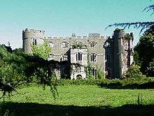 |
Ruperra Castle | House (domestic) | Rudry | 51°34′13″N 3°07′38″W / 51.5703°N 3.1271°W, ST219863 |
Glamorganshire | Post-Medieval/Modern |
GM379 [47] | |
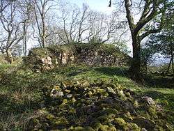
.jpg) |
Ruperra Castle lower summerhouse remains | Garden building | Rudry | 51°34′22″N 3°07′20″W / 51.5729°N 3.1221°W, ST223866 |
Glamorganshire | Post-Medieval/Modern |
GM590 [48] |
See also
- List of Cadw properties
- List of castles in Wales
- List of hill forts in Wales
- Historic houses in Wales
- List of monastic houses in Wales
- List of museums in Wales
- List of Roman villas in Wales
- Grade I listed buildings in Caerphilly
- Grade II* listed buildings in Caerphilly
References
- Coflein is the online database of RCAHMW: Royal Commission on the Ancient and Historical Monuments of Wales, GGAT is the Glamorgan-Gwent Archaeological Trust, Cadw is the Welsh Historic Monuments Agency
- ↑ Cadw: Ancient Monuments and Scheduling. Accessed 25 April 2013
- ↑ Cadw will send their list as a spreadsheet, or other electronic formats, on request, as indicated at www.whatdotheyknow.com. This list uses information dated May 2012
- ↑ coflein NPRN: not yet identified. GGAT PRN not yet identified. Cadw SAM: GM352: Cairnfield on Mynydd Eglwysilan
- ↑ coflein NPRN: 95600. GGAT PRN not yet identified. Cadw SAM: GM462: Garnedd Lwyd
- ↑ coflein NPRN: not yet identified. GGAT PRN not yet identified. Cadw SAM: GM463: Two Round Cairns on the Bryn
- ↑ coflein NPRN: not yet identified. GGAT PRN not yet identified. Cadw SAM: MM071: Begwns Round Barrow, Mynydd Machen
- ↑ coflein NPRN: not yet identified. GGAT PRN not yet identified. Cadw SAM: GM313: Cairn 270m N of Pont Ffosyrhebog
- ↑ coflein NPRN: 93097. GGAT PRN: 00655m. Cadw SAM: GM176: Maen Cattwg (cup-marked stone)
- ↑ coflein NPRN: not yet identified. GGAT PRN not yet identified. Cadw SAM: GM051: Bryn Owen Farm Cairns, Llanfabon
- ↑ coflein NPRN: not yet identified. GGAT PRN not yet identified. Cadw SAM: MM196: Cairn Cemetery on Mynydd Bach, Bedwas
- ↑ coflein NPRN: not yet identified. GGAT PRN not yet identified. Cadw SAM: MM149: Pen-y-Rhiw Round Cairn
- ↑ coflein NPRN: not yet identified. GGAT PRN not yet identified. Cadw SAM: GM302: Carneddi Llwydion
- ↑ coflein NPRN: not yet identified. GGAT PRN not yet identified. Cadw SAM: MM046: Round Cairn 315m S of Upper Wenallt
- ↑ coflein NPRN: not yet identified. GGAT PRN not yet identified. Cadw SAM: MM033: Twyn Cae-Hugh Round Barrow
- ↑ coflein NPRN: not yet identified. GGAT PRN not yet identified. Cadw SAM: MM070: Twyn-Yr-Oerfel Round Barrows
- ↑ coflein NPRN: 226513. GGAT PRN not yet identified. Cadw SAM: GM511: Ruperra Hillfort and Motte
- ↑ coflein NPRN: 407565. GGAT PRN: 08677g. Cadw SAM: MM345: Cefn Man Moel Cross-Ridge Dyke
- ↑ coflein NPRN: not yet identified. GGAT PRN not yet identified. Cadw SAM: GM164: Rectangular Earthworks 530m SSW of Heol-Ddu-Uchaf
- ↑ coflein NPRN: not yet identified. GGAT PRN not yet identified. Cadw SAM: GM273: Fforest Gwladys Roman practice camp
- ↑ coflein NPRN: 300144. GGAT PRN: 01132m. Cadw SAM: GM016: Gelligaer Roman Site
- ↑ coflein NPRN: not yet identified. GGAT PRN not yet identified. Cadw SAM: MM096: Fort South of Pen-Llwyn-Fawr
- ↑ coflein NPRN: not yet identified. GGAT PRN not yet identified. Cadw SAM: GM456: Cross Ridge Dyke & Cairn on Twyn Hywel
- ↑ coflein NPRN: 95694. GGAT PRN: 00649m. Cadw SAM: GM309: Capel Gwladys
- ↑ coflein NPRN: not yet identified. GGAT PRN not yet identified. Cadw SAM: GM261: Dyke 387m E of Clawdd Trawscae Farm
- ↑ coflein NPRN: 301357. GGAT PRN not yet identified. Cadw SAM: GM339: Site of Tegernacus Stone
- ↑ coflein NPRN: not yet identified. GGAT PRN not yet identified. Cadw SAM: MM310: St. Sannan's Churchayrd Cross, Bedwellty
- ↑ coflein NPRN: 307788. GGAT PRN not yet identified. Cadw SAM: MM143: Bedwas Churchyard Cross
- ↑ coflein NPRN: not yet identified. GGAT PRN not yet identified. Cadw SAM: MM337: House Platforms to W of Mynydd Machen
- ↑ coflein NPRN: 94497. GGAT PRN not yet identified. Cadw SAM: GM002: Caerphilly Castle
- ↑ coflein NPRN: 94525. GGAT PRN not yet identified. Cadw SAM: GM031: Castell Morgraig
- ↑ coflein NPRN: 307533. GGAT PRN: 02420m. Cadw SAM: GM451: Capel y Brithdir
- ↑ coflein NPRN: not yet identified. GGAT PRN not yet identified. Cadw SAM: GM311: Platform Houses on East Side of Gelligaer Common
- ↑ coflein NPRN: not yet identified. GGAT PRN not yet identified. Cadw SAM: GM317: Three Platform Houses on Cefn Brithdir
- ↑ coflein NPRN: 93071. GGAT PRN not yet identified. Cadw SAM: GM121: Twyn Castell
- ↑ coflein NPRN: 268157. GGAT PRN not yet identified. Cadw SAM: MM044: Twm-Barlwm Mound and Bailey Castle
- ↑ coflein NPRN: 307787. GGAT PRN not yet identified. Cadw SAM: GM218: Gwern-y-Domen Castle Mound
- ↑ coflein NPRN: not yet identified. GGAT PRN not yet identified. Cadw SAM: MM035: Twyn Tudor
- ↑ coflein NPRN: not yet identified. GGAT PRN: 04874g. Cadw SAM: MM250: Charcoal Blast Furnace at Abercarn
- ↑ coflein NPRN: not yet identified. GGAT PRN not yet identified. Cadw SAM: GM440: Cornish Type Engine House, Bryngwyn Colliery
- ↑ coflein NPRN: not yet identified. GGAT PRN not yet identified. Cadw SAM: GM516: Machen Forge and Tinplate Works
- ↑ coflein NPRN: not yet identified. GGAT PRN not yet identified. Cadw SAM: GM454: Caerffili Mountain Shaft Mounds
- ↑ coflein NPRN: not yet identified. GGAT PRN not yet identified. Cadw SAM: MM259: Former Dam of Cwmcarn Canal Reservoir
- ↑ coflein NPRN: 276005. GGAT PRN: 7649g. Cadw SAM: MM269: Pen y Fan Canal Reservoir
- ↑ coflein NPRN: not yet identified. GGAT PRN not yet identified. Cadw SAM: GM503: Caerphilly Iron Furnace
- ↑ coflein NPRN: 80451. GGAT PRN: 01083m. Cadw SAM: GM403: Rhymney Upper Furnace
- ↑ coflein NPRN: 34118. GGAT PRN: 00965m. Cadw SAM: GM357: Rudry Ironworks
- ↑ coflein NPRN: 19900. GGAT PRN: 02451m. Cadw SAM: GM379: Ruperra Castle
- ↑ coflein NPRN: 405144. GGAT PRN: 01672m. Cadw SAM: GM590: Ruperra Castle lower summerhouse remains