National Register of Historic Places listings in Mendocino County, California
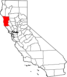
Location of Mendocino County in California
This is a list of the National Register of Historic Places listings in Mendocino County, California.
This is intended to be a complete list of the properties and districts on the National Register of Historic Places in Mendocino County, California, United States. Latitude and longitude coordinates are provided for many National Register properties and districts; these locations may be seen together in a Google map.[1]
There are 42 properties and districts listed on the National Register in the county, including 1 National Historic Landmark.
- This National Park Service list is complete through NPS recent listings posted December 16, 2016.[2]
Current listings
| [3] | Name on the Register[4] | Image | Date listed[5] | Location | City or town | Description |
|---|---|---|---|---|---|---|
| 1 | Arena Cove Historic District | 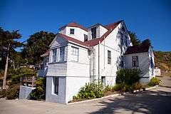 |
(#90001363) |
Arena Cove 38°54′54″N 123°42′28″W / 38.915°N 123.707778°W |
Point Arena | |
| 2 | Dr. Raymond Babcock House | Upload image | (#04000620) |
96 S. Humboldt St. 39°24′45″N 123°21′07″W / 39.4125°N 123.351944°W |
Willits | |
| 3 | Buckridge Ranch House | Upload image | (#90001359) |
On the Garcia River near Buckridge Rd. 38°55′35″N 123°37′33″W / 38.926389°N 123.625833°W |
Point Arena | |
| 4 | Con Creek School | 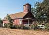 |
(#79000498) |
2 miles (3.2 km) north of Boonville on State Route 128 39°01′47″N 123°23′07″W / 39.029722°N 123.385278°W |
Boonville | Also known as the Little Red Schoolhouse, the Con Creek School is a schoolhouse built in the Greek Revival style by J.D. Ball in 1891. Used as a classroom for eight grade levels for 50 years, it was trimmed down to only 7th and 8th grades by 1941. In 1958 its use changed again to that of a kindergarten, and remained so until 1979, when it was donated to the local historical society. The Little Red Schoolhouse is located near the community of Boonville[6] |
| 5 | Jerome B. Ford House |  |
(#10000394) |
735 Main St. 39°18′19″N 123°47′50″W / 39.305278°N 123.797222°W |
Mendocino | |
| 6 | FROLIC (brig) | Upload image | (#91000565) |
Northeast of Pt. Cabrillo 39°21′18″N 123°49′15″W / 39.355°N 123.820833°W |
Caspar | |
| 7 | O. W. Getchell House |  |
(#80000819) |
State Route 1 38°47′48″N 123°34′05″W / 38.796667°N 123.568056°W |
Anchor Bay | Located in the community of Anchor Bay, the Getchell house was built by Osgood W. Getchel c.1870. A prominent location on a bluff and near a trade route established the Getchell house as a popular landmark for both land and sea travelers. The Getchell house was also one of the only wood structures to survive the 1906 earthquake.[7] |
| 8 | E. P. and Clara Gillmore House | 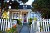 |
(#90001355) |
40 Mill St. 38°55′04″N 123°41′25″W / 38.917778°N 123.690278°W |
Point Arena | The Gillmore house is one of the few houses in Point Arena that was designed in an architectural style, specifically Second Empire. Built in the 1870s, the house was the residence of E.P. Gillmore, a one time county supervisor and the owner of a local livery stable and general store.[8] |
| 9 | Sid Groshon House | 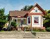 |
(#90001356) |
50 Mill St. 38°54′32″N 123°41′24″W / 38.908889°N 123.69°W |
Point Arena | A small Victorian cottage, and the only Queen Anne style home in Point Arena.[9] |
| 10 | Held-Poage House |  |
(#87002292) |
603 W. Perkins St. 39°08′55″N 123°12′40″W / 39.148611°N 123.211111°W |
Ukiah | A Queen Anne Victorian house located near downtown Ukiah, the building was the home of William D.L. and Ethel Poage Held, who took residence in 1903. William D.L. Held numerous positions in public service, including serving in the California State Legislature and as the Mayor of the City of Ukiah. In 1969, the building was donated to the Mendocino County Historical Society by William P. Held[10] and now serves as a research library.[11] |
| 11 | Charles Hofman House | 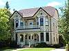 |
(#93001022) |
308 S. School St. 39°08′54″N 123°12′26″W / 39.148333°N 123.207222°W |
Ukiah | A Stick-Eastlake style Victorian home that sits just blocks south of the Mendocino County courthouse in downtown Ukiah.[12] |
| 12 | Hoyt-Scott House | 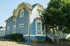 |
(#90001354) |
10 Riverside Dr. 38°54′40″N 123°41′28″W / 38.911111°N 123.691111°W |
Point Arena | |
| 13 | Italian Hotel |  |
(#90001361) |
105 Main St. 38°54′25″N 123°42′08″W / 38.906944°N 123.702222°W |
Point Arena | A Classical Revival style home built in the early 19th century for the owner of local brewery. The Italian Hotel has the dubious distinction of being used as a brothel in the small red-light district of Point Arena during World War II.[13] |
| 14 | Iverson House | 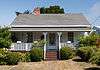 |
(#90001353) |
40 Iverson Ave. 38°54′29″N 123°41′33″W / 38.908056°N 123.6925°W |
Point Arena | A small Greek Revival style house build in Point Arena in 1875 for the local Iverson family.[14] |
| 15 | Billy Ketchum House | 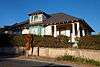 |
(#90001358) |
10 Scott Pl. 38°54′42″N 123°41′28″W / 38.911667°N 123.691111°W |
Point Arena | A bungalow/Craftsman home built for the local manager of the Point Arena Hot Springs in the early 20th century.[15] |
| 16 | Larsen Family House | Upload image | (#95001153) |
84 State St. 39°24′49″N 123°21′09″W / 39.413611°N 123.3525°W |
Willits | |
| 17 | Lovejoy Homestead | Upload image | (#78000719) |
North of Branscomb 39°44′52″N 123°38′00″W / 39.747778°N 123.633333°W |
Branscomb | |
| 18 | Main Street Historic Commercial District | 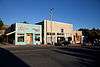 |
(#90001364) |
165-265 Main St. 38°54′35″N 123°41′29″W / 38.909722°N 123.691389°W |
Point Arena | Thirty buildings on either side of California State Highway 1 in Point Arena.[16] |
| 19 | Manchester Schoolhouse | Upload image | (#79000499) |
19750 State Route 1 38°58′01″N 123°41′10″W / 38.966944°N 123.686111°W |
Manchester | |
| 20 | Mendocino and Headlands Historic District | 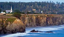 |
(#71000165) |
Bounded roughly by the Pacific Ocean on the west and south, Little Lake St. on the north, and State Route 1 on the east 39°18′30″N 123°48′23″W / 39.308333°N 123.806389°W |
Mendocino | |
| 21 | Mendocino Woodlands Recreational Demonstration Area | Upload image | (#97001262) |
11301 Little Lake Rd. 39°19′39″N 123°41′54″W / 39.3275°N 123.698333°W |
Mendocino | |
| 22 | Milano Hotel | Upload image | (#78000720) |
38300 State Route 1, S. 38°46′40″N 123°32′27″W / 38.777778°N 123.540833°W |
Gualala | |
| 23 | LeGrand Morse House | Upload image | (#90001362) |
365 Main St. 38°54′50″N 123°41′28″W / 38.913889°N 123.691111°W |
Point Arena | A Classical Revival style house build c.1870 for LeGrand Morse, a local teacher, clerk, lawyer and legislator.[17] |
| 24 | Navarro | Upload image | (#09001089) |
Navarro Beach Rd. 39°01′22″N 123°40′26″W / 39.022686°N 123.673878°W |
Albion | |
| 25 | Olinsky Building | 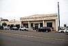 |
(#95000995) |
401 N. Main St. 39°26′45″N 123°48′19″W / 39.445833°N 123.805278°W |
Fort Bragg | |
| 26 | Palace Hotel | 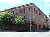 |
(#79003458) |
272 N. State St. 39°09′04″N 123°12′26″W / 39.151111°N 123.207222°W |
Ukiah | |
| 27 | Annie Palmer House | 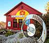 |
(#90001357) |
284 Main St. 38°54′39″N 123°41′30″W / 38.910833°N 123.691667°W |
Point Arena | A small Greek Revival house in Point Arena, named for its notorious one-time owner Annie Palmer. Palmer was a teacher at a local Methodist school until she was convicted of murdering her lover.[18] |
| 28 | Point Arena High School | 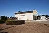 |
(#90001365) |
200 Lake St. 38°54′53″N 123°41′54″W / 38.914722°N 123.698333°W |
Point Arena | |
| 29 | Point Arena Light Station |  |
(#90002189) |
Lighthouse Rd. 38°57′18″N 123°44′24″W / 38.955°N 123.74°W |
Point Arena | |
| 30 | Point Arena Rancheria Roundhouse | Upload image | (#90001360) |
On the Garcia River at the end of Rancheria Rd. 38°57′02″N 123°39′41″W / 38.950556°N 123.661389°W |
Point Arena | |
| 31 | Point Cabrillo Light Station | 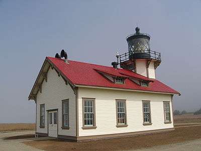 |
(#91001092) |
45300 Lighthouse Rd. 39°20′53″N 123°49′23″W / 39.348056°N 123.823056°W |
Caspar | |
| 32 | Point Cabrillo Site | Upload image | (#72000238) |
Address Restricted |
Pine Grove | |
| 33 | Round Valley Flour Mills |  |
(#80000820) |
Main and Greely Sts. 39°47′35″N 123°14′57″W / 39.793056°N 123.249167°W |
Covelo | |
| 34 | St. Paul's Methodist Episcopal Church | 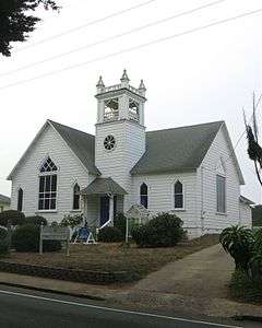 |
(#90001366) |
40 School St. 38°54′50″N 123°41′32″W / 38.913889°N 123.692222°W |
Point Arena | |
| 35 | Seabiscuit's Stud Barn | Upload image | (#13001108) |
16200 N. US 101 39°19′12″N 123°18′29″W / 39.31995°N 123.308178°W |
Willits | |
| 36 | Spotswood House |  |
(#07000997) |
11820 West Rd. 39°19′46″N 123°07′52″W / 39.329451°N 123.131161°W |
Potter Valley | |
| 37 | Sun House | 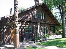 |
(#81000161) |
431 S. Main St. 39°08′51″N 123°12′16″W / 39.1475°N 123.204444°W |
Ukiah | |
| 38 | Town Creek Archeological Site | Upload image | (#76000498) |
Address Restricted |
Covelo | |
| 39 | Ukiah Main Post Office | 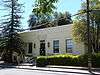 |
(#12000266) |
224 N. Oak St. 39°09′02″N 123°12′36″W / 39.150514°N 123.210086°W |
Ukiah | |
| 40 | Weller House | 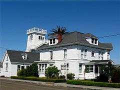 |
(#76000499) |
524 Stewart St. 39°26′50″N 123°48′25″W / 39.447222°N 123.806944°W |
Fort Bragg | Built in Fort Bragg for Horace Weller in 1886, the Weller House is the oldest existing house in the city. Expanded a year later, it came to include three stories with 10 rooms, including a 900 square feet (84 m2) ballroom. It is now a bed & breakfast.[19] |
| 41 | Willits Carnegie Library |  |
(#92001756) |
85 E. Commercial St. 39°24′43″N 123°21′09″W / 39.411944°N 123.3525°W |
Willits | A Classical Revival building built in 1915 by Dan Deshiell.[20] |
| 42 | Willits Depot |  |
(#99001262) |
East Commercial St. 39°24′45″N 123°20′59″W / 39.4125°N 123.349722°W |
Willits |
See also
| Wikimedia Commons has media related to National Register of Historic Places in Mendocino County, California. |
- List of National Historic Landmarks in California
- National Register of Historic Places listings in California
- California Historical Landmarks in Mendocino County, California
References
- ↑ The latitude and longitude information provided in this table was derived originally from the National Register Information System, which has been found to be fairly accurate for about 99% of listings. For about 1% of NRIS original coordinates, experience has shown that one or both coordinates are typos or otherwise extremely far off; some corrections may have been made. A more subtle problem causes many locations to be off by up to 150 yards, depending on location in the country: most NRIS coordinates were derived from tracing out latitude and longitudes off of USGS topographical quadrant maps created under the North American Datum of 1927, which differs from the current, highly accurate WGS84 GPS system used by most on-line maps. Chicago is about right, but NRIS longitudes in Washington are higher by about 4.5 seconds, and are lower by about 2.0 seconds in Maine. Latitudes differ by about 1.0 second in Florida. Some locations in this table may have been corrected to current GPS standards.
- ↑ "National Register of Historic Places: Weekly List Actions". National Park Service, United States Department of the Interior. Retrieved on December 16, 2016.
- ↑ Numbers represent an ordering by significant words. Various colorings, defined here, differentiate National Historic Landmarks and historic districts from other NRHP buildings, structures, sites or objects.
- ↑ National Park Service (2010-07-09). "National Register Information System". National Register of Historic Places. National Park Service.
- ↑ The eight-digit number below each date is the number assigned to each location in the National Register Information System database, which can be viewed by clicking the number.
- ↑ Alvis Hendley. "National Register #79000498: Con Creek School in Mendocino County, California". Noehill.com. Retrieved 2012-09-12.
- ↑ Alvis Hendley. "National Register #80000819: O. W. Getchell House in Mendocino County, California". Noehill.com. Retrieved 2012-09-12.
- ↑ Alvis Hendley. "National Register #90001355: E. P. and Clara Gillmore House in Point Arena, California". Noehill.com. Retrieved 2012-09-12.
- ↑ Alvis Hendley. "National Register #90001356: Sid Groshon House in Point Arena, California". Noehill.com. Retrieved 2012-09-12.
- ↑ "About the Mendocino County Historical Society". Pacificsites.com. Retrieved 2012-09-12.
- ↑ "Held-Poage Memorial Home and Research Library open to public". Ukiah Daily Journal. 2010-07-14. Retrieved 2012-09-12.
- ↑ Alvis Hendley (2010-09-12). "National Register #93001022: Charles Hofman House in Ukiah, California". Noehill.com. Retrieved 2012-09-12.
- ↑ Alvis Hendley. "National Register #90001361: Italian Hotel in Point Arena, California". Noehill.com. Retrieved 2012-09-12.
- ↑ Alvis Hendley. "National Register #90001353: Iverson House in Point Arena, California". Noehill.com. Retrieved 2012-09-12.
- ↑ Alvis Hendley. "National Register #90001358: Billy Ketchum House in Point Arena, California". Noehill.com. Retrieved 2012-09-12.
- ↑ Alvis Hendley. "National Register #90001364: Point Arena Main Street Historic Commercial District". Noehill.com. Retrieved 2012-09-12.
- ↑ Alvis Hendley. "National Register #90001362: LeGrand Morse House in Point Arena, California". Noehill.com. Retrieved 2012-09-12.
- ↑ Alvis Hendley. "National Register #90001357: Annie Palmer House in Point Arena, California". Noehill.com. Retrieved 2012-09-12.
- ↑ Alvis Hendley. "National Register #76000499: Weller House in Fort Bragg, California". Noehill.com. Retrieved 2012-09-12.
- ↑ Alvis Hendley (1989-04-22). "National Register #92001756: Carnegie Free Library in Willits, California". Noehill.com. Retrieved 2012-09-12.
| Topics | |
|---|---|
| Lists by states |
|
| Lists by insular areas | |
| Lists by associated states | |
| Other areas | |
| |
This article is issued from Wikipedia - version of the 1/14/2016. The text is available under the Creative Commons Attribution/Share Alike but additional terms may apply for the media files.