Linden, Indiana
| Linden, Indiana | |
|---|---|
| Town | |
 | |
 Linden, Indiana Linden's location in Montgomery County | |
| Coordinates: 40°11′19″N 86°54′12″W / 40.18861°N 86.90333°WCoordinates: 40°11′19″N 86°54′12″W / 40.18861°N 86.90333°W | |
| Country | United States |
| State | Indiana |
| County | Montgomery |
| Township | Madison |
| Area[1] | |
| • Total | 0.42 sq mi (1.09 km2) |
| • Land | 0.42 sq mi (1.09 km2) |
| • Water | 0 sq mi (0 km2) |
| Elevation | 801 ft (244 m) |
| Population (2010)[2] | |
| • Total | 759 |
| • Estimate (2012[3]) | 758 |
| • Density | 1,807.1/sq mi (697.7/km2) |
| Time zone | Eastern (EST) (UTC-5) |
| • Summer (DST) | EDT (UTC-4) |
| ZIP code | 47955 |
| Area code(s) | 765 |
| FIPS code | 18-44082[4] |
| GNIS feature ID | 0437951[5] |
| Website | http://www.linden.in.gov/ |
Linden is a town in Madison Township, Montgomery County, Indiana, United States. The population was 759 at the 2010 census.
History
Linden was platted in 1852 when the railroad was extended to that point.[6] A post office has been in operation at Linden since 1851.[7]
Linden Depot was listed on the National Register of Historic Places in 1990.[8]
Geography
Linden is located at 40°11′19″N 86°54′12″W / 40.188695°N 86.903311°W.[9]
According to the 2010 census, Linden has a total area of 0.42 square miles (1.09 km2), all land.[1]
Demographics
| Historical population | |||
|---|---|---|---|
| Census | Pop. | %± | |
| 1880 | 130 | — | |
| 1900 | 572 | — | |
| 1910 | 556 | −2.8% | |
| 1920 | 555 | −0.2% | |
| 1930 | 541 | −2.5% | |
| 1940 | 580 | 7.2% | |
| 1950 | 590 | 1.7% | |
| 1960 | 619 | 4.9% | |
| 1970 | 713 | 15.2% | |
| 1980 | 700 | −1.8% | |
| 1990 | 718 | 2.6% | |
| 2000 | 700 | −2.5% | |
| 2010 | 759 | 8.4% | |
| Est. 2015 | 756 | [10] | −0.4% |
2010 census
As of the census[2] of 2010, there were 759 people, 301 households, and 202 families residing in the town. The population density was 1,807.1 inhabitants per square mile (697.7/km2). There were 329 housing units at an average density of 783.3 per square mile (302.4/km2). The racial makeup of the town was 97.1% White, 0.5% African American, 0.9% Native American, 0.1% from other races, and 1.3% from two or more races. Hispanic or Latino of any race were 1.7% of the population.
There were 301 households of which 34.6% had children under the age of 18 living with them, 48.2% were married couples living together, 12.3% had a female householder with no husband present, 6.6% had a male householder with no wife present, and 32.9% were non-families. 28.6% of all households were made up of individuals and 9% had someone living alone who was 65 years of age or older. The average household size was 2.52 and the average family size was 3.03.
The median age in the town was 34 years. 29.2% of residents were under the age of 18; 8.4% were between the ages of 18 and 24; 23.9% were from 25 to 44; 25.9% were from 45 to 64; and 12.6% were 65 years of age or older. The gender makeup of the town was 51.0% male and 49.0% female.
2000 census
As of the census[4] of 2000, there were 700 people, 302 households, and 202 families residing in the town. The population density was 2,703.8 people per square mile (1,039.5/km²). There were 321 housing units at an average density of 1,239.9 per square mile (476.7/km²). The racial makeup of the town was 98.14% White, 0.29% African American, 0.57% Native American, and 1.00% from two or more races. Hispanic or Latino of any race were 0.43% of the population.
There were 302 households out of which 34.1% had children under the age of 18 living with them, 54.0% were married couples living together, 7.9% had a female householder with no husband present, and 33.1% were non-families. 27.8% of all households were made up of individuals and 11.9% had someone living alone who was 65 years of age or older. The average household size was 2.32 and the average family size was 2.80.
In the town the population was spread out with 25.6% under the age of 18, 6.6% from 18 to 24, 31.0% from 25 to 44, 23.0% from 45 to 64, and 13.9% who were 65 years of age or older. The median age was 38 years. For every 100 females there were 97.7 males. For every 100 females age 18 and over, there were 91.5 males.
The median income for a household in the town was $36,750, and the median income for a family was $41,696. Males had a median income of $32,955 versus $22,679 for females. The per capita income for the town was $16,733. About 3.9% of families and 5.0% of the population were below the poverty line, including 6.0% of those under age 18 and 8.4% of those age 65 or over.
Education
North Montgomery School Corporation serves Linden.[12] Secondary school students attend Northridge Middle School and North Montgomery High School. North Montgomery High School lies south of Linden and is attended by students from several surrounding communities.
Features
The town is also home to the Linden Depot Museum, built in 1907 and featuring the oldest intact railroad junction depot in Indiana, and the Linden Carnegie Public Library.
Notable person
Larry Rice, Indy car driver
Gallery
 Welcome sign
 Linden Public Library
 Linden US Post Office
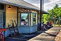 The Linden Depot
 Monon Caboose
External links
References
- 1 2 "G001 - Geographic Identifiers - 2010 Census Summary File 1". United States Census Bureau. Retrieved 2015-07-17.
- 1 2 "American FactFinder". United States Census Bureau. Retrieved 2012-12-11.
- ↑ "Population Estimates". United States Census Bureau. Retrieved 2013-06-25.
- 1 2 "American FactFinder". United States Census Bureau. Retrieved 2008-01-31.
- ↑ "US Board on Geographic Names". United States Geological Survey. 2007-10-25. Retrieved 2008-01-31.
- ↑ Beckwith, Hiram Williams; Kennedy, P. S. (1881). History of Montgomery County, Together with Historic Notes on the Wabash Valley. H. H. Hill and N. Iddings. p. 433.
- ↑ "Montgomery County". Jim Forte Postal History. Retrieved 7 September 2015.
- ↑ National Park Service (2010-07-09). "National Register Information System". National Register of Historic Places. National Park Service.
- ↑ "US Gazetteer files: 2010, 2000, and 1990". United States Census Bureau. 2011-02-12. Retrieved 2011-04-23.
- ↑ "Annual Estimates of the Resident Population for Incorporated Places: April 1, 2010 to July 1, 2015". Retrieved July 2, 2016.
- ↑ "Census of Population and Housing". Census.gov. Retrieved June 4, 2015.
- ↑ "SCHOOL DISTRICT REFERENCE MAP (2010 CENSUS): Montgomery County, IN." U.S. Census Bureau. Retrieved on November 26, 2016.
Municipalities and communities of Montgomery County, Indiana, United States | ||
|---|---|---|
| City | ||
| Towns | ||
| Townships | ||
| CDP | ||
| Other unincorporated communities |
| |