Lincoln County, West Virginia
| Lincoln County, West Virginia | |
|---|---|
| County | |
| Lincoln County | |
 The Lincoln County Courthouse in Hamlin in 2007 | |
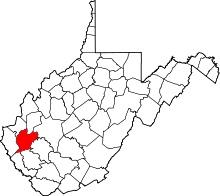 Location in the U.S. state of West Virginia | |
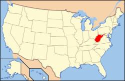 West Virginia's location in the U.S. | |
| Founded | February 23, 1867 |
| Named for | Abraham Lincoln |
| Seat | Hamlin |
| Largest town | Hamlin |
| Area | |
| • Total | 439 sq mi (1,137 km2) |
| • Land | 437 sq mi (1,132 km2) |
| • Water | 1.6 sq mi (4 km2), 0.4% |
| Population (est.) | |
| • (2015) | 21,415 |
| • Density | 49/sq mi (19/km²) |
| Congressional district | 3rd |
| Time zone | Eastern: UTC-5/-4 |
| Website |
www |
Lincoln County is a county located in the U.S. state of West Virginia. As of the 2010 census, the population was 21,720.[1] Its county seat is Hamlin.[2] The county was created in 1867 and named for Abraham Lincoln.[3]
Lincoln County is part of the Huntington-Ashland, WV-KY-OH, Metropolitan Statistical Area, which is also included in the Charleston-Huntington-Ashland, WV-OH-KY Combined Statistical Area.
The county is probably best known as the birthplace of Chuck Yeager.
History
Lincoln County was created by an act of the West Virginia Legislature on February 23, 1867, from parts of Boone, Cabell, Kanawha and Putnam counties. By 1869, the county had returned much of its Putnam County territory and absorbed the northern portion of Logan County and a portion of Wayne County. In 1869, Harts Creek Township (later district) was created from this latter region. Lincoln County is one of five counties created by West Virginia since the Civil War. Hamlin, seat of government for the county, was established in 1853.
Jesse, John, David, William, and Moses McComas were the first Anglo settlers in what is now Lincoln County. They cultivated 20 acres (81,000 m2) of corn, the first ever grown in the area near present-day West Hamlin, in 1799. Later that year, they returned to eastern Virginia to get their families. Their families were initially left behind because it was not known if there were any hostile Native Americans in the area, or if the soil would be suitable for cultivation. John Lucas, William Hinch, and John Johnson soon joined the McComases in the county. They built cabins in the county around 1800. About 1804, William Wirt Brumfield settled at the mouth of Big Ugly Creek.
During the Civil War, based on military enlistments, Lincoln County appears to have been evenly divided in its sympathies. The county hosted a handful of small skirmishes, mostly centered on Mud River.
After the Civil War, timbering constituted the county's primary industry. The county also became nationally known for its tobacco cultivation. In the early twentieth century, the county experienced a gas boom.
Geography
According to the U.S. Census Bureau, the county has a total area of 439 square miles (1,140 km2), of which 437 square miles (1,130 km2) is land and 1.6 square miles (4.1 km2) (0.4%) is water.[4]
Major highways
 U.S. Highway 119
 West Virginia Route 3
 West Virginia Route 10
 West Virginia Route 34
 West Virginia Route 37
 West Virginia Route 214
Adjacent counties
- Putnam County (north)
- Kanawha County (northeast)
- Boone County (southeast)
- Logan County (south)
- Mingo County (southwest)
- Wayne County (west)
- Cabell County (northwest)
Demographics
| Historical population | |||
|---|---|---|---|
| Census | Pop. | %± | |
| 1870 | 5,053 | — | |
| 1880 | 8,739 | 72.9% | |
| 1890 | 11,246 | 28.7% | |
| 1900 | 15,434 | 37.2% | |
| 1910 | 20,491 | 32.8% | |
| 1920 | 19,378 | −5.4% | |
| 1930 | 19,156 | −1.1% | |
| 1940 | 22,886 | 19.5% | |
| 1950 | 22,466 | −1.8% | |
| 1960 | 20,267 | −9.8% | |
| 1970 | 18,912 | −6.7% | |
| 1980 | 23,675 | 25.2% | |
| 1990 | 21,382 | −9.7% | |
| 2000 | 22,108 | 3.4% | |
| 2010 | 21,720 | −1.8% | |
| Est. 2015 | 21,415 | [5] | −1.4% |
| U.S. Decennial Census[6] 1790–1960[7] 1900–1990[8] 1990–2000[9] 2010–2015[1] | |||
2000 census
As of the census[10] of 2000, there were 22,108 people, 8,664 households, and 6,532 families residing in the county. The population density was 50 people per square mile (20/km²). There were 9,846 housing units at an average density of 22 per square mile (9/km²). The racial makeup of the county was 99.04% White, 0.06% Black or African American, 0.17% Native American, 0.06% Asian, 0.01% Pacific Islander, 0.06% from other races, and 0.61% from two or more races. 0.55% of the population were Hispanic or Latino of any race.
There were 8,664 households out of which 33.00% had children under the age of 18 living with them, 60.40% were married couples living together, 10.80% had a female householder with no husband present, and 24.60% were non-families. 22.20% of all households were made up of individuals and 10.40% had someone living alone who was 65 years of age or older. The average household size was 2.54 and the average family size was 2.94.
In the county, the population was spread out with 23.60% under the age of 18, 9.30% from 18 to 24, 29.10% from 25 to 44, 24.90% from 45 to 64, and 13.10% who were 65 years of age or older. The median age was 37 years. For every 100 females there were 97.20 males. For every 100 females age 18 and over, there were 96.00 males.
The median income for a household in the county was $22,662, and the median income for a family was $28,297. Males had a median income of $30,810 versus $18,270 for females. The per capita income for the county was $13,073. About 22.80% of families and 27.90% of the population were below the poverty line, including 37.60% of those under age 18 and 20.80% of those age 65 or over.
2010 census
As of the 2010 United States Census, there were 21,720 people, 8,783 households, and 6,268 families residing in the county.[11] The population density was 49.7 inhabitants per square mile (19.2/km2). There were 9,887 housing units at an average density of 22.6 per square mile (8.7/km2).[12] The racial makeup of the county was 99.0% white, 0.1% Asian, 0.1% American Indian, 0.1% black or African American, 0.1% from other races, and 0.6% from two or more races. Those of Hispanic or Latino origin made up 0.4% of the population.[11] In terms of ancestry, 27.0% were American, 12.8% were Irish, 12.4% were English, and 12.4% were German.[13]
Of the 8,783 households, 32.3% had children under the age of 18 living with them, 55.3% were married couples living together, 10.7% had a female householder with no husband present, 28.6% were non-families, and 25.6% of all households were made up of individuals. The average household size was 2.47 and the average family size was 2.92. The median age was 41.2 years.[11]
The median income for a household in the county was $30,868 and the median income for a family was $37,667. Males had a median income of $43,662 versus $23,166 for females. The per capita income for the county was $16,439. About 22.8% of families and 26.6% of the population were below the poverty line, including 37.7% of those under age 18 and 13.2% of those age 65 or over.[14]
Politics
| Year | Republican | Democrat |
|---|---|---|
| 2016 | 74.47% 5,257 | 20.33% 1,435 |
| 2012 | 64.29% 4,383 | 32.66% 2,227 |
| 2008 | 53.21% 3,637 | 44.32% 3,029 |
| 2004 | 49.35% 4,102 | 48.70% 4,048 |
| 2000 | 45.40% 3,389 | 52.77% 3,939 |
Communities
Towns
- Hamlin (county seat)
- West Hamlin
Census-designated places
- Alum Creek (part)
- Harts
Unincorporated communities
- Atenville
- Branchland
- Eden Park
- Ferrellsburg
- Fourteen
- Gill
- Green Shoal
- Griffithsville
- Leet
- Midkiff
- Myra
- Pleasant View
- Ranger
- Rector
- Sweetland
- Toney
- Warren
- Wewanta
- Yawkey
Notable residents
- Dagmar, actress
- Lloyd G. Jackson, politician
- Clark Kessinger, fiddler
- Clark W. May, politician
- J. S. Pridemore, captain of industry
- Russ Thomas, professional football player
- John S. Witcher, Civil War general
- Chuck Yeager, aviator
See also
- Big Ugly Wildlife Management Area
- National Register of Historic Places listings in Lincoln County, West Virginia
References
- 1 2 "State & County QuickFacts". United States Census Bureau. Retrieved July 24, 2015.
- ↑ "Find a County". National Association of Counties. Retrieved 2011-06-07.
- ↑ Gannett, Henry (1905). The Origin of Certain Place Names in the United States. U.S. Government Printing Office. p. 187.
- ↑ "2010 Census Gazetteer Files". United States Census Bureau. August 22, 2012. Retrieved July 24, 2015.
- ↑ "County Totals Dataset: Population, Population Change and Estimated Components of Population Change: April 1, 2010 to July 1, 2015". Retrieved July 2, 2016.
- ↑ "U.S. Decennial Census". United States Census Bureau. Retrieved January 10, 2014.
- ↑ "Historical Census Browser". University of Virginia Library. Retrieved January 10, 2014.
- ↑ "Population of Counties by Decennial Census: 1900 to 1990". United States Census Bureau. Retrieved January 10, 2014.
- ↑ "Census 2000 PHC-T-4. Ranking Tables for Counties: 1990 and 2000" (PDF). United States Census Bureau. Retrieved January 10, 2014.
- ↑ "American FactFinder". United States Census Bureau. Retrieved 2011-05-14.
- 1 2 3 "DP-1 Profile of General Population and Housing Characteristics: 2010 Demographic Profile Data". United States Census Bureau. Retrieved 2016-04-03.
- ↑ "Population, Housing Units, Area, and Density: 2010 - County". United States Census Bureau. Retrieved 2016-04-03.
- ↑ "DP02 SELECTED SOCIAL CHARACTERISTICS IN THE UNITED STATES – 2006-2010 American Community Survey 5-Year Estimates". United States Census Bureau. Retrieved 2016-04-03.
- ↑ "DP03 SELECTED ECONOMIC CHARACTERISTICS – 2006-2010 American Community Survey 5-Year Estimates". United States Census Bureau. Retrieved 2016-04-03.
- ↑ "Dave Leip's Atlas of U.S. Presidential Elections". Retrieved 2016-11-18.
External links
 |
Cabell County | Putnam County | Kanawha County | |
| Wayne County | |
|||
| ||||
| | ||||
| Mingo County | Logan County | Boone County |
Coordinates: 38°11′N 82°04′W / 38.18°N 82.07°W
Municipalities and communities of Lincoln County, West Virginia, United States | ||
|---|---|---|
| Towns | | |
| CDPs | ||
| Unincorporated communities |
| |
| Footnotes | ‡This populated place also has portions in an adjacent county or counties | |
| Principal cities |  | |
|---|---|---|
| Municipalities with population over 5,000 | ||
| Municipalities with population 1,000–5,000 | ||
| Municipalities with population under 1,000 | ||
| West Virginia counties | ||
| Kentucky counties | ||
| Ohio counties | ||