Limmat
| Limmat | |
|---|---|
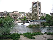
 The Limmat in Zürich, looking downstream to Rathausbrücke from Quaibrücke at Lake Zurich, Stadthausquai to the left and Limmatquai to right. | |
 | |
| Country | Switzerland |
| Cantons | Zurich, Aargau |
| Settlements | Zürich (ZH), Schlieren (ZH), Dietikon (ZH), Oetwil a.d.L. (ZH), Wettingen (AG), Baden (AG), Ennetbaden (AG), Nussbaumen (AG), Turgi (AG), Untersiggenthal (AG) |
| Basin | |
| Main source |
Lake Zurich, Zurich 406 m (1,332 ft) 47°22′00″N 8°32′35″E / 47.36677°N 8.54316°E |
| River mouth |
Aare, Gebenstorf 328 m (1,076 ft) 47°30′07″N 8°14′15″E / 47.5019°N 8.2375°ECoordinates: 47°30′07″N 8°14′15″E / 47.5019°N 8.2375°E |
| Alt. difference | 78 m (256 ft) |
| Progression | Aare–Rhine–North Sea |
| Basin size | 2,416 km2 (933 sq mi) (Lake Zurich and Linth included) |
| Physical characteristics | |
| Length | 36.3 kilometres (22.6 mi), 140 kilometres (87 mi) (Lake Zurich and Linth included) |
| Discharge |
|
| Features | |
| Tributaries | |
| Waterbodies | Lake Zurich, Stausee Wettingen |


The Limmat is a river in Switzerland. The river commences at the outfall of Lake Zurich, in the southern part of the city of Zurich. From Zurich it flows in a northwesterly direction, after 35 km reaching the river Aare. The confluence is located north of the small town of Brugg and shortly after the mouth of the Reuss.
The main towns along the Limmat Valley downstream of Zurich are Dietikon, Wettingen, and Baden. Its main tributaries are the Linth, via Lake Zurich, the Sihl, in Zurich, and the Reppisch, in Dietikon.
The hydronym is first attested in the 8th century, as Lindimacus. It is of Gaulish origin, from *lindo- "lake" and *magos "plain", and was thus presumably in origin the name of the plain formed by the Linth.[1]
Power generation
Like many Swiss rivers, the Limmat is intensively used for production of hydroelectric power: along its course of 35 km (22 mi), its fall is used by no less than ten hydroelectric power stations. These include:
| Station | Capacity (MW) | Location | Geographic coordinates |
|---|---|---|---|
| Aue Power Station[2] | 3.9 | Baden | 47°28′13″N 8°18′40″E / 47.47034°N 8.31098°E |
| Dietikon Power Station[3] | 2.6 | Dietikon | 47°24′36″N 8°24′30″E / 47.410137°N 8.408344°E |
| Höngg Power Station[4] | 1 | Zurich | 47°24′07″N 8°29′13″E / 47.401835°N 8.487035°E |
| Kappelerhof Power Station[2] | 6.8 | Baden | 47°29′04″N 8°17′35″E / 47.484469°N 8.292945°E |
| Letten Power Station[5] | 4 | Zurich | 47°23′15″N 8°31′56″E / 47.387396°N 8.532321°E |
| Schiffmühle Power Station[2] | 2.6 | Untersiggenthal | 47°29′19″N 8°15′54″E / 47.488687°N 8.264937°E |
| Turgi Power Station[2] | 1 | Turgi | |
| Wettingen Power Station[6] | 26 | Wettingen | 47°27′24″N 8°19′14″E / 47.456554°N 8.320631°E |
Navigation
Historically, the Limmat was an important navigation route. In the twelfth and thirteenth centuries, voyages from Zurich to Koblenz are recorded. In 1447, the Emperor Frederick III granted the privilege of free navigation on the Limmat and on the Rhine to Zurich. Because of the current, navigation was typically downstream only, with the barges being sold on arrival.[7]
Today, the Limmat is navigable for much of its length by small craft only, with many of the hydroelectric power plants incorporating boat lifts. The traditional boat type used on the river is the weidling, a flat-bottomed vessel that is usually 10 metres (33 ft) long.[8][9]
The uppermost stretch of the river through the centre of Zurich is navigable by rather larger vessels, albeit limited by low bridges. On this stretch of the river the Zürichsee-Schifffahrtsgesellschaft (Lake Zurich Navigation Company) operates its Limmat boat service, from the Landesmuseum to Lake Zurich, using low-profile motor boats.[10]
Towns near the river
- In the canton of Zurich:
- In the canton of Aargau
Cultural Heritage
Located on the then swamp land between Limmat and Zürichsee around Sechseläutzenplatz on small islands and peninsulas in Zürich, Prehistoric pile dwellings around Zürichsee were set on piles to protect against occasional flooding by the Linth and Jona. Zürich–Enge Alpenquai is located on Zürichsee lakeshore in Enge, a locality of the municipality of Zürich. It was neighbored by the settlements at Kleiner Hafner and Grosser Hafner on a then peninsula respectively island in the effluence of the Limmat, within an area of about 0.2 square kilometres (49.42 acres) in the city of Zürich. As well as being part of the 56 Swiss sites of the UNESCO World Heritage Site Prehistoric pile dwellings around the Alps, the settlement is also listed in the Swiss inventory of cultural property of national and regional significance as a Class object.[11][12][13]
References
- ↑ Felix Stähelin (1935), "Die vorrömische Schweiz im Lichte geschichtlicher Zeugnisse und sprachlicher Tatsachen", Zeitschrift für schweizerische Geschichte (in German), Leemann, Band 15, pp. 337–368
- 1 2 3 4 "Limmat Power Generation". Regional Werke AG Baden. Retrieved 2013-04-25.
- ↑ "Flusskraftwerk Dietikon". Elektrizitätswerke des Kantons Zürich. Retrieved 2013-04-25.
- ↑ "Kraftwerk Höngg". City of Zurich. Retrieved 2013-04-25.
- ↑ "Kraftwerk Letten". City of Zurich. Retrieved 2013-04-25.
- ↑ "Kraftwerk Wettingen". City of Zurich. Retrieved 2013-04-25.
- ↑ "Limmat". Historical Dictionary of Switzerland (in German). Retrieved 2013-04-24.
- ↑ "Funicular Boat Lifts of Switzerland". funimag.com. Retrieved 2013-04-24.
- ↑ "Clubportrait Schiffe" (in German). Retrieved 2013-04-24.
- ↑ "Limmat river cruises". Zürichsee-Schifffahrtsgesellschaft. Retrieved 2013-04-24.
- ↑ "A-Objekte KGS-Inventar". Schweizerische Eidgenossenschaft, Amt für Bevölkerungsschutz. 2009. Retrieved 2014-12-10.
- ↑ "Prehistoric Pile Dwellings in Switzerland". Swiss Coordination Group UNESCO Palafittes (palafittes.org). Retrieved 2014-12-10.
- ↑ "World Heritage". palafittes.org. Retrieved 2014-12-10.
External links
-
 Media related to Limmat at Wikimedia Commons
 - Media related to Limmat in Zürich at Wikimedia Commons
- Limmat in German, French and Italian in the online Historical Dictionary of Switzerland.
| Settlements | 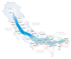 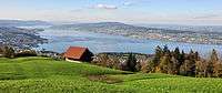 | |
|---|---|---|
| Islands | ||
| Rivers | ||
| Valleys | ||
| Mountains | ||
| Landmarks | ||
| Transportation |
| |
| People | ||