Magdalen Islands
|
The Magdalen Islands | |
| Geography | |
|---|---|
| Location | Atlantic Ocean |
| Coordinates | 47°26′54″N 61°45′08″W / 47.44833°N 61.75222°W |
| Area | 205.53 km2 (79.36 sq mi) |
| Administration | |
|
Canada | |
| Province | Quebec |
| Demographics | |
| Population | 12,781 (2011) |
| Pop. density | 62.2 /km2 (161.1 /sq mi) |

The Magdalen Islands (French: les Îles de la Madeleine [lezɪl dəla madˈlɛn]) form a small archipelago in the Gulf of Saint Lawrence with a land area of 205.53 square kilometres (79.36 sq mi). Though closer to Prince Edward Island and Nova Scotia, the islands form part of the Canadian province of Quebec.
The islands form the territory equivalent to a regional county municipality (TE) and census division (CD) of Les Îles-de-la-Madeleine. Its geographical code is 01.
The islands also form the urban agglomeration of Les Îles-de-la-Madeleine, divided into two municipalities. These are Les Îles-de-la-Madeleine (2011 census pop. 12,291), the central municipality, and Grosse-Île (pop. 490). The mayors are Jonathan Lapierre and Rose Elmonde Clarke, respectively.
Geography
There are eight major islands: Amherst, Grande Entrée, Grindstone, Grosse-Île, House Harbour, Pointe-Aux-Loups, Entry Island and Brion.[1][2] All except Brion are inhabited. There are several other tiny islands that are also considered part of the archipelago: Rocher aux Oiseaux, Île aux Loups-marins, Île Paquet and Rocher du Corps Mort.[3]
The islands' interiors were once completely covered with pine forests.[2] An ancient salt dome underlies the archipelago.[1][4] The inherent buoyancy of the salt forces the uplift of overlying Permian red sandstone.
Nearby salt domes are believed to be sources of fossil fuels.[5] Rock salt is mined on the Islands.[6]
History
In 1534 Jacques Cartier was the first European to visit the islands. However, Mi'kmaqs had been visiting the islands for hundreds of years as part of a seasonal subsistence migration,[7] probably to harvest the abundant walrus population. A number of archaeological sites have been excavated on the archipelago.
The archipelago was named in 1663 by François Doublet (1619 or 1620 - approx. 1678), the seigneur of the island, after his wife, Madeleine Fontaine.[8] In 1765, the islands were inhabited by 22 French-speaking Acadians and their families. They were working and hunting walruses for British trader Richard Gridley. To this day, many inhabitants of the Magdalen Islands (Madelinots) fly the Acadian flag and identify as both Acadian and Québécois.
The islands were administered as part of the British Colony of Newfoundland from 1763 until 1774. That year they were joined to Quebec by the Quebec Act.
A segment of the population are descendants of survivors of the more than 400 shipwrecks on the islands. The islands have some of Quebec's oldest English-speaking settlements. Although the majority of anglophones have long since assimilated with the francophone population or migrated elsewhere, English-speaking settlements are found at Old Harry, Grosse-Ile, and Entry Island. The islands are known for a children's French camp. Activities include sand-castle competitions and a night alone in the woods.
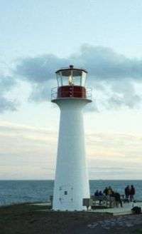
To improve ship safety, the government constructed lighthouses on the islands. They indicate navigable channels and have reduced the number of shipwrecks. But many old hulks are found on the beaches and under the waters.
Until the 20th century, the islands were completely isolated during the winter, since the pack ice made the trip to the mainland impassable by boat. The inhabitants of the islands had no means of communication with the mainland. An underwater cable was installed to enable communication by telegraph. In the winter of 1910, the cable broke and the islands were again isolated. Residents sent an urgent request for help to the mainland by writing letters and sealing them inside a molasses barrel (or puncheon), which they set adrift. It reached the shore on Cape Breton Island, where residents notified the government of the Madelinots' emergency. The government sent an icebreaker to bring aid. Within a few years, the government constructed new wireless telegraph stations on the Magdalens to ensure they had communication in the winter. The puncheon became famous as a symbol of survival; every tourist shop sells replicas.
At one time, large walrus herds were found near the islands but they had been destroyed by the end of the 18th century due to overhunting. In the 21st century, the islands' beaches provide habitat for the endangered piping plover and the roseate tern.
On March 29, 2016, a small private plane crashed short of the airport at Havre-aux-Maisons. All seven passengers died, including former federal cabinet minister Jean Lapierre and four members of his family: his wife Nicole Beaulieu; his sister Martine Lapierre; and brothers Marc and Louis Lapierre; and both pilots Pascal Gosselin and Fabrice Labourel. The Lapierre family members were traveling to the island for the funeral of their father Raymond Lapierre.[9] All deceased Lapierre family members were honoured in a service held on April 8 on the island. They are survived by Lucie Lapierre, Raymond's widow; and Marie-Anne and jean-Michel Lapierre, children of Jean Lapierre by his first marriage.[10] Lapierre and Beaulieu were given a funeral at Saint-Viateur d'Outremont church on April 16, 2016, attended by extended family, friends and political and broadcasting colleagues.[11]
Demographics
Population
| Canada census – Les Îles-de-la-Madeleine, Quebec community profile | |||
|---|---|---|---|
| 2011 | 2006 | 2001 | |
| Population: | 12,781 (-2.4% from 2006) | 13,091 (+2.1% from 2001) | 12,824 (-7.1% from 1996) |
| Land area: | 205.40 km2 (79.31 sq mi) | 205.40 km2 (79.31 sq mi) | 205.53 km2 (79.36 sq mi) |
| Population density: | 62.2/km2 (161/sq mi) | 63.7/km2 (165/sq mi) | 62.4/km2 (162/sq mi) |
| Median age: | 48.1 (M: 47.9, F: 48.4) | 44.5 (M: 44.1, F: 44.9) | 41.1 (M: 41.0, F: 41.2) |
| Total private dwellings: | 6,153 | 5,838 | 5,289 |
| Median household income: | $52,267 | $47,914 | $40,996 |
| References: 2011[12] 2006[13] 2001[14] | |||
| Historical Census Data - Les Îles-de-la-Madeleine, Quebec[15] | ||||||||||||||||||||||||||
|---|---|---|---|---|---|---|---|---|---|---|---|---|---|---|---|---|---|---|---|---|---|---|---|---|---|---|
|
|
| ||||||||||||||||||||||||
Language
| Canada Census Mother Tongue - Les Îles-de-la-Madeleine, Quebec[15] | ||||||||||||||||||
|---|---|---|---|---|---|---|---|---|---|---|---|---|---|---|---|---|---|---|
| Census | Total | French |
English |
French & English |
Other | |||||||||||||
| Year | Responses | Count | Trend | Pop % | Count | Trend | Pop % | Count | Trend | Pop % | Count | Trend | Pop % | |||||
| 2011 |
12,660 |
11,900 | |
94.00% | 695 | |
5.49% | 40 | |
0.32% | 25 | |
0.20% | |||||
| 2006 |
12,975 |
12,030 | |
92.72% | 830 | |
6.40% | 50 | |
0.38% | 65 | |
0.50% | |||||
| 2001 |
12,575 |
11,800 | |
93.84% | 710 | |
5.65% | 25 | |
0.20% | 40 | |
0.32% | |||||
| 1996 |
13,730 |
12,925 | n/a | 0.00% | 715 | n/a | 0.00% | 60 | n/a | 0.00% | 30 | n/a | 0.00% | |||||
Climate
The maritime climate enjoyed by Magdalen Islands is markedly different from that of the mainland. The huge water masses that circle the archipelago temper the weather and create milder conditions in each season. On the islands, winter is mild, spring is cool, there are few heat waves in summer, and fall is typically warm. The Magdalen Islands have the least amount of annual frost in the Province of Québec. The warm breezes of summer persist well into September, and sometimes early October.[16] However, in spite of this under the Köppen climate classification its climate is humid continental, due to its winters averaging far below freezing by maritime standards.
The highest temperature ever recorded in Îles-de-la-Madeleine was 31.1 °C (88 °F) on 31 July 1949.[17] The coldest temperature ever recorded was −27.2 °C (−17 °F) on 14 February 1891.[17]
| Climate data for Îles-de-la-Madeleine Airport, 1981–2010 normals, extremes 1890–present[lower-alpha 1] | |||||||||||||
|---|---|---|---|---|---|---|---|---|---|---|---|---|---|
| Month | Jan | Feb | Mar | Apr | May | Jun | Jul | Aug | Sep | Oct | Nov | Dec | Year |
| Record high °C (°F) | 12.3 (54.1) |
9.0 (48.2) |
12.0 (53.6) |
17.2 (63) |
25.0 (77) |
28.9 (84) |
31.1 (88) |
30.6 (87.1) |
28.3 (82.9) |
21.6 (70.9) |
16.7 (62.1) |
12.6 (54.7) |
31.1 (88) |
| Average high °C (°F) | −3.1 (26.4) |
−4.3 (24.3) |
−1.0 (30.2) |
3.8 (38.8) |
10.5 (50.9) |
16.1 (61) |
20.4 (68.7) |
21.0 (69.8) |
16.8 (62.2) |
10.9 (51.6) |
5.2 (41.4) |
0.2 (32.4) |
8.0 (46.4) |
| Daily mean °C (°F) | −6.4 (20.5) |
−8.2 (17.2) |
−4.1 (24.6) |
1.2 (34.2) |
7.0 (44.6) |
12.5 (54.5) |
17.1 (62.8) |
17.8 (64) |
13.9 (57) |
8.2 (46.8) |
2.8 (37) |
−2.3 (27.9) |
5.0 (41) |
| Average low °C (°F) | −9.7 (14.5) |
−12 (10) |
−7.1 (19.2) |
−1.5 (29.3) |
3.5 (38.3) |
8.9 (48) |
13.8 (56.8) |
14.6 (58.3) |
10.9 (51.6) |
5.6 (42.1) |
0.4 (32.7) |
−4.8 (23.4) |
1.9 (35.4) |
| Record low °C (°F) | −26.5 (−15.7) |
−27.2 (−17) |
−26.1 (−15) |
−12.9 (8.8) |
−6.1 (21) |
0.0 (32) |
1.8 (35.2) |
3.9 (39) |
−1.1 (30) |
−5.6 (21.9) |
−12.8 (9) |
−24.4 (−11.9) |
−27.2 (−17) |
| Average precipitation mm (inches) | 97.3 (3.831) |
74.3 (2.925) |
76.0 (2.992) |
73.7 (2.902) |
86.3 (3.398) |
76.3 (3.004) |
75.5 (2.972) |
84.7 (3.335) |
95.8 (3.772) |
94.1 (3.705) |
108.9 (4.287) |
94.3 (3.713) |
1,037.3 (40.839) |
| Average rainfall mm (inches) | 37.1 (1.461) |
27.4 (1.079) |
39.0 (1.535) |
56.7 (2.232) |
82.0 (3.228) |
76.3 (3.004) |
75.5 (2.972) |
84.2 (3.315) |
95.8 (3.772) |
93.3 (3.673) |
91.6 (3.606) |
43.6 (1.717) |
802.6 (31.598) |
| Average snowfall cm (inches) | 61.1 (24.06) |
47.5 (18.7) |
37.0 (14.57) |
17.0 (6.69) |
4.5 (1.77) |
0.0 (0) |
0.0 (0) |
0.0 (0) |
0.0 (0) |
0.7 (0.28) |
17.3 (6.81) |
51.7 (20.35) |
236.8 (93.23) |
| Average precipitation days (≥ 0.2 mm) | 22.2 | 16.6 | 16.8 | 14.0 | 14.5 | 12.4 | 13.1 | 12.5 | 13.1 | 17.4 | 19.1 | 21.4 | 193.1 |
| Average rainy days (≥ 0.2 mm) | 5.6 | 4.3 | 7.3 | 10.6 | 14.1 | 12.3 | 13.1 | 12.5 | 13.1 | 17.2 | 14.1 | 7.2 | 131.2 |
| Average snowy days (≥ 0.2 cm) | 20.2 | 14.4 | 12.3 | 6.1 | 0.95 | 0.0 | 0.0 | 0.0 | 0.0 | 0.61 | 7.8 | 17.9 | 80.2 |
| Source: Environment Canada[18][17][19] | |||||||||||||
Tourism
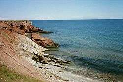
Tourism is a major industry on the Magdalen Islands. The islands have many kilometres of white sand beaches, along with steadily eroding sandstone cliffs. They are a destination for bicycle camping, sea kayaking, windsurfing and kitesurfing. During the winter months, beginning in mid-February, eco-tourists visit to observe new-born and young harp seal pups on the pack ice in the Gulf of St. Lawrence surrounding the islands.
Industry
The island is home to Canadian Salt Company Seleine Mines, which produces road salt for use in Quebec, Atlantic Canada and the United States' eastern seaboard.[20] Opened in 1982, the salt mine and plant is located in Grosse-Île and extracts salt from an underground mine 30 metres (98 ft) below Grande-Entrée Lagoon. It produces 1 million tons of salt, and employs 200 people.
Transportation
The Coopérative de transport maritime et aérien (Groupe C.T.M.A.) operates a ferry service between terminals in Souris, Prince Edward Island and Cap-aux-Meules. Groupe C.T.M.A. also operates a seasonal cruise ferry service between the islands and Montreal.[21]
The Magdalen Islands Airport at Havre-aux-Maisons offers scheduled air service to Labrador and mainland Quebec.
See also
- List of regional county municipalities and equivalent territories in Quebec
- Quebec Route 199, the only provincial highway on the islands
- Coopérative de transport maritime et aérien, the ferry company serving the Magdalen Islands
- Municipal reorganization in Quebec
- List of Quebec regions
- Coins of the Magdalen Islands (numismatic history).
References
- 1 2 K.G. Andrew Hamilton (2002). "Iles-de-la-Madeleine (Magdalen Is.): a glacial refugium for short-horned bugs (Homoptera: Auchenorrhyncha)?" (PDF). Le Naturaliste Canadien. p. 36. Archived (PDF) from the original on 2014-02-19. Retrieved 2014-09-09.
All the archipelago except Le Corps Mort now lie on a single submerged plateau surrounded by shallow, sun-warmed waters which gives the islands a long, mild summer for their latitude. This plateau is a weakly sloped mound resembling a huge alluvial fan 130 by 150 km; but it is in fact covered by a rather thin layer of sediment of modern origin as all sediments older than 20,000 years have been removed from the Magdalen shelf (Loring and Nota, 1973). The plateau's convex shape is formed by a "salt dome" of ancient origin.
- 1 2 "Magdalen Islands". Canadian Parks and Wilderness Society. Archived from the original on 2012-06-16. Retrieved 2014-09-09.
The Magdalen Islands form an archipelago located in the centre of the Gulf of Saint Lawrence. In total, the land, dunes and offshore sand bars of the islands comprise about 200 square kilometres.
- ↑ The Archipelago
- ↑ "Ecotourism at its best". Iles Madeleine. 2008. Archived from the original on 2013-10-13. Retrieved 2014-09-09.
As the salt dome below the ground boiled up, the petrified seabed above "cracked" as it rose up.
- ↑ Antoine Dion-Ortega (2012-11). "Fossil fuel exploration in Quebec: Uncertainty rules". CIM magazine. Archived from the original on 2014-08-03. Retrieved 2014-09-09.
Some 80 kilometres east of the Magdalen Islands, across the border from Newfoundland and Labrador, lies the 30-kilometre-long by 12-kilometre-wide Old Harry structure.
Check date values in:|date=(help) - ↑ Dennis S. Kostick (1995). "Salt" (PDF). USGS Mineral Resources Program. Archived (PDF) from the original on 2014-02-19. Retrieved 2014-09-09.
A mine accident occurred on April 28 at Canadian Salt Co., Ltd.'s Mines Saleine underground rock salt operation in the St. Magdalen Islands, Quebec. Ocean water began entering the mine around the mine shaft, which was situated 250 meters below sea level, and continued to flood until mine engineers tried to stabilize the waterflow, which was calculated to be about 240 liters per minute.
- ↑ Martijn, Charles (2003). "Early Mikmaq Presence in Southern Newfoundland: An Ethnohistorical Perspective, c.1500-1763". Newfoundland and Labrador Studies. 19 (1): 44–102. ISSN 1715-1430. Retrieved 2012-04-29.
- ↑ Toponymie du Québec
- ↑ "Former federal cabinet minister Jean Lapierre among seven people killed in plane crash", The Star (Canada), Accessed 30 March 2016
- ↑ "Une cérémonie toute madelinienne pour la famille Lapierre", Radio Canada (French), 8 April 2016, accessed 19 May 2016
- ↑ Morgan Lowrie, The Canadian Press, " 'Papa, we are so proud to be your children': Jean Lapierre's family says final goodbye", CTV News, 16 April 2016, accessed 19 May 2016
- ↑ "2011 Community Profiles". Canada 2011 Census. Statistics Canada. July 5, 2013. Retrieved 2014-02-23.
- ↑ "2006 Community Profiles". Canada 2006 Census. Statistics Canada. March 30, 2011. Retrieved 2014-02-23.
- ↑ "2001 Community Profiles". Canada 2001 Census. Statistics Canada. February 17, 2012. Retrieved 2014-02-23.
- 1 2 Statistics Canada: 1996, 2001, 2006, 2011 census
- ↑ http://www.tourismeilesdelamadeleine.com/en/discover-the-islands/useful-informations/climate/
- 1 2 3 , accessed 23 June 2016.
- ↑ , accessed 16 March 2012.
- ↑ , accessed 23 June 2016.
- ↑ Windsor Salt
- ↑ Schedule and rates - Ferry - Sea links crossing Îles de la Madeleine and Prince Edouard Island ferry, cruise on St-Lawrence
- ↑ Climate data was recorded on Grindstone Island in the community of Cap-aux-Meules from August 1890 to February 1983 and at Îles-de-la-Madeleine Airport from May 1983 to present.
External links
| Wikivoyage has a travel guide for Îles-de-la-Madeleine. |
| Wikimedia Commons has media related to Magdalen Islands. |
- Municipalité des Îles-de-la-Madeleine
- Municipalités et villes de la Gaspésie
- Magdalen Islands tourist association
- The official tourist site of the islands
- Quebec tourism information on the Magdalen Islands including a map (with the French names)
 |
Gulf of Saint Lawrence | | ||
| Gulf of Saint Lawrence Le Rocher-Percé RCM |
|
Gulf of Saint Lawrence | ||
| ||||
| | ||||
| Gulf of Saint Lawrence |
| Regional county municipalities and equivalent territories | |
|---|---|
| Municipalities | |