Lenape, Pennsylvania
| Lenape, Pennsylvania | |
|---|---|
| Unincorporated community | |
 Lenape | |
| Coordinates: 39°54′46″N 75°37′54″W / 39.91278°N 75.63167°WCoordinates: 39°54′46″N 75°37′54″W / 39.91278°N 75.63167°W | |
| Country | United States |
| State | Pennsylvania |
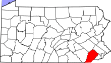
| County | Chester |
| Township | Pocopson |
| Elevation | 194 ft (59 m) |
| Time zone | Eastern (EST) (UTC-5) |
| • Summer (DST) | EDT (UTC-4) |
| Area code(s) | 610 and 484 |
| GNIS feature ID | 1204010[1] |
Lenape is an unincorporated community in Pocopson Township in Chester County, Pennsylvania, United States. Lenape is centered on the intersection of Pennsylvania Route 52 and Pocopson Road west of the Brandywine Creek.[2]
History
A post office called Lenape was established in 1870, and remained in operation until it was discontinued in 1923.[3] The community was named after the Lenape Indians.[4]
References
- ↑ "Lenape". Geographic Names Information System. United States Geological Survey.
- ↑ Chester County, Pennsylvania Highway Map (PDF) (Map). PennDOT. 2012. Retrieved August 22, 2013.
- ↑ "Chester County". Jim Forte Postal History. Retrieved 14 June 2015.
- ↑ Gannett, Henry (1905). The Origin of Certain Place Names in the United States. U.S. Government Printing Office. p. 185.
This article is issued from Wikipedia - version of the 10/15/2016. The text is available under the Creative Commons Attribution/Share Alike but additional terms may apply for the media files.