Lehigh and Susquehanna Railroad
|
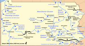
The Lehigh and Susquehanna Railroad connected to Pennsylvania's 1837 Main Line of Public Works, allowing manufactured and bulk goods, especially coal, to be shipped between the Delaware and Susquehanna River valleys | |
| Locale | Northeast Pennsylvania |
|---|---|
| Dates of operation | –1976 |
| Successor | Conrail |
| Track gauge | 4 ft 8 1⁄2 in (1,435 mm) |
The Lehigh and Susquehanna Railroad was founded in 1837 as a shortline railroad by the Lehigh Coal & Navigation Company (LC&N) to bring traffic to its Lehigh Canal. It is today a holding company that leases several important rail corridors in eastern Pennsylvania's anthracite coal region.
History

It began with two short stretches of track: the Ashley Planes cable railway that lifted carloads of coal more than a thousand feet in two miles, and the yard and connecting road between Penobscot (now Mountain Top, Pennsylvania) and the docks on the Head End of the extended Lehigh Canal at White Haven, Pennsylvania. Over the next five decades, the company spearheaded a variety of tough terrain mountain railroading projects and took over management of other shortline joint venture projects. These expansions connected the Lehigh, Schuylkill, Delaware and Susquehanna river valleys, establishing transport corridors through the Pennsylvania Ridge and Valley Appalachians that are still used today.
After several years of planning and politics and armed with easements and rights of ways originating under an 1837 act of the legislature of the Commonwealth of Pennsylvania whose various far-flung and diverse transport and infrastructure projects became known as the Main Line of Public Works the LH&S was founded to develop and manage a route into the rich, easily mined coal fields of the Northern Anthracite Region (lying in and around the Wyoming Valley). Pennsylvania's business and civic leaders aims were to connect coal loading facilities along the Navigations improving the Susquehanna River (acting as the Pennsylvania Canal) to connect the Northern Coal Region at Wilkes-Barre (elevation ca 690 feet (210.3 m)) to the burgeoning industries and ports of the Delaware Valley. Other parts of the Main Line of Public Works were to connect Eastern Pennsylvania to the Susquehanna, and the Susquehanna Valley to the Ohio Valley and Pittsburgh—with their eye on supplying the settlers constantly moving west and the consequent booming population west of the Appalachians.
The Lehigh and Susquehanna developed technologies for various tough mountainous obstacles along their route. Coal would be hauled up a steep two mile incline via their newly built local cable railroad (funicular) leg known as the Ashley Planes to a nearly mile-long segment of standard railroad trackage that traversed the bottom of a hand-hewn purpose-built 75' deep trench (the Solomon Gap) from the Solomon Creek gorge to the LH&S rail yard nearly a 1,000 feet (304.8 m) above[1] in Penobscot, PA (Now Mountain Top, Pennsylvania in Fairview Township, Luzerne County, Pennsylvania).
In a second, later phase of construction, the railroad built a steep double-tracked (called the 'back track') route cutting the difficult grade (at that era, so steep as to be unclimbable by Steam Engines with loaded cars) into the mountainside from the north end of the Solomon Gap. This back track branch line also descended to the Ashley Planes's gathering and staging yard (for returning empty coal hopper cars) via a much longer, more circuitous and winding route descending along a traverse across the slopes of the hillsides through the Greater Wilkes-Barre municipalities of Fairview, Laurel Run, Westminster, Laflin, Yatesville, Suscon, Dupont, Avoca, Moosic, Duryea and Pittston.
With the power available using modern locomotives, this branchline is still heavily traveled and since the 1920s has become the main freight and passenger route connecting the Wyoming and Lehigh Valleys. Today, with motor cars able to take grades unthinkable to locomotives or animal powered wagons, a steep portion of PA Route 309 from Mountaintop to Ashley parallels and uses the upper part of the Ashley Planes right of way on its northwards descent from the Solomon cut. Both branch lines join at the impressively deep Solomon cutting and jointly transited the gap into the Mountain Top railroad staging yard that the Lehigh and Susquehanna Railroad established in the flat terrain of the saddle about two miles from the mine's incline plane rail road, the far end connecting to a steep but manageable grade decent/ascent reaching White Haven on the Lehigh River which mostly follows along the ridgeline forming the drainage divide between the Susquehanna and Lehigh Basins. This short line thus transitions between the Potomac-Tidewater-Chesapeake basin and the Delaware basin
Many area mines fed product over this cable railroad until it was closed as uneconomic in the 1930s. The roadbed from Mountaintop to White Haven is paralleled by Pennsylvania Route 437, and that original part of the rail road was later extended down river through the Lehigh Gorge from White Haven to Mauch Chunk/Jim Thorpe when floods destroyed the extension of the Lehigh Canal in the gorge. Before the flood, planned northern construction was held off while the lines' trackage from Easton on the Delaware to Mauch Chunk below the Lehigh River Gorge was assayed. With the ability to reach their canal head, the railroad was in no hurry to connect its two halves by construction of trackage along the Lehigh gorge until the upstart Lehigh Valley (LV or LVRR) pushed into East Mauch Chunk (now part of Jim Thorpe) and began building up through the gorge on the left bank. Centered in the right bank town of Mauch Chunk the L&S finally moved with alacrity to connect both its halves. The trackage established by the railroad was double-tracked in the severe gradient from the Mountain Top Yardto Laurel Run, and other early trackage extended to Hudson Junction at Miner St. Jct. 1st St in Wilkes-Barre (Moosic)—which connected other railroads and to the Tayor yard and Scranton, Pennsylvania, as well as lower Eastern New York State. The LVRR followed a right away just upslope of the competing line from the exit from the Lehigh Gorge at White Haven all the way northwest to Avoca/Dupont crossing the LH&S near Hudson Junction to its mainline descent along Railroad St., Pittston/Duryea to the Duryea yard but also had a connecting spur which joined the LH&S at Hudson Junction which gave access to both southern lines to the Delaware and Hudson and Erie Railroads operations via the Taylor yard wye.
The famous Summit Hill and Mauch Chunk switchback railway, North America's second operating railroad was transferred to the control of the LH&S by the LC&N parent company in the 1850s along with other southern trackage owned by the mining company, and the whole of LH&S's operations were leased to the Central Railroad of New Jersey (CNJ, also Jersey Central') in the early 1870s. LH&S since has been a holding company, but LC&N/LH&S maintained ownership of the trackage rights until the Conrail consolidations in the 1970s, and the operator throughout was the CNJ. Excepting for its two steep specialty coal railroads: the Ashley Planes and the switchback railway, the routes and road bed established by the line are still in use today in the mountainous terrain of Northeastern Pennsylvania. Both the specialty railroads lived well into the 20th century, with the switchback road being credited as being America's first roller coaster after it was abandoned as a coal haul road but converted to a tourist attraction— a role it had played from its inception.
References
- ↑ GoogleEarth puts trackage through Solomon Gap and Mountain Top Yard at 1634 ft, base at 650-690ish feet. Path and Right of Way compared to 1892 Wilkes-Barre Quadrant USGS maps from http://historical.mytopo.com
- Clint Chamberlin. "LEHIGH AND SUSQUEHANNA DIVISION". North East Rails. Retrieved 14 September 2013.