Amazônia Legal
Amazônia Legal (Portuguese pronunciation: [amaˈzonjɐ leˈɡaw], Legal Amazon) is the largest socio-geographic division in Brazil, containing all 9 states in the Amazon basin. The region was created in 1948 based on studies of the Brazilian government on how to plan the economic and social development of the Amazon region.
Area
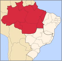
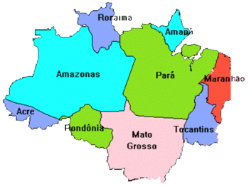
It is officially designated to encompass all seven states of the North Region (Acre, Amapá, Amazonas, Pará, Rondônia, Roraima and Tocantins), as well as part of Mato Grosso in the Center-West Region and most of Maranhão in the Northeast Region. Amazonia Legal is a 5,016,136.3Km2 region with around 24 million inhabitants, in other words 59% of Brazil is part of Amazonia Legal but only 12,34% of the Brazilian population lives there. The administrative unit was initially established by Federal Law No. 5.173 (Art. 2).[1]
Although called Amazonia Legal the region has three different biomes, all the Amazon rainforest biome within Brazil, 37% of the Cerrado biome and 40% of the Pantanal biome[2] The main characteristic of the region is the abundant and tropical vegetation, including large sections of rainforest.
Demographics
A total population of 24.7 million inhabitants lives in the area,[3] including more than 300,000 Indians belonging to more than 170 ethnicities and many traditional extractive communities.
Because of its remoteness, this region was the last to be inhabited by Brazilians of European descent and it still has a very low population density.
See also
- Brazilian Institute of Environment and Renewable Natural Resources
- Regions of Brazil
- Brazil socio-geographic division
References
- ↑ Lei Federal Nº 5.173, de 27 de outubro de 1966. Dispõe sobre o Plano de Valorização Econômica da Amazônia; extingue a Superintendência do Plano de Valorização Econômica da Amazônia (SPVEA), cria a Superintendência do Desenvolvimento da Amazônia (SUDAM), e dá outras providências. Senado Federal, Subsecretaria de Informações. Acesso em 28/08/2012.
- ↑ INSTITUTO SOCIOAMBIENTAL - ISA (Socio Environment Institute). Laboratório de Geoprocessamento. 2009. Amazônia Brasileira 2009 (mapa). Edição especial Programa Áreas Protegidas da Amazônia (ARPA).
- ↑ INSTITUTO BRASILEIRO DE GEOGRAFIA E ESTATÍSTICA (IBGE). 2000. Estimativas populacionais dos municípios em 2009. Acesso em 28/08/2012.
External links
- The various Amazons - Instituto Sociambiental
- Amazônia Legal, on Noticias Da Amazonia (in Portuguese)
- Bolsa Floresta