Le Sourn
| Le Sourn Ar Sorn | |
|---|---|
|
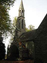
The chapel of Saint-Michel, in Le Sourn | |
 Le Sourn | |
|
Location within Brittany region  Le Sourn | |
| Coordinates: 48°02′37″N 2°59′19″W / 48.0436°N 2.9886°WCoordinates: 48°02′37″N 2°59′19″W / 48.0436°N 2.9886°W | |
| Country | France |
| Region | Brittany |
| Department | Morbihan |
| Arrondissement | Pontivy |
| Canton | Pontivy |
| Intercommunality | Pontivy Communauté |
| Government | |
| • Mayor (2008—2014) | Jean-Luc Oliviero |
| Area1 | 16.05 km2 (6.20 sq mi) |
| Population (1999)2 | 1,843 |
| • Density | 110/km2 (300/sq mi) |
| Time zone | CET (UTC+1) |
| • Summer (DST) | CEST (UTC+2) |
| INSEE/Postal code | 56246 / 56300 |
| Elevation | 46–184 m (151–604 ft) |
|
1 French Land Register data, which excludes lakes, ponds, glaciers > 1 km² (0.386 sq mi or 247 acres) and river estuaries. 2 Population without double counting: residents of multiple communes (e.g., students and military personnel) only counted once. | |
Le Sourn (Breton: Ar Sorn) is a commune in the Morbihan department of Brittany in north-western France.
Demographics
Inhabitants of Le Sourn are called in French Sournais.
See also
References
External links
| Wikimedia Commons has media related to Le Sourn. |
- Official website (French)
- French Ministry of Culture list for Le Sourn (French)
- Map of Le Sourn on Michelin (English)
This article is issued from Wikipedia - version of the 3/15/2016. The text is available under the Creative Commons Attribution/Share Alike but additional terms may apply for the media files.