Lawrence Avenue


Lawrence Avenue is a major east-west thoroughfare in Toronto, Ontario, Canada. It is divided into east and west portions (Lawrence Avenue East and Lawrence Avenue West) by Yonge Street, the dividing line of east-west streets in Toronto.
Route description
The western terminus of Lawrence Avenue is Royal York Road. From there, the road continues as The Westway, a windy arterial road that ends at Martin Grove Road constructed post-World War II to serve the growing Richview neighbourhood development to the south and the Kingsview Village neighbourhood to the north. After only a short stretch in Etobicoke, where it runs through the Humber Heights – Westmount neighbourhood Lawrence crosses the Humber River and enters Weston in the former city of York. East of Weston it enters North York, and passes through the neighbourhoods of Amesbury, Maple Leaf, Glen Park, Lawrence Heights, and Lawrence Manor. Through this section the street is mostly home to low-rise residential, with some retail and office locations.
East of Avenue Road the road enters the Old City of Toronto, and is a major arterial for the North Toronto neighbourhood. This is one of the wealthiest parts of Toronto. Lawrence remains almost wholly residential through this section, with many single family homes. Lawrence Avenue East is interrupted at Bayview Avenue, by the west branch of the Don River. A detour north on Bayview leads to Post Road, and a connection back to Lawrence Avenue on the east side of the valley. This detour runs through The Bridle Path, one of Toronto's most affluent neighbourhoods. East of Leslie Street, Lawrence becomes a principal arterial road, passing through Don Mills. East of the Don River is the Lawrence Avenue exit of the Don Valley Parkway.
Lawrence continues as a six-lane road through most of Scarborough, with many strip malls flanking its sides. Through Scarborough it is the main east-west arterial for a number of neighbourhoods, including Wexford, Bendale, Woburn, and West Hill. The segment east of Morningside Avenue is primarily residential. The road ends at Rouge Hill Drive (then becomes a driveway into a Rouge Beach Park) near the Rouge River, east of Port Union where it hits Lake Ontario.
The Toronto Transit Commission's 52 Lawrence West and 54 Lawrence East (both are the longest bus route in the city), and 162 Lawrence-Donway bus routes provide service along the length of the avenue. The 54A Lawrence East surface route operates from Eglinton Station to Starspray Boulevard near Rouge Park and the 52B Lawrence West surface route operates from Lawrence Station to Westwood Mall Bus Terminal in Mississauga west of Toronto Pearson International Airport via Dixon Road. There are three rapid transit stations; Lawrence at Yonge Street and Lawrence West at Allen Road on Line 1 Yonge–University, and Lawrence East on Line 3 Scarborough, between Kennedy Road and Midland Avenue.
GO Transit has two commuter rail stations on Lawrence Avenue; Rouge Hill,[1] on the Lakeshore East line, and Weston on the Kitchener line.[2]
History
Lawrence Avenue was named for Jacob Lawrence, a tanner and farmer in the area of Yonge Street and Lawrence Avenue.[3] Originally Lawrence Avenue only ran east of Yonge Street, with the road heading west to Weston being named McDougall Avenue[4]
East of Victoria Park Avenue the road was also referred to as 1st Concession Road based on the original survey of the old Township of Scarborough.
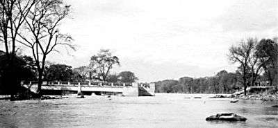
During Hurricane Hazel in 1954, the Lawrence Avenue bridge over the Humber River was washed out when the river's water levels rose heavily as a result of the rainfall.[5] When the Don Valley Parkway was constructed in the 1960s, Lawrence was rebuilt between the Woodbine Avenue allowance, and Victoria Park Avenue, as a "jog eliminator" between the former concession roads of North York and Scarborough Townships. This portion to Kingston Road (former Highway 2), is a minimum of six lanes wide. Lawrence Avenue served as the "Base Line" for the Scarborough Township Survey in the 1800s, and remains a key road in that area.
Lawrence Avenue east of Meadowvale Road in Scarborough was part of Colonel Danforth Trail until the early 1970s.
Landmarks
| Landmark | Cross street | Notes | Image |
|---|---|---|---|
| Sanctuary Park Cemetery | Royal York Road | Opened 1927 and merged from Riverside Cemetery and Westside Cemeteries in 1977. |  |
| St. Philip Anglican Church | Royal York Road |  | |
| Weston GO Station | Weston Road | Opened in 1974 as part of Georgetown Line, it has become a stop along the Union Pearson Express route to Toronto Pearson International Airport in 2015. Nearby was once CPR Weston Station. |  |
| CIBC 750 Lawrence | Dufferin Street | major computer centre, credit card call centre and head office operations built in 1980s |  |
| Lawrence Square Shopping Centre | Allen Road | Former RS Simpson Limited warehouse from the 1950s to 1970s, current mall opened in 1980s. |  |
| Lawrence West subway station | Allen Road | The station lacks internal art work found on Line 1 Yonge–University, but found on exterior wall on the north side of south station. Opened 1978. |  |
| Bathurst Heights Secondary School | Allen Road/Allen Expressway | now John Polanyi Collegiate Institute after being used by Toronto Catholic District School Board (TCDSB) for Dante Alighieri Academy Beatrice Campus and temporary home for Brebeuf College School; built in 1955 for North York Board of Education, building was vacant from 2001 to 2002. | |
| Lawrence Plaza | Bathurst Street | One of the earliest shopping plazas in Toronto built in 1950s | |
| Havergal College | Avenue Road | Private and independent girls school moved to current site in 1926. |  |
| Lawrence Park Collegiate Institute | Avenue Road | Public high school opened in 1936 for Toronto Board of Education (now with Toronto District School Board) |  |
| Lawrence subway station | Yonge Street | Underground bus loop with counter to the normal traffic directions, opened in 1973 | |
| Toronto French School | Bayview Avenue | Private and independent French school housed in Sifton Manor, former home of Sir Clifford Sifton from 1922 to 1947 and acquired by school in 1972. |  |
| Glendon College, York University | Bayview Avenue | Situated in the former home of Edward Rogers Wood built in 1924 and sold 1950; home to York University since 1966. |  |
| Bridle Path | The Bridle Path | Toronto's wealthiest neighbourhood first developed in 1937 by E. P. Taylor |  |
| Edwards Gardens | Leslie Street | Name for former mill operator Rupert E. Edwards opened in 1956 a Metro Toronto owned park |  |
| Don Mills Centre | Don Mills Road | Plaza mall opened 1955, enclosed in 1978 and now open air mall Shops at Don Mills since 2006. |  |
| Don Mills Collegiate Institute | Don Mills Road | Public high school opened in 1959 for North York Board of Education (now with Toronto District School Board) |  |
| Wexford Heights United Church | Warden Avenue | Zion Wexford United Church built 1842 with additions in 1956 and 1961 added |  |
| St. Lawrence Martyr Catholic Church | Birchmount Road | Opened 1959 |  |
| Winston Churchill Collegiate Institute | Kennedy Road | Open 1953 for Township of Scarborough and Scarborough Board of Education (now with Toronto District School Board) | 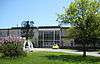 |
| Lawrence East RT station | Kennedy Road | Opened in 1985 and will be closed in 2015 when line re-built. |  |
| David and Mary Thomson Collegiate Institute | Midland Avenue | named after Scarborough's first European (Scottish) born pioneer families. Built for Scarborough Board of Education (now with Toronto District School Board) and to close in 2014 (and demolished after 2015). |  |
| Thomson Memorial Park | Brimley Road | Named after Scarborough's first European (Scottish) born pioneer family and opened in 1960. | 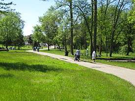 |
| The Scarborough Hospital | McCowan Road | Formerly Scarborough General Hospital opened 1956 |  |
| St. Rose of Lima Catholic Church | McCowan Road |  | |
| Cedarbrae Mall | Markham Road | Outdoor strip plaza opened in 1962 and later enclosed. |  |
| St. Stephen's Presbyterian Church | Scarborough Golf Club Road | Built 1962 and replaced the former Golf Club Road Presbyterian Church |  |
| Sir Oliver Mowat Collegiate Institute | Centennial Road | Public high school opened 1969 for Scarborough Board of Education (now with Toronto District School Board) | |
| Rouge Hill GO Station | Eastern Avenue | Station opened in 1967 and upgraded with current station infrastructure and was in what was once part of Pickering. |  |
References
Major roads, highways and streets in Toronto | |||||||||||
|---|---|---|---|---|---|---|---|---|---|---|---|
| North-south |
| ||||||||||
| East-west |
| ||||||||||
| |||||||||||
| |||||||||||