Sudbrook (stream)
| Sudbrook | |
| Stream | |
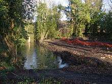
 Sudbrook, near Ham Gate and pond, Richmond Park | |
| Country | United Kingdom |
|---|---|
| Tributaries | |
| - left | Latchmere Stream |
| Source | |
| - location | Dann's Pond, Richmond Park, Greater London |
| - coordinates | 51°25′40.74″N 0°16′47.64″W / 51.4279833°N 0.2799000°W |
| Mouth | |
| - location | Petersham Meadows, River Thames |
| - coordinates | 51°26′55.34″N 0°18′20.88″W / 51.4487056°N 0.3058000°WCoordinates: 51°26′55.34″N 0°18′20.88″W / 51.4487056°N 0.3058000°W |
| Length | 3.8 km (2 mi) |
 Sudbrook outfall on the Thames at Petersham. | |
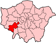
Sudbrook and its tributary, the Latchmere stream, are streams that drain the areas of north Kingston upon Thames, Ham and Petersham following the course of a meander scar in a terrace of the River Thames.
Sudbrook

Sudbrook (from 'South brook') rises at Dann's Pond on relatively high ground in Richmond Park, flowing northwest towards Ham Gate. It flows through a small valley known as Ham Dip and has been dammed and enlarged in two places to form 'Ham Dip Pond' and 'Ham Gate Pond', first mapped in 1861 and 1754 respectively. These were created for the watering of deer.[1] Both ponds are undergoing restoration work including de-silting, due for completion in summer 2013.[2] Sudbrook drains the western escarpment of the hill that, to the east, forms part of the catchment of Beverley Brook and, to the south, the Hogsmill River.

Sudbrook is joined by the Latchmere Stream just beyond Ham Gate Pond. Sudbrook then flows into Sudbrook Park, Petersham, and is culverted for the remainder of its course, discharging into the tidal River Thames to the east of 'River Lane' where the culvert outfall is protected from tidal backflow by a flap valve.
Prior to culverting, Sudbrook used to flow alongside the A307 road and was crossed by a ford at the junction with Sudbrook Lane.[3] The collapse of this culvert in the late 1970s, referred to as the Petersham Hole, caused widespread traffic disruption for over a year.
Latchmere Stream

The name 'Latchmere' derives from 'lache', lazy or slow-moving and 'mere', a marsh or lake.
The Latchmere Stream or Latchmere Brook started as drainage ditches in the Canbury area to the north of Kingston railway station and flows north-east then north, fed from the east by surface runoff from the Richmond Park escarpment and from the west by the slight gradient to the east of the A307 road.[4][5] Now culverted through most of its course, the Latchmere stream emerges on Ham Common, about 50 metres west of Ham Gate outside Richmond Park then flows a short distance before entering the park under the wall and joining Sudbrook by Ham Gate Pond.
From Roman through to Saxon times or later, the watercourses in and to the north of Kingston town centre formed a series of islands formed by a branch of the Hogsmill River and a drainage channel linked to the Latchmere stream.[6][7]
With the increase of urbanisation of Kingston in the early 19th century, the Latchmere ditch served as an open sewer and became a public nuisance and a health hazard: The stench from this ditch, which is an open one, is always bad, but in summer it is beyond words to describe reported the Kingston Board of Guardians on 19 June 1866.[8] This and other open sewers were the cause of serious public health problems, and in the 1890s the old Latchmere Brook, the only source of drinking water for some, was cited as the cause of fatalities through infant diarrhoea and diphtheria.[9] Such open sewers were replaced in the early 20th century.
Expansion of residential housing across former agricultural land has resulted in the Latchmere stream being concealed underground, but its course is revealed during periods of heavy rainfall, is thus the subject of pluvial flood risk management activity.[4]
References
- ↑ McDowall, David (1996). Richmond Park: The Walker's Historical Guide. ISBN 095278470X.
- ↑ "Work starts on more ponds". Friends of Richmond Park. 2012. Retrieved 30 November 2012.
- ↑ "1 HISTORY". Petersham Village, Richmond, Surrey. Retrieved 30 November 2012.
- 1 2 "SURFACE WATER MANAGEMENT PLAN" (pdf). London Borough of Richmond upon Thames and Royal Borough of Kingston upon Thames. 21 August 2009.
- ↑ 'Sheet 006,' in Map of Surrey (Map). 1:10,560. Ordnance Survey. 1871–1882. Retrieved 1 May 2015.
- ↑ "The Hogsmill River : Life and Times". Kingston upon Thames Archaeological Society. Retrieved 30 November 2012.
- ↑ Lindsell, David (8 May 2010). "Archaeologists reveal Kingston's history unearthed in past 40 years". Surrey Comet.
- ↑ "Fever, Filth & Fear The History of Public Health in Kingston" (pdf). Royal Borough of Kingston upon Thames. Retrieved 30 November 2012. line feed character in
|title=at position 20 (help) - ↑ French, Christopher; Warren, Juliet (2004). "Medical officers of health and infant mortality: the case of Kingston upon Thames in the late nineteenth and early twentieth centuries" (PDF). Faculty of Arts and Social Sciences, Kingston University.
| Wikimedia Commons has media related to Sudbrook (stream). |
| Next confluence upstream | River Thames | Next confluence downstream |
| Hogsmill River (south) | Sudbrook (stream) | River Crane, London (north) |