Langtang South
| Langtang South | |
|---|---|
| LGA | |
 Langtang South Location in Nigeria | |
| Coordinates: 8°38′N 9°48′E / 8.633°N 9.800°ECoordinates: 8°38′N 9°48′E / 8.633°N 9.800°E | |
| Country |
|
| State | Plateau State |
| Headquarters | Mabudi |
| Area | |
| • Total | 838 km2 (324 sq mi) |
| Population (2006 census) | |
| • Total | 106,305 |
| Time zone | WAT (UTC+1) |
| 3-digit postal code prefix | 941 |
| ISO 3166 code | NG.PL.LS |
Langtang South is a Local Government Area in Plateau State, Nigeria. Its headquarters are in the town of Mabudi.
It has an area of 838 km² and a population of 106,305 at the 2006 census.
The postal code of the area is 941.[1]
As of July 2014 Hon. Beni Lar represents the Langtang North and Langtang South constituency in the House of Representatives.[2]
See also
- Langtang, town
- Langtang North Local Government Area
Langtang South,Nigeria.
  Langtang, Nigeria is
 classified into two main category or segments, and this categories are:
 (1)Langtang North and
 (2)Langtang South.
The entered Langtang north and Langtang South are well considered to be as one Tribe, known as The Tarok Land.
    The community name
   listed below are some of the Langtang South community that are around the Mabudi Community (The center of Langtang South Lga.
  (1)Telfirm Community,
  (2)Kamkun Community,
  (3)Talgwang "
  (4)Mangwang "
  (5)Sabongida "
  (6)Gamankai  "
  (7)Nagani    "
  (8)Ubang    "
  (9)Gina-Rumbu "
  (10)Dadinkowa "
  (11)Zambang "
and(12)Lashel "etc.
- ↑ "Post Offices- with map of LGA". NIPOST. Retrieved 2009-10-20.
- ↑ Hamza Idris; Yahaya Ibrahim (2014-07-15). "Nigeria: 38 Killed As Boko Haram Attacks Borno Village". Daily Trust - AllAfrica. Retrieved 2014-07-18.
State capital: Jos | ||
| LGAs | 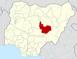 | |
This article is issued from Wikipedia - version of the 10/22/2015. The text is available under the Creative Commons Attribution/Share Alike but additional terms may apply for the media files.