Landis Mill Covered Bridge
| Landis Mill Covered Bridge | |
|---|---|
 | |
| Coordinates | 40°04′05″N 76°20′41″W / 40.0680°N 76.3448°WCoordinates: 40°04′05″N 76°20′41″W / 40.0680°N 76.3448°W |
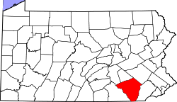
| Locale | Lancaster County, Pennsylvania, United States |
| Official name | Little Conestoga #1 Bridge |
| Characteristics | |
| Design | single span, double pyramidal-shaped Burr-type truss, multiple king post truss |
| Total length | 53 feet (16.2 m) |
| History | |
| Constructed by | Elias McMellen |
| Construction begin | 1873 |
 | |
 | |
The Landis Mill Covered Bridge is a covered bridge that spans the Little Conestoga Creek in Lancaster County, Pennsylvania, United States. A county-owned and maintained bridge, its official designation is the Little Conestoga #1 Bridge.[1] The bridge, built in 1873 by Elias McMellen, is today surrounded by a development, shopping center, and highways on the boundary of Lancaster, Pennsylvania.[2] At 53 feet (16.2 m), it is the shortest covered bridge in the county.[3]
The bridge has a single span, wooden, double pyramidal-shaped Burr-type trusses and multiple king post truss design with the addition of steel hanger rods. It is the only bridge in the county to use this design. The deck is made from oak planks.[1] It is painted red, the traditional color of Lancaster County covered bridges, on both the inside and outside. Both portals to the bridge are painted in red with white trim.
The bridge's WGCB Number is 38-36-16. In 1980 it was added to the National Register of Historic Places as structure number 80003526.[4] It is located at 40°4′4.8″N 76°20′41.4″W / 40.068000°N 76.344833°W (40.06800, -76.34483). It can be found northwest of Lancaster on Shreiner Road one block West of the Park City Center shopping mall.[3][5][6]
History
Landis Mill Covered Bridge was built in 1873 by Elias McMellen at a cost of $969. McMellen, who built many of Lancaster's covered bridges using the Burr arch truss, chose to build this short bridge using a simpler design with multiple kingpost trusses and, instead of Burr arches, pyramidal-shaped trusses to add additional support.[3] The bridge has remained despite the development of the surrounding countryside.
Dimensions[1]
- Length: 41 feet (12.5 m) span and 53 feet (16.2 m) total length[2]
- Width: 13 feet (4.0 m) clear deck and 15 feet (4.6 m) total width[2]
- Overhead clearance: 12 feet (3.7 m)
- Underclearance: 8 feet (2.4 m)
Gallery
 One of the approaches to the bridge
- Side view
 Three quarters view
 Inside of the bridge showing the Multiple kingpost truss and the Burr-type pyramidal-shaped support truss design
 Closeup of the truss joint
 The bridge identification sign inside the bridge
 One of the inside corners of the bridge with the roof
References
- 1 2 3 "Landis Mill Covered Bridge". Lancaster County, PA Government Portal. County of Lancaster, Pennsylvania. 2001-10-20. Retrieved 2006-07-07.
- 1 2 3 Dr. Roger A. McCain. "Landis Mill Bridge". A Guide to Old Covered Bridges of Southeastern Pennsylvania and nearby areas. Retrieved 2006-08-03.
- 1 2 3 "Landis Mill Covered Bridge". Lancaster County Pennsylvania Dutch Country Official Visitors Center. Pennsylvania Dutch Convention & Visitors Bureau. 2006. Retrieved 2006-07-07.
- ↑ "PENNSYLVANIA - Lancaster County". National Register of Historic Places. Retrieved 2007-03-20.
- ↑ Bickel, Hank (2005-06-23). "Landis Bridge". Covered Bridges of the Northeast USA. Retrieved 2006-08-04.
- ↑ Travis, Dale. "38-36-16". Round Barns & Covered Bridges. Retrieved 2006-08-08.
| Topics |   | |
|---|---|---|
| Lists by county |
| |
| Lists by city | ||
| Other lists | ||
| ||