Lam Plai Mat District
| Lam Plai Mat ลำปลายมาศ | |
|---|---|
| Amphoe | |
|
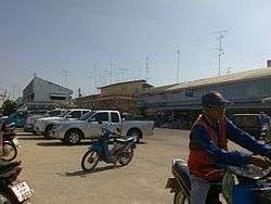
Neighborhood near Lam Plai Mat railway station | |
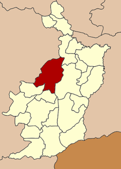 Amphoe location in Buriram Province | |
| Coordinates: 15°1′31″N 102°50′19″E / 15.02528°N 102.83861°ECoordinates: 15°1′31″N 102°50′19″E / 15.02528°N 102.83861°E | |
| Country | Thailand |
| Province | Buriram |
| Area | |
| • Total | 802.9 km2 (310.0 sq mi) |
| Population (2005) | |
| • Total | 132,277 |
| • Density | 164.7/km2 (427/sq mi) |
| Time zone | ICT (UTC+7) |
| Postal code | 31130 |
| Geocode | 3110 |
Lam Plai Mat (Thai: ลำปลายมาศ, pronounced [lām plāːj mâːt]) is a district (amphoe) of Buriram Province, northeastern Thailand.
Geography
Neighboring districts are (from the northeast clockwise) Khu Mueang, Mueang Buriram, Chamni, Nong Hong of Buriram Province, Huai Thalaeng, Chum Phuang, and Lam Thamenchai of Nakhon Ratchasima Province.
Administration
The district is divided into 16 sub-districts (tambon), which are further subdivided into 220 villages (muban). There are two townships (thesaban tambon): Lam Plai Mat covers parts of the tambon Lam Plai Mat, Nong Khu and Hin Khon; Thamenchai covers parts of tambon Thamenchai and Nong Bua Khok. There are a further 15 tambon administrative organizations (TAO).
| No. | Name | Thai name | Villages | Pop. | |
|---|---|---|---|---|---|
| 1. | Lam Plai Mat | ลำปลายมาศ | 17 | 10,587 | |
| 2. | Nong Khu | หนองคู | 14 | 8,405 | |
| 3. | Salaeng Phan | แสลงพัน | 16 | 9,293 | |
| 4. | Thamen Chai | ทะเมนชัย | 17 | 9,245 | |
| 5. | Talat Pho | ตลาดโพธิ์ | 9 | 5,603 | |
| 6. | Nong Kathing | หนองกะทิง | 11 | 7,264 | |
| 7. | Khok Klang | โคกกลาง | 16 | 9,161 | |
| 8. | Khok Sa-at | โคกสะอาด | 16 | 10,009 | |
| 9. | Mueang Faek | เมืองแฝก | 16 | 10,074 | |
| 10. | Ban Yang | บ้านยาง | 12 | 8,203 | |
| 11. | Phathairin | ผไทรินทร์ | 19 | 9,751 | |
| 12. | Khok Lam | โคกล่าม | 12 | 7,533 | |
| 13. | Hin Khon | หินโคน | 16 | 9,897 | |
| 14. | Nong Bua Khok | หนองบัวโคก | 13 | 7,913 | |
| 15. | Bu Pho | บุโพธิ์ | 8 | 4,469 | |
| 16. | Nong Don | หนองโดน | 8 | 4,870 |
References
This article is issued from Wikipedia - version of the 10/1/2016. The text is available under the Creative Commons Attribution/Share Alike but additional terms may apply for the media files.