Lake Constance
| Lake Constance Bodensee | |
|---|---|
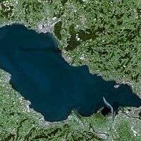
 satellite image | |
 map | |
| Location | Germany, Switzerland, Austria |
| Coordinates | 47°35′N 9°28′E / 47.583°N 9.467°ECoordinates: 47°35′N 9°28′E / 47.583°N 9.467°E |
| Primary inflows | Rhine |
| Primary outflows | Rhine |
| Catchment area | 11,500 km2 (4,400 sq mi) |
| Basin countries | Germany, Switzerland, Austria |
| Max. length | 63 km (39 mi) |
| Max. width | 14 km (8.7 mi) |
| Surface area | 571 km2 (220 sq mi) |
| Average depth | 90 m (300 ft) |
| Max. depth | 251 m (823 ft) |
| Water volume | 51.4 km3 (12 cu mi) |
| Residence time | 4.3 years |
| Surface elevation | 395 m (1,296 ft) |
| Frozen | 1795, 1830, 1880 (partial), 1963 |
| Islands | Mainau, Reichenau, Lindau |
| Sections/sub-basins | Obersee, Überlinger See; Untersee, Zeller See, Gnadensee |
| Settlements | see list |
Lake Constance (German: Bodensee) is a lake on the Rhine at the northern foot of the Alps, and consists of three bodies of water: the Obersee ("upper lake"), the Untersee ("lower lake"), and a connecting stretch of the Rhine, called the Seerhein.
The lake is situated in Germany, Switzerland and Austria near the Alps. Its shorelines lie in the German states of Bavaria and Baden-Württemberg, the Austrian state of Vorarlberg, and the Swiss cantons of Thurgau, St Gallen and Schaffhausen. The river Rhine flows into the lake from the south, with its original course forming the Austro-Swiss border, and has its outflow of the "Lower Lake" where - except from Schaffhausen, see above - it forms the German-Swiss border until the city Basel.
Description
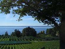
Freshwater Lake Constance is central Europe's third largest, after Lake Balaton and Lake Geneva. It is 63 km (39 mi) long, and at its widest point, nearly 14 km (8.7 mi). It covers approximately 571 km2 (220 sq mi),[1] and is 395 m (1,296 ft) above sea level. The greatest depth is 252 metres (827 ft) in the middle of the eastern part (Obersee). Its volume is approximately 10×109 m3 (13×109 cu yd). The lake has four parts: the main section, called Obersee, 476 km2 (184 sq mi); the north section, Überlinger See, 61 km2 (24 sq mi); the west section, Untersee, 63 km2 (24 sq mi); and the northwest section, the Zeller See and Gnadensee. The regulated Rhine flows into the lake in the southeast, through the Obersee, the city of Konstanz and the Untersee, and flows out near Stein am Rhein. Lake Constance provides fresh water to many cities in south Germany. The culminating point of the lake's drainage basin is the Tödi at 3,614 metres above sea level.[2]
The lake itself is an important drinking water source for southwestern Germany, called Bodensee-Wasserversorgung ("Lake Constance Water Supply").[3] Car ferries link Romanshorn to Friedrichshafen, and Konstanz to Meersburg.
History
Lake Constance was formed by the Rhine Glacier during the ice age and is a zungenbecken lake. The Rhine, the Bregenzer Ache, and the Dornbirner Ache carry sediments from the Alps to the lake, thus gradually decreasing the depth and coastline extension of the lake in the southeast.
Lake Constance was first mentioned by the Roman geographer Pomponius Mela about 43 AD. He noted that the Rhine flows through two lakes, and gave them the Latin names Lacus Venetus (Obersee) and Lacus Acronius (Untersee). Pliny the Elder used the name Lacus Brigantinus, after the Roman city of Brigantium (today Bregenz). The lake is also colloquially known as the Swabian Sea[4] (das schwäbische Meer).
The lake was frozen in the years 1077 (?), 1326 (partial), 1378 (partial), 1435, 1465 (partial), 1477 (partial), 1491 (partial?), 1517 (partial), 1571 (partial), 1573, 1600 (partial), 1684, 1695, 1709 (partial), 1795, 1830, 1880 (partial), and 1963.
Approximately 1,000 tonnes (1,100 short tons) of fish were caught by 150 professional fishermen in 2001 which was below the previous ten year average of 1,200 tonnes (1,300 short tons) per year. The Lake Constance trout (Salmo trutta) was almost extinct in the 1980s due to pollution, but thanks to protective measures they have made a significant return. Lake Constance was the home of the now extinct species of trout Salvelinus profundus,[5] as well as of the Lake Constance whitefish (Coregonus gutturosus).[6]
Name
After the Council of Constance, the Latin-speaking Catholic world gave the lake its current international name. It was derived from the city of Konstanz, that, in turn, was named after a Roman emperor (either Constantius Chlorus or his grandson Constantius II). The German name, Bodensee, derives from the town of Bodman, situated at a nearby branch of the lake some 8 km northwest of Konstanz.
International borders
Lake Constance is the only area in Europe where no borders exist, because there is no legally binding agreement as to where the borders lie between Switzerland, Germany and Austria.[7] However, Switzerland holds the view that the border runs through the middle of the lake, Austria is of the opinion that the contentious area belongs to all the states on its banks, and Germany holds an ambiguous opinion. Legal questions pertaining to ship transport and fishing are regulated in separate treaties.
Naturally, disputes arise. One concerns a houseboat which was moored in two states (ECJ c. 224/97 Erich Ciola); another concerns the rights to fish in the Bay of Bregenz. In relation to the latter, an Austrian family was of the opinion that it alone had the right to fish in broad portions of the bay. However, this was accepted neither by the Austrian courts nor by the organs and courts of the other states.[8]
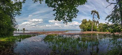
Recent floods
- A 100-year flood around June 1999 (Pfingsthochwasser 1999) raised the level about 2 metres above normal, flooding harbors and many shoreline buildings and hotels.
- In late August 2005, heavy rain raised the level by more than 70 cm in a few days. The rains caused widespread flooding and washed out highways and railroads.
Islands in the lake
The three major islands are:
These are all of the islands and former islands in Lake Constance, listed from east to west:
| Island | Area (m²) | Population | Municipality | Country | Coordinates | |
|---|---|---|---|---|---|---|
| 1 | Galgeninsel | peninsula since 19th century | - | Lindau (Reutin district) | Germany | |
| 2 | Hoy | 53 | - | Lindau (Reutin district) | Germany | |
| 3 | Lindau | 680,000 | 3,000 | Lindau (Island district) | Germany | |
| 4 | Wasserburg | peninsula since 1720 | 27 | Wasserburg (Island district) | Germany | |
| 5 | Mainau | 447,584 | 185 | Konstanz (Litzelstetten district) | Germany | |
| 6 | Dominikanerinsel | 18,318 | 21 | Konstanz (Altstadt district) | Germany | |
| 7 | Mittlerer Langbohl | 31,254 | - | Konstanz (Industriegebiet district) | Germany | |
| 8 | Triboldingerbohl | 135,570 | - | Konstanz (Industriegebiet district) | Germany | |
| 9 | Reichenau | 4,300,000 | 3.200 | Reichenau (Niederzell|Mittelzell|Oberzell) | Germany | 47°41′40″N 09°03′48″E / 47.69444°N 9.06333°E |
| 10 | Liebesinsel | 300 | - | Radolfzell (Mettnau district) | Germany | |
| 11 | Werd | 15,854 | 9 | Eschenz (Untereschenz district) | Switzerland | |
| 12 | Mittleres Werdli | 4,000 | - | Stein am Rhein | Switzerland | |
| 13 | Unteres Werdli | 6,000 | - | Stein am Rhein | Switzerland | |
| Lake Constance Islands | 5,637,079 | 6,400 | 6 municipalities |
Towns and cities at the lake


Austria
Germany
From the entry of the Rhine, on the northern or right shore:
- On the Upper Lake (Obersee) and Überlinger See
- Konstanz with suburbs
- Wallhausen
- Dingelsdorf
- Litzelstetten
- On the lower lake (Untersee)
- Reichenau (including the island with same name)
- Allensbach (on Gnadensee)
- Radolfzell (on Zellersee)
- Moos
- Gaienhofen
- Öhningen
Switzerland
From the entry of the Rhine, on the southern or left shore:
- On the Upper Lake (Obersee)
- Altenrhein, St. Gallen
- Rorschach, St. Gallen
- Horn, Thurgau
- Steinach, St. Gallen
- Arbon, Thurgau (as all the following)
- Frasnacht
- Egnach
- Romanshorn
- Uttwil
- Kesswil
- Güttingen
- Altnau
- Landschlacht
- Münsterlingen
- Bottighofen
- Kreuzlingen (and Konstanz, Germany)
- On the Rhine
- On the Lower Lake (Untersee)
See also
| Wikimedia Commons has media related to Lake Constance. |
- Überlingen mid-air collision
- Württembergischer Yacht Club
- Lake Constance is also the title of a track from Mike Oldfield's The Millennium Bell album
- Obersee (Lake Constance)
References
- ↑ Image #432, Flying Camera Satellite Images 1999, Lloyd Reeds Map Collection, McMaster University Library.
- ↑ 1:25,000 topographic map (Map). Swisstopo. Retrieved 2014-07-27.
- ↑ "Bodensee-Wasserversorgung", German language Wikipedia.
- ↑ Gordon McLachlan. The Rough Guide to Germany. Rough Guides Ltd. London, 2004. ISBN 1-84353-293-X.
- ↑ IUCN Red list
- ↑ Red List - Volume 1: Vertebrates (2009) - General assessment for the vertebrate groups
- ↑ Daniel-Erasmus Kahn (2004). Die deutschen Staatsgrenzen: rechtshistorische Grundlagen und offene Rechtsfragen ("The German national borders: legal-historical foundations and open legal questions"). Oxford University Press. ISBN 9783161484032.
- ↑ David Mark and Barry Smith, et al., Bizarre Shapes: 100 Geographic Monsters.
Literature
- Rolf Zimmermann: A look at Lake Constance. Stadler Verlagsgesellschaft mbH. Konstanz 2004. ISBN 3-7977-0507-7. (Pictures and texts of the cities around Lake Constance).
External links
| Wikivoyage has a travel guide for Lake Constance. |
- Bodensee-Hochwasser (German) waterlevels
- Internationale Bodenseekonferenz
- Regio Bodensee Statistics
- Lake Constance: pictures
- Photos of Lake Constance
- Bibliography on Water Resources and International Law Peace Palace Library
- GrenzRaumSee: A project from the Ludwig-Uhland-Institut für Empirische Kulturwissenschaft (Ludwig-Uhland-Department of European Ethnology / Empirical Cultural Science) of the University of Tübingen
- Lake Constance/Bodensee Lessons learned managing the lake
- Lake Constance Accommodation
- Tourist Information Lake Constance
- Karl Heinz Burmeister: Lake Constance in German, French and Italian in the online Historical Dictionary of Switzerland.
- Nixdorf, B.; et al. (2004), "Bodensee" (PDF), Dokumentation von Zustand und Entwicklung der wichtigsten Seen Deutschlands (in German), Berlin: Umweltbundesamt, p. 4
Lakes of Switzerland | ||
|---|---|---|
| Major lakes |
|  |
| Lists | ||