Lajes do Pico
| Lajes do Pico | |||
| Municipality (Concelho) | |||
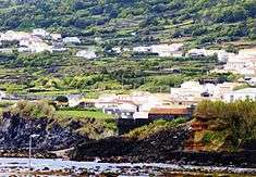 The medieval fort of Santa Catarina, with the hilltop neighborhood of Almagreia; one of the historical buildings in the municipality of Lajes do Pico | |||
|
|||
| Official name: Concelho das Lajes do Pico | |||
| Name origin: lajes, Portuguese for tough rock | |||
| Country | |||
|---|---|---|---|
| Autonomous Region | |||
| Island | Pico | ||
| Civil Parishes | Lajes do Pico, Peidade, Ribeiras, Ribeirinha, São João | ||
| Landmark | Pico | ||
| Center | Lajes do Pico | ||
| - elevation | 350 m (1,148 ft) | ||
| - coordinates | 38°23′49″N 28°13′56″W / 38.39694°N 28.23222°WCoordinates: 38°23′49″N 28°13′56″W / 38.39694°N 28.23222°W | ||
| Highest point | Mount Pico | ||
| - elevation | 2,351 m (7,713 ft) | ||
| - coordinates | 38°28′6″N 28°23′56″W / 38.46833°N 28.39889°W | ||
| Lowest point | Sea level | ||
| - location | Atlantic Ocean | ||
| - elevation | 0 m (0 ft) | ||
| Area | 155.31 km2 (60 sq mi) | ||
| - water | .11 km2 (0 sq mi) | ||
| - urban | 5.03 km2 (2 sq mi) | ||
| Population | 4,711 (2011) | ||
| Density | 30/km2 (78/sq mi) | ||
| Settlement | c. 1406 | ||
| - Municipality | c. 1501 | ||
| LAU | Câmara Municipal | ||
| - location | Rua de São Francisco | ||
| - elevation | 72 m (236 ft) | ||
| - coordinates | 38°23′59″N 28°15′7″W / 38.39972°N 28.25194°W | ||
| President | Roberto Manuel Medeiros da Silva (PS) | ||
| Municipal Chair | Cláudio Lopes (PPD/PSD) | ||
| Timezone | Azores (UTC-1) | ||
| - summer (DST) | Azores (UTC0) | ||
| Postal Zone | 9930-135 | ||
| Area Code & Prefix | (+351) 292 XXX-XXXX | ||
| Demonym | Lajense | ||
| Patron Saint | Nossa Senhora de Lourdes | ||
| Municipal Holidays | 29 June | ||
 Location of the municipality of Lajes in the archipelago of the Azores | |||
| Wikimedia Commons: Lajes do Pico (Azores) | |||
| Statistics: Instituto Nacional de Estatística[1] | |||
| Website: http://www.municipio-lajes-do-pico.pt/ | |||
| Geographic detail from CAOP (2010)[2] produced by Instituto Geográfico Português (IGP) | |||
.png)
Lajes do Pico (Portuguese pronunciation: [ˈlaʒɨʒ ðu ˈpiku]) is a municipality in the southern part of the Azores. The municipality is located is on the southern part of the Pico Island. The population in 2011 was 4,711,[3] in an area of 155.31 km².[4] It is bordered by Madalena to the west and by São Roque do Pico to the north.
History
The history of this municipality can be traced back to 1460, when Fernão Álvares Evangelho built his residence in the area that began to be known as Penendo Negro, in Enseada do Castelete, an area south of the village of Lajes. Due to the necessity of potable water, he built his home alongside a ravine outside of town, that for many years was known as Ribeira de Fernando Álvares.
Geography
The six civil parishes form the municipality of Lajes do Pico, with their own local authority, including:
- Calheta de Nesquim
- Lajes do Pico
- Piedade
- Ribeiras
- Ribeirinha
- São João
References
- ↑ INE, ed. (2010), Censos 2011 - Resultadas Preliminares [2011 Census - Preliminary Results] (in Portuguese), Lisbon, Portugal: Instituto Nacional de Estatística, retrieved 1 January 2012
- ↑ IGP, ed. (2010), Carta Administrativa Oficial de Portugal (in Portuguese), Lisbon, Portugal: Instituto Geográfico Português, retrieved 1 January 2012
- ↑ Instituto Nacional de Estatística
- ↑ Eurostat
| Corvo | ||
|---|---|---|
| Faial | ||
| Flores | ||
| Graciosa | ||
| Pico | ||
| Santa Maria | ||
| São Jorge | ||
| São Miguel | ||
| Terceira | ||