La Sila
| Sila | |
|---|---|
| La Sila | |
 | |
| Highest point | |
| Peak | Botte Donato |
| Elevation | 1,928 m (6,325 ft) |
| Coordinates | 39°17′5.02″N 16°26′49.53″E / 39.2847278°N 16.4470917°E |
| Geography | |
| Country | Italy |
| Region | Calabria |
| Provinces | Cosenza, Crotone and Catanzaro |
| Range coordinates | 39°22′N 16°30′E / 39.37°N 16.5°ECoordinates: 39°22′N 16°30′E / 39.37°N 16.5°E |
La Sila, also spelled Sila, is the name of the mountainous plateau and historic region located in Calabria, southern Italy.
Geography
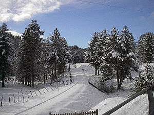
The Sila occupies part of the provinces of Cosenza, Crotone and Catanzaro, and is divided (\from north to south) into the sub-ranges Sila Greca, Sila Grande and Sila Piccola ("Greek", "Greater" and "Lesser Sila", respectively). The highest peaks are the Botte Donato (1,928 m), in the Sila Grande, and Monte Gariglione (1,764 m) in the Sila Piccola. The Sila houses the eponymous national park, the Parco Nazionale della Sila, formerly called National Park of Calabria; it was created in 2002.
History
The first known settlers of the Sila plateau were the Bruttii, an ancient tribe of shepherds and farmers. After the destruction of the Greek city of Sybaris in 510 BC, Rome began to extend its sphere of influence over Calabria, Sila included to the extent that any outside rule affected these mountains. Later it was nominally occupied in turn by the Ostrogoths, the Byzantines and, from the 11th century, the Italo-Normans. The latter favoured the creation of several monasteries, like the Matina of San Marco Argentano, the Sambucina at Luzzi and the Florense Abbey at San Giovanni in Fiore, founded by Joachim of Fiore.
In 1448-1535 immigrants from Albania settled the area towards the Ionian Sea, creating the communities of Sila Greca ("Greek Sila").[1]
After the annexation to the Kingdom of Italy (late 19th century), Sila remained a base of brigandage. New routes were opened to reduce the isolation of the mountain centres, which was dramatic especially in winter: these included the Paola-Cosenza-Crotone road, and specialised mountain railways such as the Cosenza-Camigliatello Silano-San Giovanni in Fiore narrow-gauge line (now operating only for tourist special excursions), operated by the Ferrovie Calabro Lucane, and the Paola-Cosenza rack railway, operated by Ferrovie dello Stato.
The 1949 film The Wolf of the Sila was set in the area, and much of it was shot on location.
Today several centres, such as Camigliatello and Palumbo Sila, are becoming tourist resorts.
References
External links
| Wikimedia Commons has media related to Sila. |