La Junta, Colorado
| La Junta, Colorado | ||
|---|---|---|
| Municipality | ||
|
Woodruff Block, built 1892. 1985 photo, Historic American Buildings Survey. | ||
| ||
 Location in Otero County and the State of Colorado | ||
| Coordinates: 37°58′53″N 103°32′51″W / 37.98139°N 103.54750°WCoordinates: 37°58′53″N 103°32′51″W / 37.98139°N 103.54750°W | ||
| Country |
| |
| State |
| |
| County | Otero County Seat[1] | |
| Incorporated | April 23, 1881[2] | |
| Government | ||
| • Type | Home Rule Municipality[1] | |
| • Mayor | Lynn Horner | |
| • City Manager | Rick Klein | |
| • City Council | Jim Goodwin, Betty Velasquez, Frank McKenzie, Jeffri Pruyn, Ed Vela, Roger Roath | |
| • City Attorney | Phil Malouff | |
| • Police Chief | G. Todd Quick | |
| Area | ||
| • Total | 2.9 sq mi (7.4 km2) | |
| • Land | 2.9 sq mi (7.4 km2) | |
| • Water | 0 sq mi (0 km2) | |
| Elevation[3] | 4,078 ft (1,243 m) | |
| Population (2010) | ||
| • Total | 7,077 | |
| • Density | 2,609.7/sq mi (1,022.7/km2) | |
| Time zone | Mountain (MST) (UTC-7) | |
| • Summer (DST) | MDT (UTC-6) | |
| ZIP code[4] | 81050 | |
| Area code(s) | 719 | |
| FIPS code | 08-42110 | |
| GNIS feature ID | 0204829 | |
| Website | City of La Junta, Colorado | |


La Junta is the Municipality that is the county seat and the most populous municipality of Otero County, Colorado, United States.[5] The city population was 7,077 at the 2010 United States Census. La Junta is located on the Arkansas River in southeastern Colorado east of Pueblo.
History
La Junta (Spanish for "the junction")[6] was named for the fact it rested at the intersection of the Santa Fe Trail and a pioneer road to Pueblo.[7] The town developed near Bent's Post, a fur trading post of the 19th century.
During World War II, La Junta had an Army Air Force Training Base outside town. An Air Force detachment of the Strategic Air Command remained there until modern flight simulators developed in the 1980s rendered live flight unnecessary for pilot training maneuvers. At least one military aircraft crashed close by during such training maneuvers.[8]
The airport, located 5 miles (8.0 km) north of La Junta, has 77 acres (31 ha) of tarmac and two runways which are still in use. One runway (east-west) is 6,851 feet (2,088 m) long and the other is 5,800 feet (1,800 m). .

The Caboose (pictured here) is the drive-through for the State Bank, which was established in 1893. The bank has been remodeled with antiques, including a teller line from the late 1890s.
Location filming in la junta
The Terrence Malick film Badlands (1973), starring Martin Sheen and Sissy Spacek, and Richard Fleischer's Mr. Majestyk (1974), starring Charles Bronson, were both filmed in and around La Junta.
In 1979, the first episodes of the CBS western miniseries The Chisholms, starring Robert Preston, were filmed near La Junta.
Geography and climate
La Junta is located at 37°58′53″N 103°32′51″W / 37.98139°N 103.54750°W (37.981333, -103.547540).[9] According to the United States Census Bureau, the city has a total area of 2.8 square miles (7.3 km2), all of it land. The area is high plains terrain, dry with short grass prairie and sagebrush, and is part of the Southwestern Tablelands ecological region. This area of Colorado is often the warmest. Summer brings numerous days above 100 °F (38 °C). On July 20, 2005, many cities in this region broke or tied heat records. La Junta reached 107 °F (42 °C) with an overnight low of 87 °F (31 °C).[10] However, the all-time record high for La Junta occurred on July 20, 1998 with a temperature of 113 °F (45 °C).[11]
| Climate data for La Junta Municipal Airport (1981–2010) | |||||||||||||
|---|---|---|---|---|---|---|---|---|---|---|---|---|---|
| Month | Jan | Feb | Mar | Apr | May | Jun | Jul | Aug | Sep | Oct | Nov | Dec | Year |
| Average high °F (°C) | 45.5 (7.5) |
49.3 (9.6) |
60.0 (15.6) |
68.6 (20.3) |
78.3 (25.7) |
88.9 (31.6) |
94.3 (34.6) |
91.4 (33) |
83.3 (28.5) |
70.2 (21.2) |
56.3 (13.5) |
45.0 (7.2) |
69.3 (20.7) |
| Average low °F (°C) | 17.4 (−8.1) |
21.1 (−6.1) |
29.5 (−1.4) |
37.6 (3.1) |
47.9 (8.8) |
57.4 (14.1) |
63.0 (17.2) |
61.5 (16.4) |
52.0 (11.1) |
38.6 (3.7) |
26.3 (−3.2) |
17.5 (−8.1) |
39.2 (4) |
| Average precipitation inches (mm) | 0.28 (7.1) |
0.35 (8.9) |
0.81 (20.6) |
1.31 (33.3) |
1.60 (40.6) |
1.31 (33.3) |
1.85 (47) |
1.52 (38.6) |
0.81 (20.6) |
0.83 (21.1) |
0.38 (9.7) |
0.27 (6.9) |
11.34 (288) |
| Average snowfall inches (cm) | 3.3 (8.4) |
3.1 (7.9) |
4.7 (11.9) |
2.0 (5.1) |
0.7 (1.8) |
0.1 (0.3) |
0.0 (0) |
0.0 (0) |
0.2 (0.5) |
0.7 (1.8) |
2.8 (7.1) |
2.9 (7.4) |
21.2 (53.8) |
| Source: NOAA[12] | |||||||||||||
Demographics
| Historical population | |||
|---|---|---|---|
| Census | Pop. | %± | |
| 1890 | 1,439 | — | |
| 1900 | 2,513 | 74.6% | |
| 1910 | 4,154 | 65.3% | |
| 1920 | 4,964 | 19.5% | |
| 1930 | 7,193 | 44.9% | |
| 1940 | 7,040 | −2.1% | |
| 1950 | 7,712 | 9.5% | |
| 1960 | 8,026 | 4.1% | |
| 1970 | 8,205 | 2.2% | |
| 1980 | 8,338 | 1.6% | |
| 1990 | 7,637 | −8.4% | |
| 2000 | 7,568 | −0.9% | |
| 2010 | 7,077 | −6.5% | |
| Est. 2015 | 6,951 | [13] | −1.8% |
There were 7,568 people, 2,977 households, and 1,964 families residing in the city. The population density was 2,652.0 people per square mile (1,025.3/km²). There were 3,277 housing units at an average density of 1,148.3 per square mile (443.9/km²). The racial makeup of the city was 74.22% White, 1.22% African American, 1.77% Native American, 0.86% Asian, 0.13% Pacific Islander, 18.33% from other races, and 3.48% from two or more races. Hispanic or Latino of any race were 43.60% of the population.
There were 2,977 households out of which 33.7% had children under the age of 18 living with them, 47.0% were married couples living together, 14.7% had a female householder with no husband present, and 34.0% were non-families. 30.9% of all households were made up of individuals and 15.0% had someone living alone who was 65 years of age or older. The average household size was 2.44 and the average family size was 3.06.
In the city the population was spread out with 27.1% under the age of 18, 10.4% from 18 to 24, 24.6% from 25 to 44, 21.4% from 45 to 64, and 16.6% who were 65 years of age or older. The median age was 36 years. For every 100 females there were 89.2 males. For every 100 females age 18 and over, there were 84.1 males.
The median income for a household in the city was $29,002, and the median income for a family was $36,398. Males had a median income of $26,325 versus $21,324 for females. The per capita income for the city was $14,928. About 16.8% of families and 21.4% of the population were below the poverty line, including 31.4% of those under age 18 and 10.0% of those age 65 or over.
Arts and culture
Attractions
- Bent's Old Fort National Historic Site, an important trading post along the Santa Fe Trail, is northeast of La Junta.
- Koshare Indian Museum, housed at Otero Junior College, holds a collection of Native American artifacts. The Koshare Indian museum hosts a unique Boy Scout/Explorer program which trains the Scouts in both Indian dance and costumes. The Scouts give dance performances during the summer and also host many other Scout troops passing through the area.
- Purgatoire River track site, one of the largest dinosaur track sites in North America, is south of La Junta.
- Picketwire Center for Performing Arts, home of the local theater company.
Government
Politics
- Mayor: Lynn Horner
- City Council: Eugene Mestas, Betty Velasquez, Jeffri Pruyn, Bob Friedenberger, Roger Roath, Frank McKenzie.
- City Manager: Rick Klein
- City Attorney: Phil Malouff
- Police Chief: G. Todd Quick
- Fire Chief: Aaron Eveatt
Media
The city is served by a daily newspaper, The Tribune-Democrat.
Infrastructure
Transportation
La Junta, until recently, had a railroad yard for assembling freight trains for the climb over Raton Pass. BNSF runs freight trains between Denver and Kansas/Texas via La Junta. The sole remaining major train crossing Raton Pass today is the daily Southwest Chief, in both directions, between Los Angeles and Chicago.
Bus service is provided daily eastward towards Wichita, Kansas and westward towards Pueblo, Colorado by BeeLine Express (subcontractor of Greyhound Lines).[16][17]
U.S. Highway 50 travels through La Junta, approaching from Pueblo to the northwest and continuing eastward towards Lamar and into Kansas. U.S. Highway 350 begins at La Junta and travels southwest before reaching Trinidad. State Highway 10 also begins at La Junta and travels west-southwest before reaching Walsenburg.
Notable people
Notable individuals who were born in and/or have lived in La Junta include novelists William Charles Anderson[18] and Ken Kesey,[19] baseball pitcher Tippy Martinez,[20] and U.S. Army Col. Wendell Fertig who led a guerrilla force against the Japanese in the Philippines during World War II.[21]
Gallery
 City welcome sign.
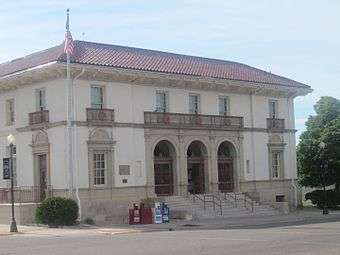 La Junta. Post Office.
 Fox Theatre in downtown.
 First Baptist Church.
 Downtown La Junta with the post office on back right.
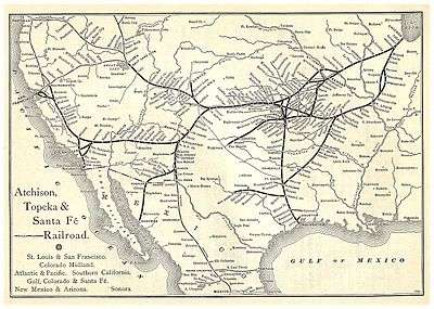 An Atchison, Topeka & Santa Fe Railway route map from 1891 issue of Grain Dealers and Shippers Gazetteer.
See also
- Outline of Colorado
- State of Colorado
- Arkansas River
- Bent's Old Fort National Historic Site
- Santa Fe National Historic Trail
References
- 1 2 "Active Colorado Municipalities". State of Colorado, Department of Local Affairs. Retrieved 2007-09-01.
- ↑ "Colorado Municipal Incorporations". State of Colorado, Department of Personnel & Administration, Colorado State Archives. 2004-12-01. Retrieved 2007-09-02.
- ↑ "US Board on Geographic Names". United States Geological Survey. 2007-10-25. Retrieved 2008-01-31.
- ↑ "ZIP Code Lookup" (JavaScript/HTML). United States Postal Service. Retrieved October 22, 2007.
- ↑ "Find a County". National Association of Counties. Retrieved 2011-06-07.
- ↑ Gannett, Henry (1905). The Origin of Certain Place Names in the United States. Government Printing Office. p. 179.
- ↑ Dawson, John Frank. Place names in Colorado: why 700 communities were so named, 150 of Spanish or Indian origin. Denver, CO: The J. Frank Dawson Publishing Co. p. 30.
- ↑ "Bomber Crash", Los Angeles Times, 28 September 1987
- ↑ "US Gazetteer files: 2010, 2000, and 1990". United States Census Bureau. 2011-02-12. Retrieved 2011-04-23.
- ↑ http://www.wunderground.com/history/airport/KLHX/2005/7/12/MonthlyCalendar.html?req_city=La%20Junta&req_state=CO&req_statename=&reqdb.zip=81050&reqdb.magic=1&reqdb.wmo=99999 Retrieved 12 June 2015.
- ↑ http://www.wunderground.com/history/airport/KLHX/1998/7/16/MonthlyCalendar.html?req_city=La%20Junta&req_state=CO&req_statename=&reqdb.zip=81050&reqdb.magic=1&reqdb.wmo=99999 Retrieved 16 June 2015.
- ↑ "NOWData - NOAA Online Weather Data". National Oceanic and Atmospheric Administration. Retrieved May 4, 2013.
- ↑ "Annual Estimates of the Resident Population for Incorporated Places: April 1, 2010 to July 1, 2015". Retrieved July 2, 2016.
- ↑ "Census of Population and Housing". Census.gov. Retrieved June 4, 2015.
- ↑ http://www.lajuntatribunedemocrat.com/article/20131106/NEWS/131109954/0/SEARCH
- ↑ BeeLine Express
- ↑ Greyhound Lines
- ↑ Oliver, Myrna (2003-05-29). "William Anderson, 83; WWII Pilot, Author of 'Bat*21'". Los Angeles Times. Retrieved 2016-06-24.
- ↑ "Ken Kesey". Biography.com. Retrieved 2016-06-24.
- ↑ "Tippy Martinez". Baseball-Reference.com. Retrieved 2016-06-24.
- ↑ "Wendell W. Fertig". Hall of Valor. Military Times. Retrieved 2016-06-24.
External links
| Wikimedia Commons has media related to La Junta, Colorado. |
- City website
- Economic Development Website
- La Junta Events Calendar
- La Junta Tourism Website
- CDOT map of the City of La Junta
- Bent's Old Fort National Historic Site
- Otero Junior College
- East Otero School District website
- La Junta Chamber of Commerce
Municipalities and communities of Otero County, Colorado, United States | ||
|---|---|---|
| Cities | 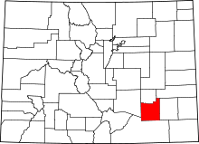 | |
| Towns | ||
| CDPs | ||
| Unincorporated communities | ||
| Ghost town | ||