La Houssaye-Béranger
| La Houssaye-Béranger | ||
|---|---|---|
| ||
 La Houssaye-Béranger | ||
|
Location within Normandy region  La Houssaye-Béranger | ||
| Coordinates: 49°37′54″N 1°05′11″E / 49.6317°N 1.0864°ECoordinates: 49°37′54″N 1°05′11″E / 49.6317°N 1.0864°E | ||
| Country | France | |
| Region | Normandy | |
| Department | Seine-Maritime | |
| Arrondissement | Rouen | |
| Canton | Clères | |
| Government | ||
| • Mayor (2008–2014) | Jean Vasseur | |
| Area1 | 8.06 km2 (3.11 sq mi) | |
| Population (2006)2 | 533 | |
| • Density | 66/km2 (170/sq mi) | |
| Time zone | CET (UTC+1) | |
| • Summer (DST) | CEST (UTC+2) | |
| INSEE/Postal code | 76369 / 76690 | |
| Elevation |
116–179 m (381–587 ft) (avg. 169 m or 554 ft) | |
|
1 French Land Register data, which excludes lakes, ponds, glaciers > 1 km² (0.386 sq mi or 247 acres) and river estuaries. 2 Population without double counting: residents of multiple communes (e.g., students and military personnel) only counted once. | ||
La Houssaye-Béranger is a commune in the Seine-Maritime department in the Haute-Normandie region in northern France.
Geography
A forestry and farming village situated in the Pays de Caux, some 16 miles (26 km) north of Rouen, at the junction of the D2, D90 and the D97 roads.
Heraldry
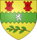 |
The arms of La Houssaye-Béranger are blazoned : Azure, a chevron argent between 2 anchors and a cow passant Or, a chief per pale 1 Gules, a mitre Or, and 2 paly Or and gules. |
Population
| Year | 1962 | 1968 | 1975 | 1982 | 1990 | 1999 | 2006 |
|---|---|---|---|---|---|---|---|
| Population | 252 | 264 | 260 | 360 | 427 | 498 | 533 |
| From the year 1962 on: No double counting—residents of multiple communes (e.g. students and military personnel) are counted only once. | |||||||
Places of interest
- The church of St. Pierre, dating from the twelfth century.
See also
References
External links
| Wikimedia Commons has media related to La Houssaye-Béranger. |
This article is issued from Wikipedia - version of the 7/13/2016. The text is available under the Creative Commons Attribution/Share Alike but additional terms may apply for the media files.