Barcelona Metro line 11
Barcelona Metro Line 11 | |||||||||||||||||||||||||||||||||||||||||||||||||
|---|---|---|---|---|---|---|---|---|---|---|---|---|---|---|---|---|---|---|---|---|---|---|---|---|---|---|---|---|---|---|---|---|---|---|---|---|---|---|---|---|---|---|---|---|---|---|---|---|---|
Legend
| |||||||||||||||||||||||||||||||||||||||||||||||||
Barcelona Metro line 11 is a full metro line with short trains in Barcelona, Catalonia, Spain.
![]() — Line 11, coloured light green and currently known as Trinitat Nova - Can Cuiàs, is a recently built line in the Barcelona Metro network, operated by TMB, and part of the ATM fare-integrated transport network in the city. It is unusual in being actually an underground light rail line instead of a conventional metro line. It only has 5 stations as of 2007 but is going to be extended into areas of the metropolitan area of Barcelona nowadays only served by Renfe and FGC.
— Line 11, coloured light green and currently known as Trinitat Nova - Can Cuiàs, is a recently built line in the Barcelona Metro network, operated by TMB, and part of the ATM fare-integrated transport network in the city. It is unusual in being actually an underground light rail line instead of a conventional metro line. It only has 5 stations as of 2007 but is going to be extended into areas of the metropolitan area of Barcelona nowadays only served by Renfe and FGC.
Overview
It is the latest addition to the main TMB network, having been opened in 2003. It serves the hilly and dense northern corner of Barcelona, from La Trinitat Nova - where it links with L4 - towards Can Cuiàs. It is currently undergoing construction so it is going to reach Universitat Autònoma de Barcelona and Ripollet. It's more accurately defined as a light rail-like addition to L4, still built under the standards of a regular metro line, as the addition of new stations was under consideration, and is already taking place. The colour assigned to this line by TMB is intended to represent a mixture of the official colours of L4 and L3, which join it at Trinitat Nova, its —at least temporarily— starting point. Additional metro lines projected to be built in following years will probably be quite similar to L11, and their colours have been designed using the same convention.
Chronology
- 2003 - Trinitat Nova-Can Cuiàs section opened.
Technical details
- Colour on map: Light green
- Number of stations: 5
- Type: automatic light rail
- Length: 2.1 km (1.3 mi)
- Rolling stock: 500 series
- Journey time: 4 minutes
- Track gauge: 1,435 mm (4 ft 8 1⁄2 in)
- Traction: Electricity
- Power supply: Rigid overhead wire
- Mobile phone coverage: All line
- Depots: Trinitat Nova
- Operator: TMB
Current stations

Rolling stock
The rolling stock on Line 11 is the 500 series. Its composition is unique in the network, as there are just three two-car trains running on this line.[1]
References
- ↑ "Dades bàsiques 2014" [Basic data 2014] (in Catalan and English). TMB. January 1, 2014. Archived from the original (pdf) on 2014-04-27. Retrieved 2014-08-23.
External links
Coordinates: 41°27′48″N 2°10′19″E / 41.4632°N 2.17181°E
| Route | 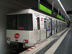 | |
|---|---|---|
| Rolling stock |
| |