Kreuzspitze (Ammergau Alps)
| Kreuzspitze | |
|---|---|
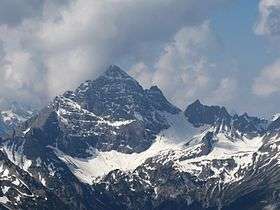 The Kreuzspitze from the Northeast | |
| Highest point | |
| Elevation | 2,185 m (7,169 ft) above sea level |
| Prominence | 1,182 m (3,878 ft) [1] |
| Isolation | 10.5 km |
| Coordinates | 47°31′35″N 10°55′07″E / 47.5263806°N 10.9184806°ECoordinates: 47°31′35″N 10°55′07″E / 47.5263806°N 10.9184806°E |
| Geography | |
| Parent range | Ammergau Alps |
| Geology | |
| Age of rock | Triassic |
| Mountain type | plattenkalk in the summit area, otherwise main dolomite[2] |
| Climbing | |
| Easiest route | State border – Hochgrießkar – Kreuzspitze |
The Kreuzspitze (2,185 m) is the highest mountain in the Bavarian section of the Ammergau Alps.
The mountain is located southeast of the Ammer Saddle. The easiest route to the summit is along the normal path from the north through the Hochgrieß Cirque (Hochgrießkar). A more scenic and varied route, however, is over the Kreuzspitzl to the south and then along the scenic ridge (UIAA climbing grade I to II) to the main peak. The mountain also offers a challenging ski tour through the Hochgrieß Cirque.[3]
The surrounding peaks of Frieder, Geierköpfe and Schellschlicht are also popular tour destinations.
References
- ↑ "Kreuzspitze - peakbagger". peakbagger.com. Retrieved 20 March 2015.
- ↑ Geologische Karte von Bayern mit Erläuterungen (1:500,000). Bayerisches Geologisches Landesamt, 1998.
- ↑ Routen description of the ski tour
Sources
- Dieter Seibert: AVF Allgäuer Alpen und Ammergauer Alpen, Rother Verlag Munich, 2004, ISBN 3-7633-1126-2
This article is issued from Wikipedia - version of the 12/21/2015. The text is available under the Creative Commons Attribution/Share Alike but additional terms may apply for the media files.