Kršan
| Kršan | ||
|---|---|---|
| Municipality | ||
| Kršan Municipality | ||
 | ||
| ||
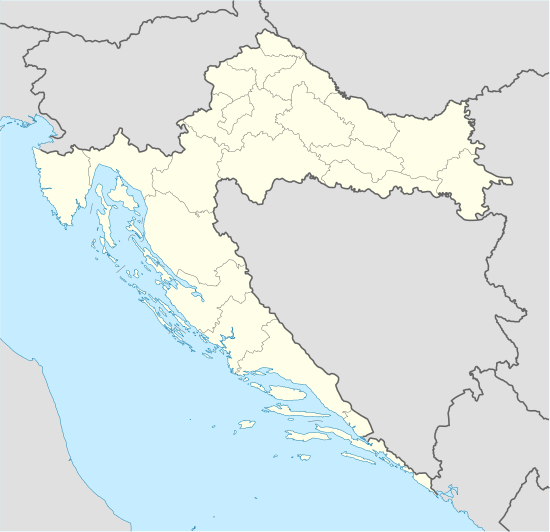 Kršan Location of Kršan in Croatia | ||
| Coordinates: 45°10′24″N 14°08′21″E / 45.17333°N 14.13917°ECoordinates: 45°10′24″N 14°08′21″E / 45.17333°N 14.13917°E | ||
| Country | Croatia | |
| County | Istria | |
| Area | ||
| • Total | 124 km2 (48 sq mi) | |
| Elevation | 130 m (430 ft) | |
| Population (2011)[1] | ||
| • Total | 2,951 | |
| • Density | 24/km2 (60/sq mi) | |
| Time zone | CET (UTC+1) | |
| • Summer (DST) | CEST (UTC+2) | |
| Postal code | 52233 | |
| Website |
www | |

Kršan (Italian: Chersano| Istro-Romanian: Cârșån) is a village and municipality in the eastern part of Istria County, Croatia.
Description
It is located in the eastern part of Istria, west of mountain Učka and south-west of Čepić field, on the state road D64 between county center Pazin (D48) and village Vozilići (D66). It is 12 km north of town Labin, and 22 km south-east of town Pazin.
The old town, medieval castle (mentioned 1274), lies on the hill, while new town and village is along the road. According to tradition, the name is derived from the rocky karst hill on which was built, Croatian: krš, German: karst, Italian: carso.
There are twenty three settlements in the municipality, and the census of 2011 had recorded:[1] Blaškovići (149), Boljevići (86), Čambarelići (154), Jesenovik (57), Kostrčani (30), Kožljak (160), Kršan (238), Lanišće (74), Lazarići (96), Letaj (43), Nova Vas (69), Plomin (113), Plomin Luka (173), Polje Čepić (148), Potpićan (518), Purgarija Čepić (228), Stepčići (40), Šušnjevica (69), Veljaki (120), Vozilići (236), Zagorje (116), Zankovci (8), Zatka Čepić (31).
Castle history

The castle is first mentioned in 1274 as Castrum Carsach, in peace agreement between Aquileia patriarch Raimondo della Torre, and count Albert I of Gorizia who in the conflict that started in 1268 during patriarch Gregorio di Montelongo conquered and destroyed fortified settlement. It was abandoned until the 13th or early 14th century, when it was rebuilt by Heinrich III. Until 1374, when counts of Gorizia became extinct, it was in duality of governance, between the real masters Counts of Gorizia, and Aquileia church in which name the Counts ruled over the castle. When the counts extinct it wasn't returned to Aquleia patriarchs (the state Patria del Friuli), but was inherited by Habsburg family.
The Habsburg family gave it to their vassal Krotendorfer or Cherstlein family, who after the castle had attribute "Karscheyner", and later also acquired Šumber castle. Since then the castle is mentioned as Kršan (Kerschan). They kept it until 1631, with short interruptions when its lords were families Devinski (1388–99), Walsee (1399-1431) and Wolf (1431–36). Later as lords are mentioned de Fini, Auersperg, Rampelli, Benvenuti dell Argenti, Josip de Sussani (who found the Istrian Demarcation from 13th-14th century), then his nephew Franjo Scribani, then nobleman from Plomin Matija Tonetti, and as last Giovanni Tonetti.
From the medieval castle is well preserved the tower of quadrangular layout, while residential and defensive complex was renovated in new residential buildings. The town is entered on the east side of the completely preserved city gate, on the right hand the city defense wall leans a number of houses of which the first is the old municipal house. In the inner courtyard of the castle has been preserved foursquare frame of Gothic portal from the 15th century, and well throat with engraved year 1666. The two-nave parish church of St. Antun was built in the 17th century, and the most of the church furniture dates from the 18th century. At the cemetery is nave chapel of St. Jakov from the 15th century. On the floor of the church, paved with brick and stone, are gravestones of feudal lords from the 15th, 16th and 17th century, particularly the plate from 1415 of Juraj Kršanski in a Latin epitaph inscribed with Gothic letters.
Demography
Municipality Kršan
| Population number according census[2] | |||||||||||||||
|---|---|---|---|---|---|---|---|---|---|---|---|---|---|---|---|
| 1857 | 1869 | 1880 | 1890 | 1900 | 1910 | 1921 | 1931 | 1948 | 1953 | 1961 | 1971 | 1981 | 1991 | 2001 | 2011 |
| 5,244 | 4,922 | 5,360 | 5,533 | 5,885 | 6,177 | 5,944 | 5,972 | 5,110 | 4,804 | 4,665 | 3,820 | 3,293 | 3,424 | 3,206 | 2,951 |
Note: Emerged from old Labin municipality. In 1857, 1869, 1921 and 1931 part of the data is contained in municipality Pićan, and in the same time Kršan contains data od Sveta Nedelja municipality.
Kršan (village)
| Population number according census[2] | |||||||||||||||
|---|---|---|---|---|---|---|---|---|---|---|---|---|---|---|---|
| 1857 | 1869 | 1880 | 1890 | 1900 | 1910 | 1921 | 1931 | 1948 | 1953 | 1961 | 1971 | 1981 | 1991 | 2001 | 2011 |
| 1,155 | 964 | 240 | 229 | 248 | 303 | 1,292 | 1,357 | 239 | 223 | 229 | 187 | 145 | 221 | 227 | 238 |
Note: In 1857, 1869, 1921 and 1931 contains data for villages Blaškovići, Boljevići, Čamberilići, Lazarići and Veljaki.
Gallery
- Castle
 Castle
 Alley
Alley
References
- 1 2 "Population by Age and Sex, by Settlements, 2011 Census: Kršan". Census of Population, Households and Dwellings 2011. Zagreb: Croatian Bureau of Statistics. December 2012.
- 1 2 "Naselja i stanovništvo Republike Hrvatske 1857.-2001." (in Croatian). Retrieved 23 December 2014.
- Bibliography
- Regan, Krešimir; Nadilo, Branko (May 2012). "Istarski Kašteli: Utvrde oko Čepićkog polja" [Istrian Castles: Forts around Čepić field] (PDF). Građevinar (in Croatian). Croatian Association of Civil Engineers. 64: 417–418. Retrieved 26 January 2015.
- Sirk, Željko (2002). "Između Lava i Orla (I): Srednjovjekovni gradovi, kašteli i kule Istre i Hrvatskog primorja i njihovi gospodari" [Between a Lion and an Eagle (I): Medieval towns, castles and towers of Istria and Croatian Littoral and their lords]. Nova Istra (in Croatian). Istrian branch of Croatian Association of Writers. Retrieved 31 January 2015.
- Milevoj, Marijan (2014). S ove strane Učke [On this side of Učka] (in Croatian). Labin: Mathias Flacius. ISBN 978-953-6875-54-2.
- Sources
External links
| Wikimedia Commons has media related to Kršan. |
Subdivisions of Istria County | ||
|---|---|---|
| Cities and towns |  | |
| Municipalities | ||