Koyna Dam
| Koyna Dam कोयना धरण | |
|---|---|
 | |
 Location of Koyna Dam in Maharashtra | |
| Official name | Koyna Dam D05104 |
| Location |
Koyna Nagar, Maharashtra India |
| Coordinates | 17°24′06″N 73°45′08″E / 17.40167°N 73.75222°ECoordinates: 17°24′06″N 73°45′08″E / 17.40167°N 73.75222°E |
| Construction began | 1956 |
| Opening date | 1964[1] |
| Owner(s) | Government of Maharashtra |
| Dam and spillways | |
| Type of dam | Rubble-concrete dam |
| Impounds | Koyna River |
| Height | 103.2 m (339 ft) |
| Length | 807.2 m (2,648 ft) |
| Reservoir | |
| Creates | Shivajisagar Lake |
| Total capacity | 2,797,400,000 m3 (2,267,900 acre·ft) |
| Surface area | 891.78 km2 (344 sq mi) |
| Power station | |
| Turbines |
Koyna dam foot powerhouse: 2 x 20 MW stage 1: 4 x 70 MW stage 2: 4 x 75 MW stage 3: 4 x 80 MW stage 4: 4 x 250 MW Total = 18 Francis turbines |
| Installed capacity | 1,960 MW |
| Official website | |
The Koyna Dam is one of the largest dams in Maharashtra, India. It is a rubble-concrete dam constructed on Koyna River which rises in Mahabaleshwar, a hillstation in Sahyadri ranges. It is located in Koyna Nagar, Satara district, nestled in the Western Ghats on the state highway between Chiplun and Karad.
The main purpose of dam is hydroelectricity with some irrigation in neighboring areas. Today the Koyna Hydroelectric Project is the largest completed hydroelectric power plant in India[2] having a total installed capacity of 1,920 MW. Due to its electricity generating potential Koyna river is considered as the 'life line of Maharashtra'.[3]
The spillway of the dam is located at the center. It has 6 radial gates. The dam plays a vital role of flood controlling in monsoon season.
The catchment area dams the Koyna river and forms the Shivasagar Lake which is approximately 50 km (31 mi) in length. It is one of the largest civil engineering projects commissioned after Indian independence. The Koyna hydro-electric project is run by the Maharashtra State Electricity Board.
The dam has withstood many earthquakes in the recent past, including the devastating 1967 Koynanagar earthquake, resulting in the dam developing some cracks. After the disaster grouting of the cracks was done. Also internal holes were drilled to relieve the hydrostatic pressures in the body of the dam. Indian scientific establishment has formulated an ambitious project to drill a deep borehole in the region and intensely study the earthquake activity. This would help in better understanding and possible forecast of earthquakes. The proposal is to drill up to 7 km and study the physical, geological and chemical processes and properties of the reservoir triggered earthquake zone in real time. It would be an international project to be led by Indian scientists.[4]
In 1973 the non-overflow portion of the dam was strengthened, followed by strengthening the spillway section in 2006. Now the dam is expected to be safe against any future earthquake, including ones with a higher intensity than that of 1967.
 The Koyna Dam in Maharashtra |
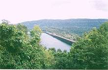
 The Shivajisagar Lake. |
See also
- Koyna Hydroelectric Project
- Koyna Wildlife Sanctuary
- List of power stations in India
- List of conventional hydroelectric power stations
References
- ↑ "Koyna D05104". Retrieved March 1, 2013.
- ↑ "Electricity in India - Sources, Generation, Usage of Power in india". india-reports.com.
- ↑ "Koyna Sanctuary Plundered". downtoearth.org.in. January 31, 2011. Retrieved November 14, 2011.
- ↑ "Major project to study earthquake activity at Koyna". thehindubusinessline.com.
External links
Satara district topics | ||
|---|---|---|
| History |
|  |
| Battles | ||
| Rivers | ||
| Dams | ||
| Lakes |
| |
| Ghats | ||
| Caves | ||
| Cities and towns | ||
| Villages | ||
| Places to see |
| |
| Monuments | ||
| Transport | ||
| Education | ||
| Lok Sabha constituencies | ||
| Vidhan Sabha constituencies | ||
| Stadiums and Sports venues |
| |
| Culture | ||