Kouvaras
| Kouvaras Κουβαράς | |
|---|---|
 Kouvaras | |
|
Location within the regional unit  | |
| Coordinates: 37°50′N 23°58′E / 37.833°N 23.967°ECoordinates: 37°50′N 23°58′E / 37.833°N 23.967°E | |
| Country | Greece |
| Administrative region | Attica |
| Regional unit | East Attica |
| Municipality | Saronikos |
| • Municipal unit | 24.371 km2 (9.410 sq mi) |
| Elevation | 209 m (686 ft) |
| Population (2011)[1] | |
| • Municipal unit | 2,008 |
| • Municipal unit density | 82/km2 (210/sq mi) |
| Time zone | EET (UTC+2) |
| • Summer (DST) | EEST (UTC+3) |
| Postal code | 190 03 |
| Area code(s) | 22910 |
| Vehicle registration | Z |
| Website | www.koinotita-kouvara.gr |
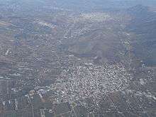
Aerial view of Kalivia Thorikou, Kouvaras and Keratea as seen from the northwest
Kouvaras (Greek: Κουβαράς) is a village and a former community in East Attica, Greece. Since the 2011 local government reform it is part of the municipality Saronikos, of which it is a municipal unit.[2] The municipal unit has an area of 24.371 km2.[3]
Geography
Kouvaras is situated in the southeastern part of the Attica peninsula. There are several low mountains around Kouvaras, including Panion to its southwest and Merenta to its north. It is 2 km north of Keratea, 4 km southeast of Kalyvia Thorikou and 27 km southeast of Athens city centre. The Greek National Road 89 (Gerakas - Koropi - Lavrio - Sounio) passes southwest of the town. The municipal unit Kouvaras also includes the village Neos Kouvaras (pop. 566), 1 km to the southwest.
Historical population
| Year | Village population | Municipal unit population |
|---|---|---|
| 1981 | 1,194 | - |
| 1991 | 928 | 1,369 |
| 2001 | 1,091 | 1,542 |
| 2011 | 1,426 | 2,008 |
References
- ↑ "Απογραφή Πληθυσμού - Κατοικιών 2011. ΜΟΝΙΜΟΣ Πληθυσμός" (in Greek). Hellenic Statistical Authority.
- ↑ Kallikratis law Greece Ministry of Interior (Greek)
- ↑ "Population & housing census 2001 (incl. area and average elevation)" (PDF) (in Greek). National Statistical Service of Greece.
External links
 |
Markopoulo Mesogeias | | ||
| Kalyvia Thorikou | |
|||
| ||||
| | ||||
| Keratea | Keratea |
This article is issued from Wikipedia - version of the 11/28/2016. The text is available under the Creative Commons Attribution/Share Alike but additional terms may apply for the media files.