Kinniside Stone Circle
 Kinniside Stone Circle | |
 Shown within Cumbria | |
| Location | Cumbria |
|---|---|
| Coordinates | 54°30′47″N 3°27′10″W / 54.513013°N 3.452687°W |
| Type | Stone circle |
| History | |
| Periods | Neolithic? / Bronze Age? |
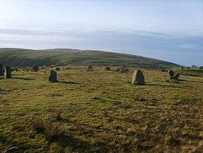
Kinniside Stone Circle (or Blakeley Raise Stone Circle) is a reconstructed stone circle in the civil parish of Ennerdale and Kinniside in Cumbria, England (grid reference NY060140).
Description
Kinniside Stone Circle is situated next to the fell road from Ennerdale Bridge to Calder Bridge in Cumbria.[1] It consists of 11 small stones of local granite with a possible cairn at its centre.[2]
The circle was apparently dismantled in the 18th century by a farmer who used the stones for gate-posts.[2] In 1925 a Doctor Quine of Frizington "restored" the stone circle, setting the stones in concrete.[2] Whether or not he erected the stones in their original stone holes is unclear, and it is unlikely that all of the re-erected stones come from the original circle.[2]
References
- ↑ "Kinniside Stone Circle". Visit Cumbria. Retrieved 17 August 2015.
- 1 2 3 4 Historic England. "Monument No. 8812". PastScape. Retrieved 17 August 2015.
External links
![]() Media related to Kinniside Stone Circle at Wikimedia Commons
Media related to Kinniside Stone Circle at Wikimedia Commons