Kingston and Arthurs Vale Historic Area
| Kingston and Arthurs Vale Historic Area | |
|---|---|
|
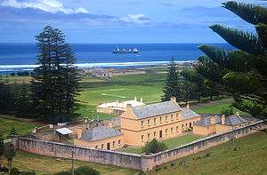
Military Barracks and Officer Quarters (1829-34), Quality Row Military Precinct, within Kingston and Arthurs Vale Historic Area. | |
| Type | Historic Area |
| Location | Quality Row, Kingston, southern side of Norfolk Island |
| Coordinates | 29°03′12″S 167°57′31″E / 29.05333°S 167.95861°ECoordinates: 29°03′12″S 167°57′31″E / 29.05333°S 167.95861°E[1] |
| Area | 255 hectares[1] |
| Status |
Australian National Heritage List World Heritage list |
| Website | http://www.kavha.gov.nf/# |
| Type | Cultural |
| Criteria | iv, vi |
| Designated | 2010 (34th session) |
| Part of | Australian Convict Sites |
| Reference no. | 1306 |
| State Party |
|
| Region | Asia-Pacific |
Kingston and Arthurs Vale Historic Area is an old settlement on the Kingston coastal plains (bounded by hills), southern side of Norfolk Island, consisting of a large group of buildings from the British Empire's convict era (1788–1855), now considered to be of such cultural significance to Australia and to the World that the area has been formally inscribed onto both the Australian National Heritage List[2] and UNESCO's World Heritage list[3] as amongst:
" .. the best surviving examples of large-scale convict transportation and the colonial expansion of European powers through the presence and labour of convicts."[4]
See also
- Australian Convict Sites
- Norfolk Island first penal settlement
- Norfolk Island second penal settlement
External links
- "Kingston and Arthurs Vale Historic Area (Place ID 105962)". Australian Heritage Database. Department of the Environment.
References
- 1 2 Chapter 1 of Australian Government's "Australian Convict Sites" World Heritage nomination Accessed 5 August 2010
- ↑ Australian Department of Environment, Water, Heritage and the Arts "National Heritage: Kingston and Arthurs Vale Historic Area (KAVHA), Norfolk Island" webpage Accessed 4 August 2010
- ↑ Australia's Department of Environment, Heritage, Water and the Arts "World Heritage: Australian Convict Sites" webpage Accessed 2 August 2010
- ↑ UNESCO's World Heritage "Australian Convict Sites" webpages Accessed 2 August 2010
This article is issued from Wikipedia - version of the 6/12/2016. The text is available under the Creative Commons Attribution/Share Alike but additional terms may apply for the media files.