King Leopold Ranges
The King Leopold Ranges are a range of hills in the western Kimberley region of Western Australia. The range was named on 6 June 1879 by the explorer Alexander Forrest, during an expedition in the Kimberley area, after King Leopold II of Belgium, "for the great interest taken by His Majesty in exploration".[1]
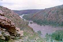
Crossed by the Gibb River Road about 134 kilometres (83 mi) east of Derby, part of the ranges are covered by the 3,921 square kilometres (1,514 sq mi) King Leopold Ranges Conservation Park, managed by the Department of Parks and Wildlife. The ranges separate the main Kimberley plateau from the southern Fitzroy plains and consist of quartz sandstone intruded by dolerite.
The ranges are shaped like a crescent with a length of 567 kilometres (352 mi) running from the northern end of the Durack Range in the East to east of Secure Bay in the West Kimberley. The range is estimated to cover a total area of 30,794 square kilometres (11,890 sq mi).[2]
The ranges, which have an average height 600 metres (1,969 ft), were named by Alexander Forrest in 1879 after King Leopold II of Belgium. The highest point of the range is found at Mount Wells which is 983 metres (3,225 ft) above mean sea level.[3] The next two highest peaks are Mount Ord at 936 metres (3,071 ft) and Mount Broome at 927 metres (3,041 ft).
Nearby features include Mount Hart, Bell Gorge, Silent Grove and Lennard Gorge as well as the Napier Range and Queen Victoria's Head granite outcrop. Fitzroy Bluff is formed where the Fitzroy River carves through the range. Camping is permitted at Mount Hart Station, Bell Creek or at Silent Grove.
The traditional owners of the area are the Ngarinjin, Konejandi and Bunaba peoples.[4]
Cattle were first overlanded across the range in 1903. Leaving from Fitzroy Crossing and used to stock Mount Barnett Station, the trip took over six weeks to complete.[5]
Physiography
The ranges are a distinct physiographic section of the larger Kimberly Block province, which in turn is part of the larger West Australian Shield division.
Ranges
The King Leopold Range is made up of many smaller ranges including; Lady Forrest Range,[6] Isdell Range,[7][8] Narrie Range,[9] Sir John Range,[10] Precipice Range [11] and Durack Range.[12][13]
References
- ↑ Forrest, Alexander (8 Feb 1880). "From the De Grey to Port Darwin: Journal of Exploration". The West Australian. p. 1S. Retrieved 19 Aug 2013.
- ↑ "Bonzle Digital Atlas - Map of King Leopold Ranges". 2009. Retrieved 2009-03-11.
- ↑ "Landgate Media Release - Proposal to rename King Leopold Ranges" (PDF). 2008. Retrieved 2009-03-12.
- ↑ "AusAnthrop Australian Aboriginal tribal database". 2005. Retrieved 2009-03-11.
- ↑ "Veteran Is Survivor of Historic Overland Drive.". The Daily News. Perth, Western Australia: National Library of Australia. 8 February 1949. p. 7. Retrieved 29 November 2014.
- ↑ From Geosciences Australia - Latitude: 17°25'34"S [Decimal Degrees -17.42611°] Longitude: 125°52'49.1"E [Decimal Degrees 125.8803°]
- ↑ Australia. Division of National Mapping (1973), Isdell (Edition 1 ed.), Canberra Division of National Mapping, retrieved 15 March 2015
- ↑ Latitude: 17°03'13"S [Decimal Degrees -17.05361°]Longitude: 125°21'29.2"E [Decimal Degrees 125.3581°]
- ↑ Latitude: 17°30'35"S [Decimal Degrees -17.50972°] Longitude: 126°25'19.9"E [Decimal Degrees 126.4222°]
- ↑ Latitude: 17°35'22"S [Decimal Degrees -17.58944°] Longitude: 126°10'59.2"E [Decimal Degrees 126.1831°]
- ↑ Latitude: 17°16'02"S [Decimal Degrees -17.26722°] Longitude: 125°36'19.1"E [Decimal Degrees 125.6053°]
- ↑ Mountford, Charles P. (Charles Pearcy) (1954), A carved human figure from the Durack Ranges, Northwestern Australia, retrieved 15 March 2015
- ↑ Latitude: 16°47'31"S [Decimal Degrees -16.79194°] Longitude: 127°41'44.2"E [Decimal Degrees 127.6956°]
Coordinates: 17°30′S 125°45′E / 17.500°S 125.750°E