Kilmacthomas
| Kilmacthomas Coill Mhic Thomáisín | |
|---|---|
| Town | |
 Kilmacthomas Location in Ireland | |
| Coordinates: 52°12′25″N 7°25′21″W / 52.206816°N 7.422491°WCoordinates: 52°12′25″N 7°25′21″W / 52.206816°N 7.422491°W | |
| Country |
|
| Province | Munster |
| County | County Waterford |
| Elevation | 50 m (160 ft) |
| Time zone | WET (UTC+0) |
| • Summer (DST) | IST (WEST) (UTC-1) |
| Irish Grid Reference | S392060 |
Kilmacthomas or Kilmactomas (Irish: Coill Mhic Thomáisín),[1] often referred to locally as "Kilmac", is a town on the River Mahon in County Waterford, Ireland. It lies on the R677 immediately north of the N25 national primary road from Dungarvan to Waterford.
The town has a population of some 1768 people. The chief tourist attraction of the locality are the Mahon Falls.
%2C_Railway_viaduct_-_geograph.org.uk_-_261327.jpg)
History
During the Cromwellian conquest of Ireland, in December, 1649, Oliver Cromwell, marched from Waterford to Kilmacthomas during the Siege of Waterford. The weather was wet and stormy and the river was in flood, so the army couldn't cross. Two nights were spent in the field that is now the public park. Cromwell was said to have described Waterford county on his march from Waterford to Kilmacthomas in the winter of 1649 as being a craggy and desolate place.
Daniel O'Connell passed through Kilmac' on a campaign trail and he wrote:[2]
- We breakfasted at Kilmacthomas, a town belonging to the Beresfords but the people belong to us. They came out to meet us with green boughs and such shouting you can have no idea of. I harangued them from the window of the inn, and we had a good deal of laughing at the bloody Beresfords. Judge what the popular feeling must be when in this, a Beresford town, every man their tenant, we had such a reception.
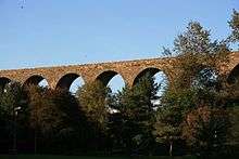
In the early 1870s the influence of the industrial revolution reached Kilmacthomas when the Waterford to Mallow railroad came to town. There is an example of a stone viaduct in the town spanning the Mahon River.Although the last passenger services ceased in the late 1960s the railway continued to operate with the haulage of oil and magnesite for another couple of decades. This railway is now disused. The viaduct at Kilmacthomas has been preserved.
Geography
The village is situated on the River Mahon, the eastbank is known as Kilmacthomas and the westbank as Gruaigeshuneen. The postal area of Kilmacthomas can include Newtown, Ballylaneen, Lemybrien, Kill, Mahon Bridge, The Nire, and Kilrossanty. The N25 bridge over the River Mahon is named after local sporting hero Percy Kirwan.
The Mahon River has a stock of wild brown trout. The salmon run mostly in the autumn and winter, but start running from the end of June. Salmon trout (know locally as "Pale") are also found in the river. Sea trout run in late July and August. There has been a collapse in fish stocks in the 1980s and 1990s but stocks are on the rise once more since a moratorium on netting has been emplaced.
Geologically Kilmacthomas gives its name to the "Kilmacthomas Formation", which is composed of Palaeozoic deep marine metasediments and metavolcanics. Evidence of manganese nodules have been noted in the new bypass cutting recently constructed near the village.
Kilmac' is located halfway between Waterford City and the county capital; Dungarvan. West of the village are the foothills of the Comeragh mountains, while five miles to the south is the 'Copper Coast' with the beach of Bonmahon / Bunmahon(Bún Machan).
Economy
- The Flahavan's cereal factory began milling Irish oats in about 1785. Nowadays it makes oatmeal and other cereal products.
- Alaska Fireplaces make fireplaces at a cold spot in Kilmacthomas (hence the name due to being exposed to the Cuteen wind) which are sold nationwide. Now located in the former Work House, which has been converted into Kilmacthomas Business Centre.
- Kilmacthomas acts as a dormitory town for Waterford and Dungarvan.
Education
There are 4 schools in Kilmacthomas. St Declan's Community College is the largest second level school in the county area, with in excess of 500 pupils. The (Kilmac') Convent Primary school caters for the younger children,newtown which is a mile away and has 100 students, while the pre-school boys and girls attend the Naíonra on the High Road. There are 16 different schools within 15 km of Kilmacthomas.
Bars
Pubs in the town include: Powers, Dannys (Kirwans), Kielys, Keatings/Lynns (Main Street), Philomena Flynns (Newtown), Morrisseys (the Square), Lenihans (Newtown), Harleys Bar (River Street), and Kierseys Bar & Restaurant (Main Street).
Sports clubs
Gaelic Athletic Association Clubs:
- John Mitchels, Kilnagrange, Kilmacthomas, Co. Waterford
- Kilmacthomas GAA Club, Union Road, Kilmacthomas, Co. Waterford
- Kilmacthomas Juvenile GAA Club, Union Road, Kilmacthomas, Co. Waterford
- Saint Mary's Juvenile GAA Club, Dunphy's Pub, Newtown, Kilmacthomas, Co. Waterford
- The Arches Darts Team, The Arches Bar, Kilmacthomas - currently led by Denis "the Menace" Flynn, the king of double 1.
People
- Birthplace of Tyrone Power (1795-1841), actor, comedian, author and theatrical manager.
- Lord of the Dance and Feet of Flames original lead Gillian Norris currently lives and works in Kilmacthomas, where she runs her own beauty salon and spa.
See also
References
- ↑ "Placenames Database of Ireland". Dublin City University. Retrieved 5 January 2015.
- ↑ Source. Letter from Daniel O’Connell to his wife about campaigning in Co Waterford, 19 June 1826, Irish Monthly 12 (1884) 216.
Places in County Waterford | ||
|---|---|---|
| Towns |  | |
| Villages and Townlands |
| |
| ||