Killingly, Connecticut
| Killingly, Connecticut | ||
|---|---|---|
| Town | ||
|
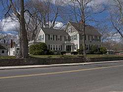
A house on Broad Street | ||
| ||
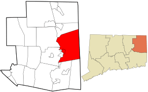 Location in Windham County and the state of Connecticut. | ||
| Coordinates: 41°49′53″N 71°51′01″W / 41.83139°N 71.85028°WCoordinates: 41°49′53″N 71°51′01″W / 41.83139°N 71.85028°W | ||
| Country |
| |
| State |
| |
| County | Windham | |
| NECTA | Danielson | |
| Region | Northeastern Connecticut | |
| Incorporated | 1708 | |
| Government | ||
| • Type | Council-manager | |
| • Town manager | Sean Hendricks | |
| • Council chairman | David Griffiths (D) | |
| Area | ||
| • Total | 50.0 sq mi (129.5 km2) | |
| • Land | 48.5 sq mi (125.7 km2) | |
| • Water | 1.5 sq mi (3.8 km2) | |
| Elevation | 449 ft (137 m) | |
| Population (2005)[1] | ||
| • Total | 17,386 | |
| • Density | 358/sq mi (138/km2) | |
| Time zone | Eastern (UTC-5) | |
| • Summer (DST) | Eastern (UTC-4) | |
| ZIP code | 06239, 06241, 06243 | |
| Area code(s) | 860 | |
| FIPS code | 09-40500 | |
| GNIS feature ID | 0213447 | |
| Website |
www | |

Killingly is a town in Windham County, Connecticut, United States. The population was 17,370 at the 2010 census. It consists of the borough of Danielson and the villages of Attawaugan, Ballouville, Dayville, East Killingly, Rogers, and South Killingly.
Geography
According to the United States Census Bureau, the town has a total area of 50.0 square miles (129 km2), of which, 48.5 square miles (126 km2) of it is land and 1.5 square miles (3.9 km2) of it (2.94%) is water.
Principal communities
- Attawaugan
- Ballouville
- Chestnut Hill
- Danielson (borough)
- Dayville
- East Killingly
- Elmville
- Killingly Center
- Rogers
- South Killingly
On the National Register of Historic Places
- Broad Street – Davis Park Historic District — Roughly along Broad Street, from Dorrance Street to Winter Street (added 1998)
- Daniel's Village Archeological Site (added 1978)
- Danielson Main Street Historic District — Main Street from Water Street to Spring Street (added 1992). The area features Colonial Revival, Italianate, and other architectural styles.
- Dayville Historic District — Main and Pleasant Streets (added 1988)
- Elliottville Lower Mill — Peep Toad Road (added 1982)
- Old Killingly High School — 185 Broad Street (added 1992)
- Temple Beth Israel (Danielson, Connecticut) — 39 Killingly Drive (added 2003)
Demographics
| Historical population | |||
|---|---|---|---|
| Census | Pop. | %± | |
| 1820 | 2,803 | — | |
| 1840 | 3,685 | — | |
| 1850 | 4,543 | 23.3% | |
| 1860 | 4,926 | 8.4% | |
| 1870 | 5,712 | 16.0% | |
| 1880 | 6,921 | 21.2% | |
| 1890 | 7,027 | 1.5% | |
| 1900 | 6,835 | −2.7% | |
| 1910 | 6,564 | −4.0% | |
| 1920 | 8,178 | 24.6% | |
| 1930 | 8,852 | 8.2% | |
| 1940 | 9,547 | 7.9% | |
| 1950 | 10,015 | 4.9% | |
| 1960 | 11,298 | 12.8% | |
| 1970 | 13,573 | 20.1% | |
| 1980 | 14,519 | 7.0% | |
| 1990 | 15,889 | 9.4% | |
| 2000 | 16,472 | 3.7% | |
| 2010 | 17,370 | 5.5% | |
| Est. 2014 | 17,172 | [2] | −1.1% |
As of the census[4] of 2010, there were 17,370 people, 6,749 households, and 4,528 families residing in the town. The population density was 358.1 people per square mile (137.9/km²). There were 7,592 housing units at an average density of 156.5 per square mile (60.3/km²). The racial makeup of the town was 93.1% White, 1.5% African American, 0.4% Native American, 1.8% Asian, 0.7% from other races, and 2.4% from two or more races. Hispanic or Latino of any race were 3.0% of the population.
The borough of Danielson, as well as the town of Killingly, is also home to a small but significant Laotian community. Both Danielson and Killingly are on the nation's list of top 50 cities with the highest percentage of citizens claiming Laotian ancestry.
Of the 6,749 households: 29.2% had children under the age of 18 living with them, 47.8% were married couples living together, 13.2% had a female householder with no husband present, and 32.9% were non-families. 25.1% of all households were made up of individuals and 9.9% had someone living alone who was 65 years of age or older. The average household size was 2.52 and the average family size was 2.98.
In the town the population was spread out with 22.4% under the age of 18, 8.2% from 18 to 24, 27.0% from 25 to 44, 28.5% from 45 to 64, and 13.9% who were 65 years of age or older. The median age was 40 years. For every 100 females there were 97.4 males. For every 100 females age 18 and over, there were 94.7 males.
The median income for a household in the town was $55,598, and the median income for a family was $68,565. Males had a median income of $49,467 versus $35,429 for females. The per capita income for the town was $26,585. About 8.5% of families and 10.3% of the population were below the poverty line, including 12.7% of those under age 18 and 6.1% of those age 65 or over.
| Voter registration and party enrolment as of October 25, 2005[5] | |||||
|---|---|---|---|---|---|
| Party | Active voters | Inactive voters | Total voters | Percentage | |
| Democratic | 2,335 | 110 | 2,445 | 26.40% | |
| Republican | 1,543 | 69 | 1,612 | 17.41% | |
| Unaffiliated | 4,935 | 260 | 5,195 | 56.10% | |
| Minor parties | 8 | 0 | 8 | 0.09% | |
| Total | 8,821 | 439 | 9,260 | 100% | |
Transportation
Danielson Airport is a state owned, public use airport located two nautical miles (4 km) northwest of the central business district of Danielson, a borough in Killingly.[6]
Notable people
- Mary Dixon Kies (1752–1837), the first woman in the United States to receive a patent (in 1809, for a method of weaving straw with silk or thread). Kies was born and lived in South Killingly, an unincorporated village in the Town of Killingly.
- Francis Alexander, (1800–1881), born in Killingly, was a portrait painter[7]
- William Torrey Harris (1835–1909), a philosopher who introduced reindeer to Alaska, educator (and later U.S. Commissioner of Education) who introduced the first permanent kindergarten, and lexicographer who introduced the "divided page" into dictionaries (the 1909 edition of Webster's New International Dictionary). He was born in North Killingly. He also founded the first philosophical journal in the country.
- Sidney P. Marland, Jr. (1914–1992), U.S. Commissioner of Education from 1970 to 1972 and then the first Assistant Secretary of Education in the Department of Health, Education, and Welfare from 1972 to 1973, under President Nixon. Marland was born in Danielson, a borough of the Town of Killingly. Killingly may be the only town in the nation to be the birthplace of two U.S. Commissioners of Education.
- Charles Tiffany (1812–1902) born in town, owner of Tiffany and Company (and father of the more famous Louis Comfort Tiffany, a designer)
- Ebenezer Young (1783–1851) was a United States Representative from Connecticut.
References
- ↑ U.S. Census Bureau Population Estimates
- ↑ "Annual Estimates of the Resident Population for Incorporated Places: April 1, 2010 to July 1, 2014". Retrieved June 4, 2015.
- ↑ "Census of Population and Housing". Census.gov. Retrieved June 4, 2015.
- ↑ "American FactFinder". United States Census Bureau. Retrieved 2008-01-31.
- ↑ "Registration and Party Enrolment Statistics as of October 25, 2005" (PDF). Connecticut Secretary of State. Archived from the original (PDF) on September 23, 2006. Retrieved 2006-10-02.
- ↑ FAA Airport Master Record for LZD (Form 5010 PDF). Federal Aviation Administration. Effective May 31, 2012.
- ↑ Who Was Who in America, Historical Volume, 1607-1896. Marquis Who's Who. 1967.
External links
- Town government Web site
- Mystic Country: The Eastern Regional Tourism District
- Historic American Engineering Record (HAER) No. CT-145, "Dayville Mills Hydroelectric Facility, Killingly Center, Windham County, CT", 2 photos, 12 data pages, 3 photo caption pages
- HAER No. CT-145-A, "Dayville Mills Hydroelectric Facility, Dam", 3 photos, 8 data pages, 3 photo caption pages
- HAER No. CT-145-B, "Dayville Mills Hydroelectric Facility, Powerhouse", 9 photos, 8 data pages, 4 photo caption pages

Municipalities and communities of Windham County, Connecticut, United States | ||
|---|---|---|
| Towns | 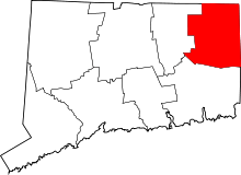 | |
| Borough | ||
| Other communities | ||