Keystone, Colorado
| Keystone, Colorado | |
|---|---|
| CDP | |
 Location in Summit County and the state of Colorado | |
| Coordinates: 39°36′15″N 105°56′53″W / 39.60417°N 105.94806°WCoordinates: 39°36′15″N 105°56′53″W / 39.60417°N 105.94806°W | |
| Country |
|
| State |
|
| County | Summit |
| Area | |
| • Total | 40.6 sq mi (105.2 km2) |
| • Land | 40.6 sq mi (105.2 km2) |
| • Water | 0 sq mi (0 km2) |
| Elevation[1] | 9,173 ft (2,796 m) |
| Population (2010) | |
| • Total | 1,079 |
| • Density | 26.6/sq mi (10.2/km2) |
| Time zone | Mountain (MST) (UTC-7) |
| • Summer (DST) | MDT (UTC-6) |
| ZIP code[2] | 80435 |
| Area code(s) | 970 |
| FIPS code | 08-40550 |
| GNIS feature ID | 0182373 |
| Website | keystonecolorado.com |
Keystone is a census-designated place (CDP) in Summit County, Colorado, United States. The population was 1,079 at the 2010 census.[3] The Dillon Post Office (ZIP Code 80435) serves Keystone postal addresses.[2]
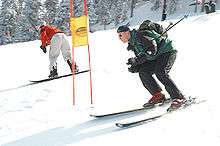
Keystone is the home of the Keystone Resort. Originally constructed in the 1970s by the Ralston Purina Company, it is now owned by Vail Resorts. The Keystone Resort ski area occupies 3 separate mountains: Dercum Mountain, North Peak, and The Outback. Recent expansion of terrain and services offers snowcat skiing in Independence Bowl, Bergman Bowl, Erickson Bowl, in addition to the existing North Bowl and South Bowl on Wapiti Peak. The resort has many summer and winter outdoor activities. The winter activities include alpine skiing, snowboarding, tubing, ice-skating, cross-country skiing, horse-drawn sleigh ride dinners, and snowmobiling. The summer activities include hiking, mountain biking, fishing, trail running, golf on two championship courses, and paddle boating on Keystone Lake.
The Keystone ski area has:
- 2,870 acres (11.6 km2)
- 3,128 feet (953 m) vertical
- Base elevation: 9,280 feet (2,830 m)
- Summit elevation: 12,408 feet (3,782 m)
- 131 trails
- Degree of difficulty percentages for trails: Easiest-14 percent, More Difficult-29 percent, Most Difficult-57 percent
- 20 Lifts including 2 gondolas, 1 express six-pack and 5 high speed quads.
- The only Night skiing in the area.
Keystone is only a short drive from other resorts in Summit County - about 10 minutes to Arapaho Basin, 20 minutes to Breckenridge, and 20 minutes to Copper Mountain. Day lift tickets and season passes at Keystone are also honored at Breckenridge and Arapaho Basin.
Geography
Keystone is located at 39°36′15″N 105°56′53″W / 39.604233°N 105.948111°W.[4]
According to the United States Census Bureau, the CDP has a total area of 40.6 square miles (105 km2), of which, 40.6 square miles (105 km2) of it is land and 0.02% is water.
Demographics
As of the census[3] of 2000, there were 825 people, 327 households, and 88 families residing in the CDP. The population density was 20.3 people per square mile (7.8/km²). There were 2,606 housing units at an average density of 64.1 per square mile (24.8/km²). The racial makeup of the CDP was 86.55% White, 0.48% African American, 1.33% Asian, 9.09% from other races, and 2.55% from two or more races. Hispanic or Latino of any race were 13.58% of the population.
There were 327 households out of which 6.7% had children under the age of 18 living with them, 22.0% were married couples living together, 1.5% had a female householder with no husband present, and 72.8% were non-families. 21.1% of all households were made up of individuals and 0.6% had someone living alone who was 65 years of age or older. The average household size was 2.23 and the average family size was 2.42.
In the CDP the population was spread out with 7.2% under the age of 18, 39.9% from 18 to 24, 36.5% from 25 to 44, 12.5% from 45 to 64, and 4.0% who were 65 years of age or older. The median age was 26 years. For every 100 females there were 186.5 males. For every 100 females age 18 and over, there were 195.8 males.
The median income for a household in the CDP was $43,654, and the median income for a family was $68,750. Males had a median income of $26,563 versus $30,833 for females. The per capita income for the CDP was $24,085. None of the families and 22.1% of the population were living below the poverty line, including no under eighteens and none of those over 64.
See also
References
- ↑ "US Board on Geographic Names". United States Geological Survey. 2007-10-25. Retrieved 2008-01-31.
- 1 2 "ZIP Code Lookup" (JavaScript/HTML). United States Postal Service. December 14, 2006. Retrieved December 14, 2006.
- 1 2 "American FactFinder". United States Census Bureau. Retrieved 2008-01-31.
- ↑ "US Gazetteer files: 2010, 2000, and 1990". United States Census Bureau. 2011-02-12. Retrieved 2011-04-23.
External links
| Wikivoyage has a travel guide for Keystone (Colorado). |
Municipalities and communities of Summit County, Colorado, United States | ||
|---|---|---|
| Towns |  | |
| CDPs | ||
| Ghost towns | ||