Noble County, Indiana
| Noble County, Indiana | |
|---|---|
| County | |
| Noble County | |
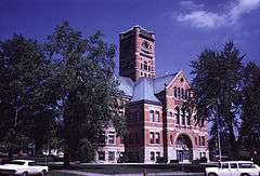 Noble County Courthouse in Abion, Indiana | |
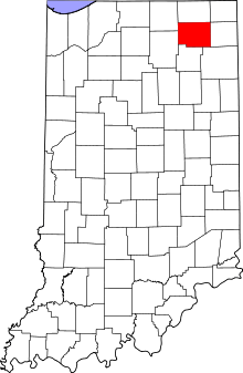 Location in the U.S. state of Indiana | |
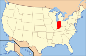 Indiana's location in the U.S. | |
| Founded | 1836 |
| Named for | Governor Noah Noble |
| Seat | Albion |
| Largest city | Kendallville |
| Area | |
| • Total | 417.43 sq mi (1,081 km2) |
| • Land | 410.84 sq mi (1,064 km2) |
| • Water | 6.59 sq mi (17 km2), 1.58% |
| Population | |
| • (2010) | 47,536 |
| • Density | 116/sq mi (44.64/km²) |
| Congressional district | 3rd |
| Time zone | Eastern: UTC-5/-4 |
| Website |
nobleco |
| Footnotes: Indiana county number 57 | |
Noble County is a county located in the U.S. state of Indiana. As of 2010, the population was 47,536.[1] The county seat is Albion.[2] The county is divided into 13 townships which provide local services.[3][4]
Noble County comprises the Kendallville, IN Micropolitan Statistical Area and is included in the Fort Wayne-Huntington-Auburn, IN Combined Statistical Area.
History
Noble County was formed in 1836. It was named for Governor Noah Noble.[5] The original settlers in Noble County were settlers from New England known as "Yankee's", these were people descended from the English Puritans who settled New England in the 1600s. They were part of a wave of New Englanders who migrated west to what was then the Northwest Territory during the early 1800s. This migration was sparked as a result of the completion of the Erie Canal and conclusion of the Black Hawk War. They founded the towns of Kendallville and Albion.[6]
Geography
According to the 2010 census, the county has a total area of 417.43 square miles (1,081.1 km2), of which 410.84 square miles (1,064.1 km2) (or 98.42%) is land and 6.59 square miles (17.1 km2) (or 1.58%) is water.[7] Sand Hill (1073 feet/327 metres), the second-highest named point in Indiana, is located in Noble County.[8]
Cities and towns
- Albion
- Avilla
- Cromwell
- Kendallville
- Kimmell
- LaOtto
- Ligonier
- Rome City
- Wilmot
- Wolf Lake
- Bear Lake
- Wolcottville
Townships
Major highways
 U.S. Route 6
 U.S. Route 33
 Indiana State Road 3
 Indiana State Road 5
 Indiana State Road 8
 Indiana State Road 9
 Indiana State Road 109
 Indiana State Road 205
Climate and weather
| Albion, Indiana | ||||||||||||||||||||||||||||||||||||||||||||||||||||||||||||
|---|---|---|---|---|---|---|---|---|---|---|---|---|---|---|---|---|---|---|---|---|---|---|---|---|---|---|---|---|---|---|---|---|---|---|---|---|---|---|---|---|---|---|---|---|---|---|---|---|---|---|---|---|---|---|---|---|---|---|---|---|
| Climate chart (explanation) | ||||||||||||||||||||||||||||||||||||||||||||||||||||||||||||
| ||||||||||||||||||||||||||||||||||||||||||||||||||||||||||||
| ||||||||||||||||||||||||||||||||||||||||||||||||||||||||||||
In recent years, average temperatures in Albion have ranged from a low of 14 °F (−10 °C) in January to a high of 83 °F (28 °C) in July, although a record low of −24 °F (−31 °C) was recorded in January 1994 and a record high of 103 °F (39 °C) was recorded in June 1988. Average monthly precipitation ranged from 1.80 inches (46 mm) in February to 4.44 inches (113 mm) in June.[9]
Government
The county government is a constitutional body granted specific powers by the Constitution of Indiana and the Indiana Code. The county council is the legislative branch of the county government and controls all spending and revenue collection. Representatives are elected from county districts. The council members serve four-year terms and are responsible for setting salaries, the annual budget and special spending. The council also has limited authority to impose local taxes, in the form of an income and property tax that is subject to state level approval, excise taxes and service taxes.[10][11]
The executive body of the county is made of a board of commissioners. The commissioners are elected county-wide, in staggered terms, and each serves a four-year term. One of the commissioners, typically the most senior, serves as president. The commissioners are charged with executing the acts legislated by the council, collecting revenue and managing day-to-day functions of the county government.[10][11]
The county maintains a small claims court that can handle some civil cases. The judge on the court is elected to a term of four years and must be a member of the Indiana Bar Association. The judge is assisted by a constable who is elected to a four-year term. In some cases, court decisions can be appealed to the state level circuit court.[11]
The county has several other elected offices, including sheriff, coroner, auditor, treasurer, recorder, surveyor and circuit court clerk. Each of these elected officers serves a term of four years and oversees a different part of county government. Members elected to county government positions are required to declare party affiliations and be residents of the county.[11]
Each of the townships has a trustee who administers rural fire protection and ambulance service, provides poor relief and manages cemetery care, among other duties.[4] The trustee is assisted in these duties by a three-member township board. The trustees and board members are elected to four-year terms.[12]
Noble County is part of Indiana's 3rd congressional district and in 2008 was represented by Mark Souder in the United States Congress.[13] It is part of Indiana Senate district 13[14] and Indiana House of Representatives districts 52 and 83.[15]
Demographics
| Historical population | |||
|---|---|---|---|
| Census | Pop. | %± | |
| 1840 | 2,702 | — | |
| 1850 | 7,946 | 194.1% | |
| 1860 | 14,915 | 87.7% | |
| 1870 | 20,389 | 36.7% | |
| 1880 | 22,956 | 12.6% | |
| 1890 | 23,359 | 1.8% | |
| 1900 | 23,533 | 0.7% | |
| 1910 | 24,009 | 2.0% | |
| 1920 | 22,470 | −6.4% | |
| 1930 | 22,404 | −0.3% | |
| 1940 | 22,776 | 1.7% | |
| 1950 | 25,075 | 10.1% | |
| 1960 | 28,162 | 12.3% | |
| 1970 | 31,382 | 11.4% | |
| 1980 | 35,443 | 12.9% | |
| 1990 | 37,877 | 6.9% | |
| 2000 | 46,275 | 22.2% | |
| 2010 | 47,536 | 2.7% | |
| Est. 2015 | 47,733 | [16] | 0.4% |
| U.S. Decennial Census[17] 1790-1960[18] 1900-1990[19] 1990-2000[20] 2010-2013[1] | |||
As of the 2010 United States Census, there were 47,536 people, 17,355 households, and 12,591 families residing in the county.[21] The population density was 115.7 inhabitants per square mile (44.7/km2). There were 20,109 housing units at an average density of 48.9 per square mile (18.9/km2).[7] The racial makeup of the county was 92.5% white, 0.4% black or African American, 0.4% Asian, 0.2% American Indian, 5.2% from other races, and 1.3% from two or more races. Those of Hispanic or Latino origin made up 9.6% of the population.[21] In terms of ancestry, 32.2% claimed German, 11.1% claimed American, 9.8% claimed Irish, and 8.5% claimed English.[22]
Of the 17,355 households, 35.9% had children under the age of 18 living with them, 57.2% were married couples living together, 10.0% had a female householder with no husband present, 27.5% were non-families, and 22.9% of all households were made up of individuals. The average household size was 2.69 and the average family size was 3.16. The median age was 37.1 years.[21]
The median income for a household in the county was $47,697 and the median income for a family was $53,959. Males had a median income of $40,335 versus $29,887 for females. The per capita income for the county was $19,783. About 7.6% of families and 11.4% of the population were below the poverty line, including 16.4% of those under age 18 and 6.5% of those age 65 or over.[23]
Education
School districts
- Central Noble Community School Corporation
- East Noble School Corporation
- Smith-Green Community Schools
- West Noble School Corporation
See also
- National Register of Historic Places listings in Noble County, Indiana
- The News Sun, daily newspaper covering Noble County
- Noble County Community Fair
- Kendallville Mall a local website and Facebook page for community news, free to read.
References
- 1 2 "Noble County QuickFacts". United States Census Bureau. Retrieved 2011-09-25.
- ↑ "Find a County – Newton County, IN". National Association of Counties. Retrieved 2011-11-15.
- ↑ "Noble". Indiana Township Association. Retrieved 2011-11-15.
- 1 2 "Duties". United Township Association of Indiana. Retrieved 2011-01-06.
- ↑ De Witt Clinton Goodrich & Charles Richard Tuttle (1875). An Illustrated History of the State of Indiana. Indiana: R. S. Peale & co. p. 568.
- ↑ Alvord's History of Noble County, Indiana ...: To Which Is Appended a Comprehensive Compendium of Local Biography - Memoirs of Representative Men and Women of the County, Whose Works of Merit Have Made Their Names Imperishable .. - Primary Source Edition
- 1 2 "Population, Housing Units, Area, and Density: 2010 - County". United States Census Bureau. Retrieved 2015-07-10.
- ↑ "Sand Hill". Geographic Names Information System. United States Geological Survey.
- 1 2 "Monthly Averages for Albion, Indiana". The Weather Channel. Retrieved 2011-01-27.
- 1 2 Indiana Code. "Title 36, Article 2, Section 3". Government of Indiana. Retrieved 2008-09-16.
- 1 2 3 4 Indiana Code. "Title 2, Article 10, Section 2" (PDF). Government of Indiana. Retrieved 2008-09-16.
- ↑ "Government". United Township Association of Indiana. Retrieved 2011-01-06.
- ↑ "US Congressman Mark Souder". US Congress. Retrieved 2008-10-08.
- ↑ "Indiana Senate Districts". State of Indiana. Retrieved 2011-07-14.
- ↑ "Indiana House Districts". State of Indiana. Retrieved 2011-07-14.
- ↑ "County Totals Dataset: Population, Population Change and Estimated Components of Population Change: April 1, 2010 to July 1, 2015". Retrieved July 2, 2016.
- ↑ "U.S. Decennial Census". United States Census Bureau. Archived from the original on May 11, 2015. Retrieved July 10, 2014.
- ↑ "Historical Census Browser". University of Virginia Library. Retrieved July 10, 2014.
- ↑ "Population of Counties by Decennial Census: 1900 to 1990". United States Census Bureau. Retrieved July 10, 2014.
- ↑ "Census 2000 PHC-T-4. Ranking Tables for Counties: 1990 and 2000" (PDF). United States Census Bureau. Retrieved July 10, 2014.
- 1 2 3 "DP-1 Profile of General Population and Housing Characteristics: 2010 Demographic Profile Data". United States Census Bureau. Retrieved 2015-07-10.
- ↑ "DP02 SELECTED SOCIAL CHARACTERISTICS IN THE UNITED STATES – 2006-2010 American Community Survey 5-Year Estimates". United States Census Bureau. Retrieved 2015-07-10.
- ↑ "DP03 SELECTED ECONOMIC CHARACTERISTICS – 2006-2010 American Community Survey 5-Year Estimates". United States Census Bureau. Retrieved 2015-07-10.
External links
 |
Elkhart County | LaGrange County | Steuben County | |
| |
DeKalb County | |||
| ||||
| | ||||
| Kosciusko County | Whitley County | Allen County |
Municipalities and communities of Noble County, Indiana, United States | ||
|---|---|---|
| Cities | ||
| Towns | ||
| Townships | ||
| CDP | ||
| Unincorporated communities |
| |
| Footnotes | ‡This populated place also has portions in an adjacent county or counties | |
| Counties |  | |
|---|---|---|
| Municipalities with population over 10,000 in 2010 | ||
| Municipalities with population 1,000-10,000 in 2010 | ||
| Municipalities with population under 1,000 in 2010 | ||
| CDPs | ||

Coordinates: 41°24′N 85°25′W / 41.40°N 85.42°W