Kellerberg (Meulenwald)
| Kellerberg | |
|---|---|
 Kellerberg Near Dierscheid; Bernkastel-Wittlich, Rhineland-Palatinate (Deutschland) | |
| Highest point | |
| Elevation | 448.8 m above sea level (NHN) (1,472 ft) [1] |
| Coordinates | 49°53′40″N 6°45′39″E / 49.8945°N 6.760889°ECoordinates: 49°53′40″N 6°45′39″E / 49.8945°N 6.760889°E |
| Geography | |
| Location | Near Dierscheid; Bernkastel-Wittlich, Rhineland-Palatinate (Deutschland) |
| State/Province | DE-RP |
| Parent range | Meulenwald (Eifel) |
The Kellerberg is a hill, 448.8 m above sea level (NHN),[1] and the highest point of the Eifel part of the Meulenwald and of the collective municipality of Wittlich-Land. It rises near Dierscheid in the county of Bernkastel-Wittlich in the German state of Rhineland-Palatinate. At the top is the Kellerberg Observation Tower.
Geography
Location
The Kellerberg rises in the Meulenwald forest, part of the Moselle Eifel. Its summit lies 0.5 km south-southeast of Dierscheid and belongs to its municipality; it is 2.2 km west-northwest of Erlenbach, in the municipality of Hetzerath, and 1.7 km north-northeast of Naurath in the county of Trier-Saarburg. Streams that rise on the hillside include the Weischbach and the Orschbach in the east, the Gitzertbach in the south-southwest and the Stahlbach in the west.
On topographic maps a spot height of 448.7 m[1] appears in the vicinity of the summit. On the Kellerberg are parts of the protected landscape of the Meulenwald and Trier Municipal Forest (Meulenwald und Stadtwald Trier), CDDA No. 322963; established 1990; 132.8046 km²).[2]
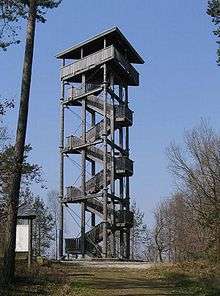
Kellerberg Observation Tower
In 1999 the 22-metre-high Kellerberg Observation Tower was built in a modern wood and steel design. The covered tower has a triangular plan and consists of seven larch logs that are connected by metal strips. The whole structure is tension with steel cables.[3] Its observation platform is 18 metres high and offers views far across the Eifel and to the Hunsrück. For example, Klausen and its pilgrimage church may be seen.
References
- 1 2 3 Map service of the Landscape Information System of the Rhineland-Palatinate Nature Conservation Office (Naturschutzverwaltung Rheinland-Pfalz)
- ↑ Map services of the Federal Agency for Nature Conservation
- ↑ Dierscheid, Aussichtsturm, Landesforsten Rheinland-Pfalz, auf wegezumholz.de