Kedarnath
| Kedarnath | |
|---|---|
| town | |
|
Kedarnath | |
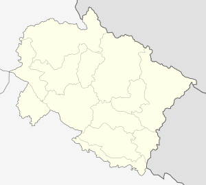 Kedarnath  Kedarnath Location in Uttarakhand, India | |
| Coordinates: 30°44′N 79°04′E / 30.73°N 79.07°ECoordinates: 30°44′N 79°04′E / 30.73°N 79.07°E | |
| Country | India |
| State | Uttarakhand |
| District | Rudraprayag |
| Elevation | 3,553 m (11,657 ft) |
| Population (2001) | |
| • Total | 479 |
| Language | |
| • Official | Hindi |
| Time zone | IST (UTC+5:30) |
| Vehicle registration | UK |
| Website |
uk |
Kedarnath is a town located in the Indian state of Uttarakhand and has gained importance because of Kedarnath Temple. It is a nagar panchayat in Rudraprayag district. The most remote of the four Chota Char Dham sites, Kedarnath is located in the Himalayas, about 3,583 m (11,755 ft) above sea level near Chorabari Glacier, the head of river Mandakini, and is flanked by snow-capped peaks. The nearest road head is at Gaurikund.
The town suffered extensive destruction during June 2013 from flash floods caused by torrential rains in Uttarakhand state.
Etymology
Kedarnath is named in the honour of King Kedar, who ruled in Satya Yuga. He had a daughter named Vrinda who was a partial incarnation of Goddess Lakshmi. She performed austerities for several years and the land is named after her as Vrindavan. However, Kedarnath and its temple exist from the Mahabharata era when the Pandavas are supposed to have pleased Lord Shiva by doing penance there. It is one of the most important dhams amongst the Chota Char Dham. The Shiva statue here is considered to be decapitated where as the head is believed to be in Doleshwor Mahadeva Temple in Bhaktapur, Nepal.
Location

Kedarnath is located at a distance of 223 km from Rishikesh in Uttarakhand and close to the source of Mandakini river at a height of 3,583 m (11,755 ft) above sea level.[1] The township itself cannot be called attractive, as it is built on a barren stretch of land on the shores of Mandakini river but the surrounding scenery of Himalayas and green pastures makes it a very attractive place for pilgrimage and trekking. Behind the town and Kedarnath temple, stands the majestic Kedarnath peak 6,940 m (22,769 ft), Kedar Dome 6,831 m (22,411 ft) and other peaks of the range.[1][2]
Demographics
As of 2001 India census,[3] Kedarnath had a population of 479. Males constitute 98% of the population and females 2%. Kedarnath has an average literacy rate of 63%: male literacy is 63%, and female literacy is 36%. In Kedarnath, none of the population is under 6 years of age. The floating population from May to October every year is more than 5000 per day.
Climate
During winter due to heavy snowfall, the Temple is closed and no one stays in Kedarnath. For six months (November to April) the Palki with the utsava murti of Lord Kedarnath is transferred to a place near Guptakashi called Ukhimath. People shift their settlement too from Kedarnath to nearby villages. Around 360 families of Tirtha Purohit of 55 villages and other nearby villages are dependent on Kedarnath for livelihood.
2013 flash floods
On 16 June 2013 at approximately 7:30 p.m., a landslide occurred near Kedarnath Temple with loud thunder followed by gushing of huge amount of waters from Chorabari Tal or Gandhi Tal down Mandakini River at about 8:30 p.m. which washed away everything in its path. On 17 June 2013 at approximately 6:40 a.m., waters rushed down River Saraswati and from Chorabari Tal or Gandhi Sarovar bringing along with its flow huge amount of silt, rocks and boulders. A huge boulder got stuck behind Baba Kedarnath Temple, protecting it from the ravages of the flood's fury. The flood water gushed on both sides of the temple destroying everything in its path.[4][5] Thus in the middle of pilgrimage season, torrential rains, cloud bursts and resulting flash floods nearly destroyed the town of Kedarnath. The town was the worst affected area by the floods.[6] Thousands of people were killed and thousands of others (mostly pilgrims) were reported missing or stranded due to landslides around Kedarnath. Although the surrounding area and compound of the Kedarnath temple were destroyed, the temple itself survived.[7][8] The Uttarakhand Chief Minister said that pilgrimage to Kedarnath would not be possible for next two to five years. The rescue operation resulted in more than 100,000 people being airlifted with the help of the Indian Army, Air force, NDRF and Indo-Tibet border police force. A helicopter (Mi 17) crashed during this exercise killing all 20 people on board (all of them were soldiers involved in relief and rescue work). The Air Force dropped logs to build pyres for mass cremations of the victims.[6] It was reported that previously uncollected bodies were still being found one year after the tragedy.[9]
Places of interest
Other than Kedarnath temple, on the eastern side of the town is Bhairava temple[1] and the deity of this temple, the Bhairava, is believed to protect the town during winter months. About 6 km upstream from the town, lies Chorabari Tal, a lake cum glacier also called Gandhi Sarovar.[1] Near Kedarnath, there is a cliff called Bhairav Jhamp, from where pilgrims used to jump to death, believed to get instant moksha or salvation and this practice was banned by British Government in the 19th century.[1]
Gallery
 The 14 km route to Kedarnath
 Bhairavnath Ji considered as the protector of the area
 View from hill top
 Horses on the hill near Kedarnath
 Lord-Kedarnath-Darshan-2014
See also
| Wikimedia Commons has media related to Kedarnath. |
References
- 1 2 3 4 5 Abram, David (2003). The Rough guide to India (2003 ed.). New York: Rough Guides. pp. 354–355. ISBN 9781843530893.
- ↑ Kala, CP (2014). "Deluge, disaster and development in Uttarakhand Himalayan region of India: challenges and lessons for disaster management". International Journal of Disaster Risk Reduction. 8: 143–152. doi:10.1016/j.ijdrr.2014.03.002.
- ↑ "Census of India 2001: Data from the 2001 Census, including cities, villages and towns (Provisional)". Census Commission of India. Archived from the original on 2004-06-16. Retrieved 2008-11-01.
- ↑ http://www.tehelka.com/what-happened-on-the-night-of-16th-june-inside-kedarnath-temple/
- ↑ http://in.news.yahoo.com/video/uttarakhand-floods-survivors-kedarnath-recount-082517606.html
- 1 2 http://www.economist.com/news/asia/21580209-natural-disaster-aggravated-poor-response-high-and-wet Floods in India: High and wet
- ↑ "Monsoon fury leaves Kedarnath shrine submerged in mud and slush". The Indian Express. 19 June 2013.
- ↑ "Thousands missing near Kedarnath shrine".
- ↑ "Exclusive: Dead bodies of pilgrims found in Kedarnath, one year after Uttarakhand tragedy", News Nation, 13 June 2014
- Dictionary of Hindu Lore and Legend (ISBN 0-500-51088-1) by Anna Dhallapiccola
- Helicopter Service for kedarnath
- Website for Kedarnath Information
-
 Kedarnath travel guide from Wikivoyage
 - Kedarnath Temple Photos
- Kedarnath Travel Guide
| History |  | |
|---|---|---|
| Deities | ||
| Texts | ||
| Mantra/ Stotra | ||
| Philosophies | ||
| Jyotirlingas | ||
| Temples | ||
| Traditions | ||
| ||