Kayenta, Arizona
| Kayenta, Arizona | |||||||
|---|---|---|---|---|---|---|---|
| CDP | |||||||
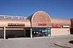
A panorama of Kayenta, downtown Kayenta in 2011, a Bashas' Diné store, the Kayenta Community School, the outskirts of Kayenta | |||||||
 Location in Navajo County and the U.S. state of Arizona | |||||||
 Kayenta, Arizona Location in the contiguous United States | |||||||
| Coordinates: 36°42′51″N 110°15′37″W / 36.71417°N 110.26028°WCoordinates: 36°42′51″N 110°15′37″W / 36.71417°N 110.26028°W | |||||||
| Country | United States of America | ||||||
| State | Arizona | ||||||
| County | Navajo | ||||||
| Government | |||||||
| • Chapter President | Stanley Clitso | ||||||
| Area | |||||||
| • Total | 34.3 km2 (13.2 sq mi) | ||||||
| • Land | 34.3 km2 (13.2 sq mi) | ||||||
| • Water | 0.0 km2 (0.0 sq mi) | ||||||
| Elevation | 1,738 m (5,700 ft) | ||||||
| Population (2010) | |||||||
| • Total | 5,189 | ||||||
| • Density | 143.5/km2 (393.1/sq mi) | ||||||
| Time zone | MST (UTC-7) | ||||||
| • Summer (DST) | MDT (UTC-6) | ||||||
| ZIP code | 86033 | ||||||
| Area code(s) | 928 | ||||||
| FIPS code | 04-36990 | ||||||
| GNIS feature ID | 0006627 | ||||||


Kayenta (Navajo: Tó Dínéeshzheeʼ) is a U.S. census-designated place (CDP) which is part of the Navajo Nation and is in Navajo County, Arizona. The population was 5,189 at the 2010 census. Kayenta is located 25 miles (40 km) south of Monument Valley and contains a number of hotels and motels which service visitors to Monument Valley. Like other places on the Navajo Nation, it is illegal to serve alcohol. Arizona does not observe Daylight Time; however, the Navajo reservation does.
Kayenta Township is the only municipal-style government on the Navajo Nation. It is regarded as a political sub-division of the Navajo Nation. It is managed by a five-member elected town board, which hires the township manager.
Kayenta is the name for the Chapter, as well as the township. Kayenta Chapter (a political division within the Navajo Nation that is analogous to a county within a state) encompasses land in both Utah and Arizona. Thus, the Navajo Nation's census figures for Kayenta Chapter are significantly different from those of Kayenta proper.
Kayenta also known as (Navajo: Toh-Den-Nas-Shai) meaning "Little fingers of running water". Similarly, like when it rains and the many drops run together; forming multiple little streams, that join larger streams.
Geography
Kayenta is located at 36°42′43″N 110°15′00″W / 36.71194°N 110.25000°W (36.7118, -110.2505), at an elevation of 5,700 feet, (1,738 m).
According to the United States Census Bureau, the CDP has a total area of 13.2 square miles (34 km2), all of it land.
Climate
According to the Köppen Climate Classification system, Kayenta has a semi-arid climate, abbreviated "BSk" on climate maps.[1]
Demographics
As of the census[2] of 2010, there were 5,189 people. The population density was 393.1 people per square mile (151.3/km2) with a total of 1,375 housing units. The racial makeup of the CDP was 92.27% Native American, 4.56% White, 0.25% Black or African American, 0.08% Asian, 0.02% Pacific Islander, 0.31% from other races, and 2.51% from two or more races. 1.97% of the population were Hispanic or Latino of any race.
In the CDP the population was spread out with 38.9% under the age of 18, 11.4% from 18 to 24, 11.9% from 25 to 34, 33.2% from 35 to 64, and 4.7% who were 65 years of age or older. The median age was 22 years. For every 100 females there were 90.7 males.
Events
The Kayenta Fourth of July Rodeo is an annual multi-day event taking place from July 1–4. Various events take place daily, while the "Best of the Best" and a fireworks show take place on the fourth. The Kayenta Fourth of July Rodeo has been recognized six times as the Rodeo of the Year and twice as the Outstanding Rodeo by the All Indian Rodeo Cowboys Association,[3] making it one of the premier rodeos to attend in the Southwest.
Education
Kayenta is served by the Kayenta Unified School District.
There are several schools that serve the community. Kayenta Elementary School, Kayenta Middle School, and Monument Valley High School are the public schools. Kayenta Community School, part of the Bureau of Indian Affairs, is a boarding school serving both day and dorm students.
Amenities
Restaurants
Kayenta is the home of several sit down and fast food restaurants, most of which are located at the junction between the 160 and the 163. In terms of fast food, Kayenta has a Burger King, Sonic Drive-In, Subway restaurant, and McDonald's. For casual dining there is the Golden Rice Bowl Chinese restaurant, Pizza Edge, Amigo Cafe, and The Blue Coffee Pot.
Groceries and shopping
A Bashas' Diné Market is located in Kayenta. Also found here are an Ace Hardware, a Video Plus movie rental store, as well as a Navajo Arts and Craft store. Kayenta does lack any kind of general merchandise store, like Wal-Mart or Target, that sells clothing and other amenties. The closest place with those would be Cortez, Colorado.
Lodging
Kayenta has three hotels serving travelers and passers by; the Weatherill Inn, Kayenta's Monument Valley Inn, and a Hampton Inn. The latter two being on US-160.
Local facilities
Kayenta has a large recreation center dedicated to serving the local community. Just outside the Recreation Center is a skating park, as well as an outdoor park with several playgrounds for children. Kayenta also has a movie theater, the Black Mesa Twin Cinema. On the east side of the community is a paved landing strip that can handle small single engine and twin engine aircraft used for air tours and air ambulance services.
Churches
Many religious organizations are represented in Kayenta. There are churches for Baptists, Presbyterian Church, Lamb of God Pentecostal Church, Potter's House Christian Church, Kayenta Church of Christ, The Living Word Assembly of God Church Assemblies of God, Catholic Church (Our Lady of Guadalupe), a meetinghouse for The Church of Jesus Christ of Latter-day Saints, and a Kingdom Hall for Jehovah's Witnesses. Also there is a Bible church located on the hill of Kayenta.
Miscellaneous
In terms of banking, there is a Wells Fargo located in Kayenta, as well as a Western Union, and an H&R Block. There is a U.S. post office in Kayenta. There is one movie rental location, a NAPA auto and truck parts store, and an Urban Trendz haircut place.
In popular culture
- An abridged depiction of Kayenta is featured in the 2016 Czech video game, American Truck Simulator
See also
References
- ↑ Climate Summary for Kayenta, Arizona
- ↑ "American FactFinder". United States Census Bureau. Retrieved 2008-01-31.
- ↑ "Kayenta Fourth of July Rodeo Set To Become Premier Southwest Event". Kayenta Rodeo. Kayenta Township. May 29, 2009. Retrieved 2009-12-08.
External links
| Wikimedia Commons has media related to Kayenta, Arizona. |
| Cities | 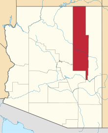 | |
|---|---|---|
| Towns | ||
| CDPs |
| |
| Unincorporated communities | ||
| Indian reservations | ||
| Ghost towns | ||
| Footnotes | ‡This populated place also has portions in an adjacent county or counties | |