Kapowsin, Washington
| Kapowsin | |
|---|---|
| census-designated place (CDP) | |
 Kapowsin Location within the state of Washington | |
| Coordinates: 46°59′08″N 122°13′32″W / 46.98556°N 122.22556°WCoordinates: 46°59′08″N 122°13′32″W / 46.98556°N 122.22556°W | |
| Country | United States |
| State | Washington |
| County | Pierce |
| Population (2010) | |
| • Total | 333 |
| Time zone | Pacific (PST) (UTC-8) |
| • Summer (DST) | PDT (UTC-7) |
Kapowsin is a census-designated place located approximately 25 miles (38 kilometers) southeast of Tacoma in Pierce County, Washington, United States. The 2010 Census placed the population at 333.
Kapowsin was founded in 1901 when the Kapowsin Lumber Company built a sawmill at the community's present site.[1] Located on the north end of Lake Kapowsin, the community was a thriving lumber town in the early part of the 20th century, with a high school, shops, and trades, and a population of about 10,000. After a decline in the timber industry, the town diminished in size into a neighborhood center, with a store, tavern, post office (US ZIP code 98344), fire station and grange hall. Kapowsin High School was abandoned in 1949 after being damaged in an earthquake.
Kapowsin is located partially in the Bethel School District and partially in the Eatonville School District, and Kapowsin Elementary School is located nearby. Secondary students attend Frontier Junior High and Graham-Kapowsin High School, which opened in 2005. Tacoma Rail's freight line to Morton, Washington, runs through the town.
References
- ↑ Majors, Harry M. (1975). Exploring Washington. Van Winkle Publishing Co. p. 122. ISBN 978-0-918664-00-6.
Municipalities and communities of Pierce County, Washington, United States | ||
|---|---|---|
| Cities | 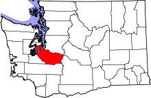 | |
| Towns | ||
| CDPs |
| |
| Other unincorporated communities | ||
| Indian reservation | ||
| Military bases | ||
| Ghost towns | ||
| Footnotes | ‡This populated place also has portions in an adjacent county or counties | |