Kangiqsujuaq
For the Inuit reserved land of the same name, see Kangiqsujuaq (Inuit reserved land).
| Kangiqsujuaq ᑲᖏᖅᓱᔪᐊᖅ | |
|---|---|
| Northern village municipality | |
 | |
 Kangiqsujuaq | |
| Coordinates (901, chemin Sinaitia[1]): 61°36′N 71°58′W / 61.600°N 71.967°WCoordinates: 61°36′N 71°58′W / 61.600°N 71.967°W[2] | |
| Country |
|
| Province |
|
| Region | Nord-du-Québec |
| TE | Kativik |
| Constituted | September 20, 1980 |
| Government[1] | |
| • Mayor | Mary A. Pilurtuut |
| • Federal riding | Abitibi—Baie-James—Nunavik—Eeyou |
| • Prov. riding | Ungava |
| Area[1][3] | |
| • Total | 12.60 km2 (4.86 sq mi) |
| • Land | 12.56 km2 (4.85 sq mi) |
| Population (2011)[3] | |
| • Total | 696 |
| • Density | 55.4/km2 (143/sq mi) |
| • Change (2006–11) |
|
| • Dwellings | 174 |
| Time zone | EST (UTC−5) |
| • Summer (DST) | EDT (UTC−4) |
| Postal code(s) | J0M 1K0 |
| Area code(s) | 819 |
| Website |
www |
Kangiqsujuaq (Inuktitut: ᑲᖏᖅᓱᔪᐊᖅ) is a northern village (Inuit community) in Nunavik, Nord-du-Québec, Quebec, Canada. It had a population of 696 in the Canada 2011 Census. The community has also been known as Wakeham Bay. The name "Kangiqsujuaq" means "the large bay" in Inuktitut.
It is located on the Ungava Peninsula, on the Cap du Prince-de-Galles on the Hudson Strait. It is served by the small Kangiqsujuaq Airport.
During winter, when the tides are extremely low, local Inuit sometimes climb beneath the shifting sea ice to gather mussels. They break holes in the ice and then can walk for a short time on the exposed sea bed and collect this food. This risky way of gathering the mussels goes back for generations.[4]
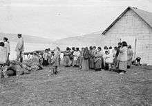
Révillon Frères post servants at Kangiqsujuaq in 1909.
References
- 1 2 3 Geographic code 99130 in the official Répertoire des municipalités (French)
- ↑ Reference number 98662 of the Commission de toponymie du Québec (French)
- 1 2 "(Code 2499130) Census Profile". 2011 census. Statistics Canada. 2012.
- ↑ "Inuit's risky mussel harvest under sea ice". BBC News. 25 January 2011. Retrieved 25 January 2011.
External links
This article is issued from Wikipedia - version of the 11/27/2015. The text is available under the Creative Commons Attribution/Share Alike but additional terms may apply for the media files.