Kampong Ayer

Kampong Ayer, or the Water Village (Malay: Kampung Air) is an area of Brunei's capital city Bandar Seri Begawan that is situated over Brunei Bay. 39,000 people live in the Water Village. This represents roughly ten percent of the nation's total population. All of the Water Village buildings are constructed on stilts above the Brunei River.
History
Antonio Pigafetta described the village in 1521: "that city is entirely built in salt water, except the houses of the king and certain chiefs. It contains twenty-five thousand hearths. The houses are all constructed of wood and built up from the ground on tall pillars. When the tide is high women go in boats through the settlement selling articles necessary to maintain life". It is possible that the village moved over time, for over more than a thousand years, following the location of the Brunei capital. Olivier van Noort described his visit in December 1600 - January 1601 and said that Brunei palaces: "could be called beautiful houses, albeit they are made of wood, and built on such light piles that where there is a storm or some other untoward event these houses can be removed from one side of the river to the other ...". Initially the capital was closer to the mouth of the Brunei River at Kota Batu and moved further inland to its current location during the civil war between Abdul Hakkul Mubin and Muhyiddin Brunei sultans in 17th century.[1] The development of the current capital Bandar Seri Begawan began in 1906 when the first British resident of Brunei ( Malcolm Stewart Hannibal McArthur ) stated that he "wanted a clean dry village, with suburbs of kampong houses" and encouraged people to settle on the western river bank land. Till then, Kampong Ayer has been the capital of the Brunei Sultanate for hundreds of years. [2] The establishment of the land town acting as a population magnet did not lead to the depopulation of Kampong Ayer. Arrival of new residents and natural increase maintained the population balance. Most of Kampong Ayer had survived heavy World War II bombardments.[3]
Development
As part of His Majesty's plans to improve the standard of living for the population in Kampong Ayer, King Hassanal Bolkiah decreed to build modern, two story stilt houses made of concrete in the center of the Kampong Ayer starting around 2013-2014. These houses would be given to the people in need of a new house not wishing to live on land.
Overview
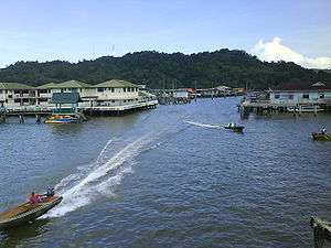
Built entirely of stilt houses and wooden walkways, this cluster of 42 villages housing more than 30,000 inhabitants is the world's largest water village. [4]

The Water Village is really made up of small villages linked together by more than 29,140 meters of foot-bridges, consisting of over 4200 structures including homes, mosques, restaurants, shops, schools, and a hospital. 36 kilometers of boardwalks connect the buildings. Private water taxis provide rapid transit. Most of these taxis resemble long wooden speed boats. From a distance the water village looks like a slum. It actually enjoys modern amenities including air conditioning, satellite television, Internet access, plumbing, and electricity. Some of the residents keep potted plants and chickens. The district has a unique architectural heritage of wooden homes with ornate interiors. The villages in Water Village are Mukim Sungai Kedayan including Bukit Salat, Sumbiling Lama, Sungai Kedayan 'A', Sungai Kedayan 'B', Ujong Tanjong and Kuala Peminyak; Mukim Tamoi including Tamoi Ujong, Tamoi Tengah, Pengiran Kerma Indera Lama, Pengiran Tajuddin Hitam, Ujong Bukit/Limbongan, Pengiran Bendahara Lama; Mukim Burong Pingai Ayer including Burong Pingai Ayer, Lurong Dalam, Pandai Besi 'A', Pandai Besi 'B', Sungai Pandan 'A', Sungai Pandan 'B', and Pengiran Setia Negara, Pekan Lama; Mukim Peramu including Peramu, Pekilong Muara, Bakut Pengiran Siraja Muda ' A', Bakut Pengiran Siraja Muda 'B', Bakut Berumput and Lurong Sikuna; Mukim Saba including Saba Tengah, Saba Ujong, Saba Laut, Saba Darat 'A' and Saba Darat 'B'. Mukim Sungai Kebun including Setia 'A', Sungai Siamas/Ujong Klinik, Setia 'B' Sungai Kebun, Bolkiah 'A' and Bolkiah 'B'.
People have lived in Kampong Ayer for over 1300 years. Antonio Pigafetta dubbed it the "Venice of the East" when the fleet of Ferdinand Magellan visited in 1521.[5] The district is a culturally important part of Brunei that preserves the nation's river dwelling origins. According to geography professor Abdul Aziz of the Universiti Brunei Darussalam, this is the largest and most famous water settlement of Southeast Asia. "It was historically the very core of Brunei and one of the most important centres of trade in Borneo."[6]
In order to preserve Kampong Ayer as Brunei Darussalam's most valuable heritage, the Government through the District Office has provided it with numerous facilities including foot-bridges, concrete jetties, piped water, electricity supplies telephones, a school, mosques, clinics, a police station and a marine fire station. All of the six water village mukims (districts) are collectively known as the water village (Kampong Ayer) but are identified as separate mukims for administrative purposes.
Visitors can have a personal experience of this heritage by taking one of the many water taxis that ply daily between the water taxi jetty in front of the Yayasan Sultan Haji Hassanal Bolkiah in the centre of town and the water village itself.[7]
References
- ↑ Yunos, Rozan (2011-04-25). "Tracing the history of today's Kampong Ayer". The Brunei Times.
- ↑ Yunos, Rozan (2009-01-18). "Retracing history of streets of Bandar". The Brunei Times.
- ↑ S. C. Chi (1994). The changing socio-economic profile of Kampong Ayer, Negara Brunei Darussalam. Faculty of Arts and Social Sciences, Universiti Brunei Darussalam. p. 65.
- ↑ "Brunei Tourism". BRUNEIresources.com. Retrieved 2011-08-10.
- ↑ Wilson, Robert. "Brunei: The Abode of Peace". Jadedragon.com. Retrieved 2011-08-10.
- ↑ "Asia Times: Old water village drowning in modern problems". Atimes.com. 1999-03-26. Retrieved 2011-08-10.
- ↑ "Brunei Tourism". BRUNEIresources.com. Retrieved 2011-08-10.
Coordinates: 4°55′0″N 114°55′0″E / 4.91667°N 114.91667°E