Kamiak Butte
| Kamiak Butte County Park | |
|---|---|
|
The southern slopes of Kamiak Butte, with wheat fields beyond | |
| Location | Whitman County, Washington, USA |
| Coordinates | 46°51′56″N 117°09′49″W / 46.8654447°N 117.1635063°WCoordinates: 46°51′56″N 117°09′49″W / 46.8654447°N 117.1635063°W [1] |
| Area | 298 acres (121 ha) |
| Operated by | Whitman County Parks and Recreation Department |
| Designated | 1965 |

Kamiak Butte County Park is located in Whitman County, Washington between the towns of Palouse and Pullman in Eastern Washington, near the border of Idaho. It is named after Chief Kamiakin of the Yakama tribe.
Most of the park's 298 acres (121 ha) consist of timberland on the northern slopes of Kamiak Butte. The mountain itself is an "island," consisting of Precambrian quartzite projecting approximately 1,000 feet (300 m) above the surrounding wheat fields. The reddish rocks once formed the bed of an ancient sea, and the grains of sand embedded in them can still be seen glittering in the sun. Later in its geological history, Kamiak Butte became part of a mountain range which was eventually nearly engulfed by the Cenozoic lava flows that covered most of Eastern Washington in a layer of basalt.
The region's intensive wheat and lentil farming has made Kamiak Butte an important haven for indigenous plant and animal species. 170 plant species, 130 bird species, and 30 mammal species have been observed inside the park.
For most visitors, the park's chief attraction is the Pine Ridge Trail, a 3.5-mile (5.6 km) loop which begins at a parking area and climbs through evergreen forestland to an exposed ridge. The trail continues along the ridge, affording spectacular views of the surrounding palouse country before dropping back into the forest. A short "summit spur" leads to the mountain's highest point - a rocky promontory on the west side with an elevation of 3,641 feet (1,110 m). Camping is available all year, except during periods of drought, when it is often prohibited due to fire danger. Interpretive programs are offered in the spring and summer months; other amenities include an amphitheater, picnic tables, outdoor grills, covered shelters, restrooms, and a playground.
For ham/amateur radio operators, two linked repeaters are near the top of the mountain.The frequencies are 146.74 MHz, with a 600 kHz negative offset (the 2 meter repeater), and 53.75 MHz, with a 1.7 MHz negative offset, and a PL Tone of 100 Hz (the 6 meter repeater). The repeaters are also part of Washington State's Evergreen Intertie, a statewide amateur radio repeater/emergency communications linking system.[2]
Kamiak Butte, together with Steptoe Butte, is a National Natural Landmark,[3] and Pine Ridge Trail is listed as a National Recreation Trail within the National Trails System.[4]
Images
-
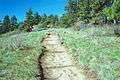
Pine Ridge Trail on Kamiak Butte
-
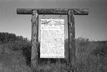
Kamiak Butte information sign
-
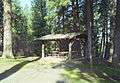
Picnic table at Kamiak Butte
References
- ↑ "Kamiak Butte County Park". Geographic Names Information System. United States Geological Survey.
- ↑ "Evergreen Intertie".
- ↑ "National Registry of Natural Landmarks" (PDF). National Natural Landmarks Program. June 2009. p. 103. Retrieved 2014-08-13.
- ↑ "Pine Ridge". National Recreation Trails Program. Retrieved 2014-08-13.
External links
- "Self Guiding Nature Walk for the Pine Ridge Trail at Kamiak Butte". Whitman County Parks and Recreation Department.
- "Kamiak Butte County Park". Whitman County.
- "The Plants of Kamiak Butte". Marion Ownbey Herbarium, Washington State University.