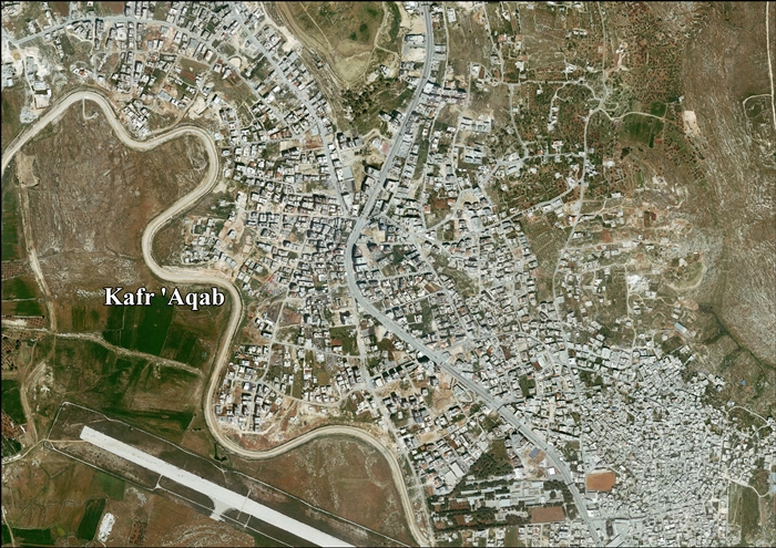
Kafr 'Aqab
| Kafr 'Aqab | |
|---|---|
| Other transcription(s) | |
| • Arabic | كفر عقب |
|
Kfar 'Aqab, 2013 | |
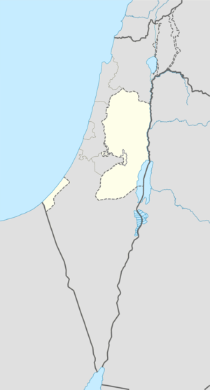 Kafr 'Aqab Location of Kafr 'Aqab within the Palestinian territories | |
| Coordinates: 31°52′33″N 35°13′11″E / 31.87583°N 35.21972°ECoordinates: 31°52′33″N 35°13′11″E / 31.87583°N 35.21972°E | |
| Governorate | Jerusalem |
| Government | |
| • Type | Municipality |
| Population (2006) | |
| • Jurisdiction | 10,411 |

Kafr 'Aqab (Arabic: كفر عقب) is the northernmost Palestinian Arab neighborhood in East Jerusalem. It is located within the municipal boundaries of Jerusalem and two kilometers from Ramallah.[1]
According to a census conducted in 1931 by the British Mandate authorities, Kafr Aqab had a population of 250, in 59 houses.[2] According to the Palestinian Central Bureau of Statistics, in 2006, Kafr 'Aqab had a population of 10,411.[3] Primary health care for Kafr 'Aqab is obtained in Al-Ram.[4] In 2007, Kfar 'Aqab was described as a middle class suburb.[5]
While Kafr 'Aqab was annexed with the rest of East Jerusalem by Israel and falls under its full jurisdiction, it is separated from Jerusalem by the Israeli West Bank barrier. Municipal inspectors never inspect the area beyond the barrier. This creates "a planning nightmare and developer's dream".[6]
The al-Faruq mosque in Kafr 'Aqab offers weekly classes in the Islamic teachings of Hizb ut-Tahrir.[7]
References
- ↑ Israeli, Palestinian boys soccer tournament exposes reality of Jerusalem life
- ↑ Mills, 1932, p. 37
- ↑ Projected Mid -Year Population for Jerusalem Governorate by Locality 2004- 2006 Palestinian Central Bureau of Statistics.
- ↑ West Bank Healthcare
- ↑ Palestinians back caliphate over politics
- ↑ Israeli, Palestinian boys soccer tournament exposes reality of Jerusalem life
- ↑ Palestinians back caliphate over politics
Further reading
| Wikimedia Commons has media related to Kafr 'Aqab. |
- Barron, J. B., ed. (1923). Palestine: Report and General Abstracts of the Census of 1922. Government of Palestine.
- Conder, Claude Reignier; Kitchener, H. H. (1883). The Survey of Western Palestine: Memoirs of the Topography, Orography, Hydrography, and Archaeology. 3. London: Committee of the Palestine Exploration Fund. (pp. 10 -11 )
- Hadawi, Sami (1970). Village Statistics of 1945: A Classification of Land and Area ownership in Palestine. Palestine Liberation Organization Research Center.
- Hütteroth, Wolf-Dieter; Abdulfattah, Kamal (1977). Historical Geography of Palestine, Transjordan and Southern Syria in the Late 16th Century. Erlanger Geographische Arbeiten, Sonderband 5. Erlangen, Germany: Vorstand der Fränkischen Geographischen Gesellschaft. ISBN 3-920405-41-2. (p. 118)
- Mills, E., ed. (1932). Census of Palestine 1931. Population of Villages, Towns and Administrative Areas. Jerusalem: Government of Palestine.
- Morris, Benny (2004). The Birth of the Palestinian Refugee Problem Revisited. Cambridge University Press. ISBN 978-0-521-00967-6. (p. 80)
- Palmer, E. H. (1881). The Survey of Western Palestine: Arabic and English Name Lists Collected During the Survey by Lieutenants Conder and Kitchener, R. E. Transliterated and Explained by E.H. Palmer. Committee of the Palestine Exploration Fund. (p. 297)
- Robinson, Edward; Smith, Eli (1841). Biblical Researches in Palestine, Mount Sinai and Arabia Petraea: A Journal of Travels in the year 1838. 2. Boston: Crocker & Brewster. (p. 315 )
- Röhricht, Reinhold (1893). (RRH) Regesta regni Hierosolymitani (MXCVII-MCCXCI) (in Latin). Berlin: Libraria Academica Wageriana. (Röhricht, 1893, RRH, pp. 16-17, No 74)
- de Roziére, ed. (1849). Cartulaire de l'église du Saint Sépulchre de Jérusalem: publié d'après les manuscrits du Vatican (in Latin and French). Paris: Imprimerie nationale. (p. 30: Cafareab, p. 262: Keffreca. Cited in Röhricht, 1893, RRH, pp. 16-17, No 74)
- Socin, A. (1879). "Alphabetisches Verzeichniss von Ortschaften des Paschalik Jerusalem". Zeitschrift des Deutschen Palästina-Vereins. 2: 135–163. (p. 156 )
External links
- Pockets of Lawlessness in the "Oasis of Justice", Candace Graff, 2014, Jerusalem Quarterly, Institute for Palestine Studies
- Welcome to Kafr 'Aqab
- Survey of Western Palestine, Map 17: IAA, Wikimedia commons
- Kafr 'Aqab village (fact sheet)
- Kafr 'Aqab village profile
- Kafr 'Aqab aerial photo

Neighborhoods of Jerusalem | ||
|---|---|---|
Jerusalem neighborhoods east of the 1949 armistice line are depicted in green, those west of the line in blue (see Green Line). | ||
| Old City |  | |
| Central Neighborhoods |
| |
| Northern Neighborhoods | ||
| Eastern Neighborhoods | ||
| Southern Neighborhoods | ||
| Western Neighborhoods | ||
| Historical Neighborhoods | ||
| ||