Kafir Kot
Kafir Kot (or Kafirkot) is an ancient ruin in Dera Ismail Khan District, Khyber Pakhtunkhwa. According to the district Gazetteer of Mianwali of 1915 the remains of Kafirkot (and the nearby ruin of Mari) "are indication of the existence of a Hindu civilization of considerable importance and antiquity".[1] It is located at 32°30'0N 71°19'60E[2]
Description
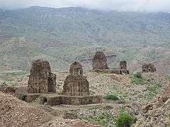
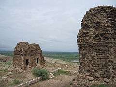
The ruin consists of two forts in the north-west of the district on small hills attached to the lower spurs of the Khasor Range, and overlooking the Indus River. One lies a few miles south of Kunda] and the other near Bilot.[1]
According to the District Gazetteer of Mianwali:
| “ |
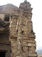
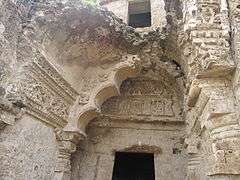
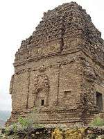
These forts are of great antiquity and interest. Their main features are an outer defensive wall, consisting of rough blocks of stone, some of great size, and various groups of buildings resembling small Hindu temples and more or less carved. These are built of a curiously honey-combed drab-coloured stone not to be found in the adjacent hills, which is said to have been brought by river all the way from Khushalgarh. The area of the forts is considerable and they could have held a fairly large garrison. The only legends attached to them relate that they were occupied by the last of the Hindu Rajas, Til and Bil; but all traces of rulers and ruled are now lost.[1] |
” |
Location
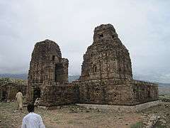
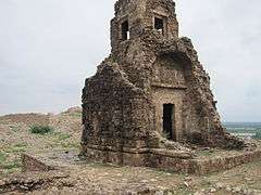
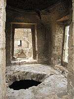
Bilot Fort is the second fort situated next to the town of Bilot Sharif and about 55 km north of Dera Ismail Khan in Pakistan. It was an ancient Hindu Fort with a famous temple inside its walls. The fort has disintegrated over time but the temple still stands.
Museum collections
Sculptures and architectural components from the site have been dispersed to museums across Pakistan and the rest of the world. One of the largest collections from Kafir Kot outside Pakistan is in the British Museum.[3]
| Images of Bilot Fort and the standing temple |
|---|
| View of the Hindu Temples |
| Some amount of restoration work has been done on the temple |
| The walls of the temple are made of porous rock |
| Fine work on the walls and ceilings |
| Stairs up the temple lead to an opening |
| View from the upper floor of a temple |
| One of the well preserved temple rooms |
|
References
External links
|
|---|
|
| Forts | |
|---|
|
| Archaeological sites | |
|---|
|
| Museums | |
|---|
Coordinates: 32°30′0″N 71°20′0″E / 32.50000°N 71.33333°E / 32.50000; 71.33333