Kadina, South Australia
| Kadina South Australia | |||||||||||||
|---|---|---|---|---|---|---|---|---|---|---|---|---|---|
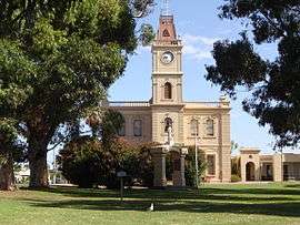 Kadina Town Hall | |||||||||||||
 Kadina | |||||||||||||
| Coordinates | 33°57′45″S 137°42′45″E / 33.96250°S 137.71250°ECoordinates: 33°57′45″S 137°42′45″E / 33.96250°S 137.71250°E | ||||||||||||
| Population | 4,470 (2011 census)[1] | ||||||||||||
| Established | 1861 | ||||||||||||
| Postcode(s) | 5554 | ||||||||||||
| Elevation | 44 m (144 ft) | ||||||||||||
| Location | 144 km (89 mi) NNW of Adelaide | ||||||||||||
| LGA(s) | Copper Coast | ||||||||||||
| State electorate(s) | Goyder | ||||||||||||
| Federal Division(s) | Grey | ||||||||||||
| |||||||||||||
| |||||||||||||


Kadina is a town located on the Yorke Peninsula of South Australia, approximately 144 kilometres north-northwest of the state capital of Adelaide. The largest town of the Peninsula, Kadina is one of the three Copper Triangle towns famous for their shared copper mining history. The three towns are known as "Little Cornwall" for the significant number of immigrants from Cornwall that worked at the mines in the late 19th century.
It is about 20 kilometres (12 mi) north-east of Moonta and 8 kilometres (5.0 mi) east of the port town of Wallaroo. There are 6 suburbs making up Kadina's township, each being a distinct historic locality or hamlet. These are: Jericho, Jerusalem, Matta Flat, New Town and Wallaroo Mines as well as central Kadina itself.[2] Kadina East was previously a suburb east of Kadina's centre.[2]
The name "Kadina" is thought to be derived from Kadiyinya, an (indigenous) Narungga tribe word meaning 'Lizard Plain'.
The town is the base for local radio station Gulf FM, broadcasting at 89.3 FM.
History
Copper was discovered at Wallaroo Mines in 1859 and adjacent land north east of the site was surveyed in 1861 to house miners. The township was named Kadina. Exceptional amounts of copper were found in the following years. Copper was also found in large amounts at the nearby Matta Mine and Doora Mine. The copper mines attracted many highly experienced Cornish miners to Kadina. In 1872 Kadina became a municipality and by 1875 the population had increased to 20,000, mostly composed of Cornish miners.
In 1862 a horse-drawn railway was opened from Kadina to the port at Wallaroo west of the town.[3] Further lines connecting Kadina to Port Wakefield to the southeast and Bute to the northeast opened in 1878 and 1879[4] respectively.[5] These rail lines fell into disuse and were closed in 1989. Mining ceased completely in 1938.
The town today consists of important historical colonial and federation buildings gathered around Victoria Square. Kadina and its surrounds are experiencing some minor growth due to the Copper Cove housing development at Wallaroo.
Kadina also contains the Farm Shed Museum & Tourism Centre (Kadina Heritage Museum) and remnants of the Wallaroo Mines. Kernewek Lowender, a Cornish festival, is held every odd year in May in Kadina (as well as Moonta and Wallaroo where each location hosts the festival for one day)
Heritage listings
Kadina has a number of heritage-listed sites, including:
- Drain Road: Kadina Cemetery [6]
- 36-38 Taylor Street: Humphries Barber Shop [7]
- 51 Taylor Street: Kadina Town Hall [8]
Geography and climate
Kadina exists in a semi-arid location, above Goyder's Line, and is surrounded by mallee scrub. It is located 8 kilometres inland and 44 metres above sea level. Kadina has a dry Mediterranean climate with seasonal temperatures a few degrees above Adelaide's temperatures. The average winter temperature is 15.4 °C and the average summer temperature is 30.5 °C. Average rainfall of Kadina is 388.8 millimetres. The weather patterns are similar to those of Adelaide.
Kadina's surrounds are used for growing barley, wheat and other crops such as legumes, canola, chickpeas and field peas. Barley and wheat from the region is considered to be some of the best in the world.
Governance
The District Council of the Copper Coast governs Kadina at the municipal level. Kadina lies in the state electoral district of Goyder and the federal electoral Division of Grey.
Notable people from Kadina
- Richard Champion (b. 1968), former AFL footballer
- John Olsen (b. 1945), former South Australian Premier and South Australian Federal Senator
- Horace Wilson (1864-1923), cricketer
- Oliver Badman (1885-1977), politician
- Rex Pearson (1905-1961), politician
- Cameron Sutcliffe (b.1992), AFL Footballer
- Lynton Crosby (b.1957), political strategist
- Steve Prestwich (1954-2011), musician
See also
- Wallaroo, South Australia
- Moonta, South Australia
- Cornish emigration
- Kernewek Lowender
- District Council of Northern Yorke Peninsula
References
- ↑ Australian Bureau of Statistics (31 October 2012). "Kadina (Urban Centre/Locality)". 2011 Census QuickStats. Retrieved 21 April 2014.
- 1 2 "Property Location Browser (Search: Moonta, LOCB)". Government of South Australia. Retrieved 1 February 2016.
- ↑ "PORT WALLAROO. From our own Correspondent (July 7)". South Australian Weekly Chronicle. 12 July 1862. p. 3.
- ↑ "THE KADINA AND BARUNGA RAILWAY.". South Australia Chronicle and Weekly Mail. 8 March 1879. p. 7.
- ↑ Callaghan, W.H. (February 2002). "Horse and Steam, Wheat and Copper". Australian Railway Historical Society Bulletin: 9-27; 46-63.
- ↑ "Kadina Cemetery, including the Mortuary and Wall". South Australian Heritage Register. Department of Environment, Water and Natural Resources. Retrieved 17 May 2016.
- ↑ "Former Humphries Barber Shop (former Hancock's Barber Shop and Billiard Saloon)". South Australian Heritage Register. Department of Environment, Water and Natural Resources. Retrieved 17 May 2016.
- ↑ "Kadina Town Hall (incorporating 1880 Mechanics Institute)". South Australian Heritage Register. Department of Environment, Water and Natural Resources. Retrieved 17 May 2016.
External links
| Wikimedia Commons has media related to Kadina, South Australia. |
| Major Townships | |||||||||||
|---|---|---|---|---|---|---|---|---|---|---|---|
| Minor Townships | |||||||||||
| Governance |
| ||||||||||
| Coastal features | |||||||||||
| Protected areas |
| ||||||||||
| Islands adjoining the Yorke Peninsula coast | |||||||||||
| Related and uncategorised | |||||||||||
| |||||||||||