Jungnangcheon
| Jungnang (중랑천/中浪川) | |
| River | |
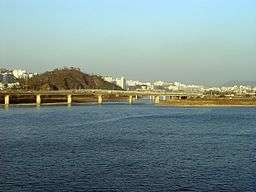 The Jungnangcheon entering the River Han. | |
| Country | South Korea |
|---|---|
| Provinces | Gyeonggi, Seoul |
| Tributaries | |
| - left | Cheonggyecheon |
| Source | Bulgok Mountain [lower-alpha 1] |
| - location | Yangju, Gyeonggi |
| Mouth | Han River |
| - location | Seongdong, Seoul |
| Length | 36.44 km (23 mi) [1] |
| Basin | 296.87 km2 (115 sq mi) [1] |
| Jungnangcheon | |
| Hangul | 중랑천 |
|---|---|
| Hanja | 中浪川 |
| Revised Romanization | Jungnangcheon |
| McCune–Reischauer | Chungnangch'ŏn |
The Jungnangcheon (hangul: 중랑천) is a tributary of Seoul's Han River. It is generated in the valley of Dorak Mountain of Yangju, Gyeonggi-do. Cheonggyecheon is a tributary of Jungnangcheon. Its whole river basin extends to 299.9 km². Most of the stream is located in Uijeongbu and Seoul.
Recreation
Citizens enjoy jogging and cycling near the river. The cycling track links to other tracks on both the nearby Cheongyecheon stream and the Han river.
Seoul Selection reports that there are some areas alongside the stream where rape flowers are visible in May.[2]
Pollution
The river contains a large amount of pollutants especially from domestic pollution. Experts have pointed out that the pollution originates from the upper reaches of the stream. In summer 2007, more than 200 fish died after a heavy rain. Pollutants at the bottom of the riverbed contaminated the stream after a storm, and citizens called environmental authorities.
Uijeongbu city government reported its plan to build more ecologically-friendly sewage disposal plants.
Despite the likelihood that the water is not clean, many people fish in the river downstream from Uijeongbu.
See also
Notes
- 1 2 2013년 한국하천일람 [List of Rivers of South Korea, 2013] (PDF) (in Korean). Han River Flood Control Office, Republic of Korea. 31 December 2012. pp. 108–109. Retrieved 2 July 2014.
- ↑ Seoul Selection 'Seoul's Flower Roads' April 4, 2009 Issue 367
Korean text informations
Coordinates: 37°33′N 127°02′E / 37.550°N 127.033°E