Jostedal Glacier
| Jostedal Glacier | |
|---|---|
|
Jostedalsbreen glacier | |
 | |
| Type | Mountain glacier |
| Coordinates | 61°42′38″N 06°55′27″E / 61.71056°N 6.92417°ECoordinates: 61°42′38″N 06°55′27″E / 61.71056°N 6.92417°E |
| Area | 487 km2 (188 sq mi) |
| Length | 60 km (37 mi) |
| Thickness | 600 m (2,000 ft) |
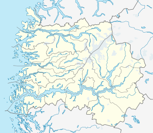
Jostedal Glacier (Norwegian Jostedalsbreen) is the largest glacier in continental Europe. It is situated in Sogn og Fjordane county in Western Norway.[1] Jostedalsbreen lies in the municipalities of Luster, Sogndal, Jølster, and Stryn. The highest peak in the area is Lodalskåpa at a height of 2,083 metres (6,834 ft).
History
In 1906 work was being done on footpaths that could accommodate tourists.[2]
Geography
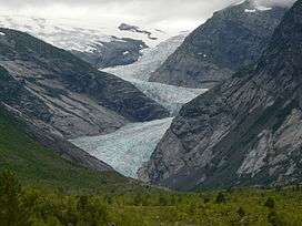
Jostedal Glacier has a total area of 487 square kilometres (188 sq mi). The highest point is Høgste Breakulen at 1,957 metres (6,421 ft) above mean sea level. Branches of the glacier reach down into the valleys, for instance Bøyabreen in Fjærland and Nigardsbreen, both at 300 metres (980 ft) above sea level. The thickest part of the glacier is 600 metres (2,000 ft). Jostedalsbreen has a length of a little more than 60 kilometres (37 mi) and it is a part of the 1,310-square-kilometre (510 sq mi) Jostedalsbreen National Park, which was established in 1991. The glacier covers over half of the national park.[1]
The glacier is maintained by the high snowfall rates in the region, not the cold temperatures. This means the glacier has high melting rates in its snouts. The Jostedalsbreen has around 50 glacier arms such as the Nigardsbreen and Tunsbergdalsbreen in Jostedal, the Briksdalsbreen near Olden, the Bøyabreen by Fjærland, the Kjenndalsbreen and Tindefjellbreen near Loen, and Austerdalsbreen.[1]
In 2012, the glacier arm Briksdalsbreen lost 50 metres (160 ft) of ice in a few months. More recent measurements now show that Briksdalsbreen retreated 146 metres (479 ft) in 2006, and could be in danger of breaking away from the upper icefield. Ice climbing has now been terminated because of this event.
See also
References
- 1 2 3 Luhr, James F., ed. (2003). Illustrated Encyclopedia of the Earth. Dorling Kindersley. ISBN 978-1-4053-3270-5.
- ↑ Med handmakt i den stupbratte fjellsida legg sherpaene ny sti opp til Jostedalsbreen [By hand-force the sherpas prepare a new path in the steep mountainside leading up to the Jostedal Glacier]
Further reading
- Dyer, Anthony; Robertson, Ian H.; Baddeley, John (2006). Walks and Scrambles in Norway. United Kingdom: Rockbuy Limited. ISBN 978-1-904466-25-3.
- Slingsby, William Cecil (2003). Norway: the Northern Playground. Rockbuy Limited. ISBN 978-1-904466-07-9.
- Wold, Bjørn; Ryvarden, Leif (1996). Jostedalsbreen, Norway's Largest Glacier. Oslo, Norway: J. W. Cappelens Forlag AS. ISBN 978-82-7683-092-7.
External links
| Wikimedia Commons has media related to Jostedalsbreen. |
- Jostedalsbreen National Park Centre
- Jostedal Glacier National Park
- Directorate for Nature Management - National Parks