Josephinian Land Survey
Distribution and time periods of the Josephinian Land Survey
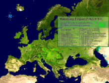
The Josephinian Land Survey (Josephinische Landesaufnahme) was the first comprehensive land survey and mapping of the Habsburg Empire. The survey was ordered by Holy Roman Empress Maria Theresa after Austria's defeat in the Seven Years' War.[1][2] It was conducted from 1763 to 1787, concluding in the reign of Holy Roman Emperor Joseph II. The maps are currently stored in the National Archives of Austria.
References
- ↑ Ivan Bičík, Lucie Kupková, Leoš Jeleček, Jan Kabrda, Přemysl Štych, Zbyněk Janoušek, Jana Winklerová (2015). Land Use Changes in the Czech Republic 1845–2010. Springer. pp. 73–74. ISBN 978-3-319-17670-3.
- ↑ Kain, Roger J. P.; Baigent, Elizabeth (1992). The Cadastral Map in the Service of the State: A History of Property Mapping. Chicago: University of Chicago Press. p. 195. ISBN 0226422615.
External links
![]() Media related to Josephinian Land Survey at Wikimedia Commons
Media related to Josephinian Land Survey at Wikimedia Commons
This article is issued from Wikipedia - version of the 8/1/2016. The text is available under the Creative Commons Attribution/Share Alike but additional terms may apply for the media files.