Jafarabad District
| Jafarabad District | |
|---|---|
| District | |
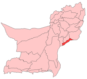 Map of Balochistan with Jafarabad District highlighted | |
| Country | Pakistan |
| Province | Balochistan |
| Established | 1987 |
| Headquarters | Dera Allah Yar/Usta Mohammad |
| Population | |
| • Total | 725,000 |
| Time zone | PST (UTC+5) |
| Website | Official site |
Jafarabad or Jaffarabad or Jaffar khan jamali (Balochi: جعفر آباد) district lies in the South-East of the Pakistani province of Balochistan. Jafarabad’s headquarters are at Dera Allah Yar. Formerly known as the Jhatpat subdivision, the region was part of the Jacobabad District until 1970 and part of the Sibi District until 1975. Thereafter, it became its own district.[1] Jaffarabad District is sub-divided into three tehsils. In the end of 15th century Jaffarabad was under of Lasharis. The main tribes of this district are Jamali, Gajani and Khoso tribes. Smaller communities are Gola, Umrani, Brohi and Soomro tribes.
Background
The district is named after Mir Jaffar Khan Jamali, a Muslim League veteran from Balochistan and a close friend of Quaid‑e‑Azam. He contributed towards the promotion of the Muslim League cause in the area. He died on April 7, 1967 and was buried in Rojhan Jamali. Before the creation of Jaffarabad District, during the “One‑Unit” period, this district was known as sub‑division Jhatpat and was a part of Jacobabad district of Sindh province. Jhatpat as a sub‑division is very old. It was raised to sub‑division level on 12 January 1932 with Captain Hoc Bland as the first Assistant Commissioner. On the dissolution of “One‑Unit” in 1970 it was included in Sibi district and remained within the jurisdiction of Sibi district till January 1975. In 1975, when Nasirabad district came into existence, Jhatpat was included in Nasirabad district. The Usta Mohammad sub‑division was a part of Sindh up to very recent years. Usta Mohammad is named after Maulvi Usta Mohammad. Chowki Jamali is a Famous Village of Jaffarabad. Jaffarabad is at a main‑road to Sindh province. Its boundaries link five districts: Larkarna, Jacobabad (Sindh), Nasirabad, Jhall Magsi, and Dera Bugti.
Administration
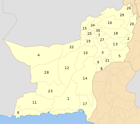
The district of Jaffarabad is administratively subdivided into the following three tehsils:[2]
- Gandakha
- Jhat Pat (Dera Allah Yar)
- Sohbat Pur
- Usta Mohammad
References
External links
| Wikimedia Commons has media related to Jafarabad District. |
Coordinates: 28°25′N 68°10′E / 28.417°N 68.167°E