Ivana, Batanes
| Ivana | ||
|---|---|---|
| Municipality | ||
|
| ||
| ||
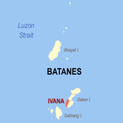 Location within Batanes province | ||
.svg.png) Ivana Location within the Philippines | ||
| Coordinates: 20°22′N 121°55′E / 20.37°N 121.92°ECoordinates: 20°22′N 121°55′E / 20.37°N 121.92°E | ||
| Country | Philippines | |
| Region | Cagayan Valley (Region II) | |
| Province | Batanes | |
| District | Lone District | |
| Barangays | 4 (see Barangays) | |
| Government [1] | ||
| • Type | Sangguniang Bayan | |
| • Mayor | Leonardo V. Hostallero | |
| Area[2] | ||
| • Total | 16.54 km2 (6.39 sq mi) | |
| Population (2015 census)[3] | ||
| • Total | 1,327 | |
| • Density | 80/km2 (210/sq mi) | |
| • Voter (2016)[4] | 993 | |
| Time zone | PST (UTC+8) | |
| ZIP code | 3902 | |
| IDD : area code | +63 (0)78 | |
| Income class | 6th class | |
| PSGC | 020903000 | |
| Website |
www | |

Ivana, officially the Municipality of Ivana (Filipino: Bayan ng Ivana), is a municipality in the province of Batanes in the Cagayan Valley (Region II) of the Philippines. The population was 1,327 at the 2015 census.[3] In the 2016 election, it had 993 registered voters.[4]
History
Ivana is one of the three major pueblos of Batanes in the first half of the 19th century, alongside Basco and Marigatao.[5] A mission was opened in the late 18th century with evangelization described as successful mainly due to the baptism of seven of the nine principals of Ivana.[6]
In 1789, Joaquin del Castillo became the third governor of Batanes. Measures were put in place to ensure that all the natives including unbaptized ones respect and obey the law by means of obedience to the governor as king's representative. An uprising ensued led by a certain "evil and lawless man" named Chivunao of Ivana, who persuaded his chiefs to rebel against the government. His failed attempt prompted him to organize an uprising in Itbud where the Spaniards' cannons forced the rebels to surrender.[6]
Geography
Ivana is located at 20°22′N 121°55′E / 20.37°N 121.92°E.
According to the Philippine Statistics Authority, the municipality has a land area of 16.54 square kilometres (6.39 sq mi)[2] constituting 7.55% of the 219.01-square-kilometre- (84.56 sq mi) total area of Batanes.
Barangays
Ivana is politically subdivided into 4 barangays.[7] San Vicente was elevated into a barrio in 1955.[8]
| PSGC | Barangay | Population | ±% p.a. | ||
|---|---|---|---|---|---|
| 2015[3] | 2010[9] | ||||
| 020903001 | Radiwan | 27.5% | 365 | 368 | −0.16% |
| 020903002 | Salagao | 26.3% | 349 | 319 | +1.73% |
| 020903003 | San Vicente (Igang) | 19.9% | 264 | 230 | +2.66% |
| 020903004 | Tuhel (Poblacion) | 26.3% | 349 | 332 | +0.96% |
| Total | 1,327 | 1,249 | +1.16% | ||
Demographics
| Population census of Ivana | |||||||||||||||||||||||||
|---|---|---|---|---|---|---|---|---|---|---|---|---|---|---|---|---|---|---|---|---|---|---|---|---|---|
|
| ||||||||||||||||||||||||
| Source: PSA[3][9][10] | |||||||||||||||||||||||||
In the 2015 census, Ivana had a population of 1,327.[3] The population density was 80 inhabitants per square kilometre (210/sq mi).
In the 2016 election, it had 993 registered voters.[4]
References
- ↑ "Municipality". Quezon City, Philippines: Department of the Interior and Local Government. Retrieved 31 May 2013.
- 1 2 "Province: Batanes". PSGC Interactive. Makati City, Philippines: Philippine Statistics Authority. Retrieved 23 November 2016.
- 1 2 3 4 5 "Region II (CAGAYAN VALLEY)". Census of Population (2015): Total Population by Province, City, Municipality and Barangay (Report). PSA. Retrieved 20 June 2016.
- 1 2 3 "2016 National and Local Elections Statistics". Commission on Elections. 2016.
- ↑ Mallat, J. (1846). "The Philippines: History, Geography, Customs, Agriculture, Industry and Commerce Colonies in Oceania" English Trans. Pura Santillan- Castrence. Manila: National Historical Institute
- 1 2 González Alonzo, Fr. Julio, O.P. (1966). "The Batanes Islands", in Acta Manilana, Manila: University of Santo Tomas Research Center
- ↑ "Municipal: Ivana, Batanes". PSA. Philippines: National Statistical Coordination Board. Retrieved 8 January 2016.
- ↑ "Republic Act No. 1331; An Act to Convert the Sitio of San Vicente in the Municipality of Ivana, Province of Batanes, into a Barrio to Be Known As the Barrio of San Vicente of Said Municipality". LawPH.com. Archived from the original on 3 May 2012. Retrieved 6 December 2016.
- 1 2 "Region II (CAGAYAN VALLEY)". Census of Population and Housing (2010): Total Population by Province, City, Municipality and Barangay (Report). NSO. Retrieved 29 June 2016.
- ↑ "Region II (CAGAYAN VALLEY)". Census of Population (1995, 2000 and 2007): Total Population by Province, City and Municipality (Report). NSO. Archived from the original on 24 June 2011.
External links
| Wikimedia Commons has media related to Ivana, Batanes. |
 |
Mahatao | | ||
| South China Sea | |
Uyugan | ||
| ||||
| | ||||
| Sabtang | Luzon Strait |