Iowa Highway 130
| ||||
|---|---|---|---|---|
 | ||||
| Route information | ||||
| Maintained by Iowa DOT | ||||
| Length: | 32.023 mi[1] (51.536 km) | |||
| Existed: | 1969 – present | |||
| Major junctions | ||||
| West end: |
| |||
| East end: |
| |||
| Location | ||||
| Counties: | ||||
| Highway system | ||||
| ||||

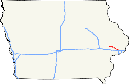
Iowa Highway 130 is a 32-mile (51 km) west–east state highway that traverses northwestern Scott County and eastern Cedar County in Iowa. Its western terminus is at Iowa Highway 38 in Tipton. Its eastern terminus is at Interstate 80 in Davenport.
Route description
Iowa Highway 130 begins in Tipton at an intersection with Iowa Highway 38. It proceeds eastward from Tipton and shortly before Bennett, it turns south to enter town. From Bennett, it goes east, turning southeast to go through New Liberty. It continues southeast through Plainview and Maysville and ends at exit 292 along Interstate 80 in Davenport.
History
Iowa Highway 130 was designated in 1969, along a section of Iowa Highway 150.[2] Until the mid-1970s, Highway 130 extended to US 61 / US 67 along the Davenport riverfront. By the 1980s, a portion of Harrison and Brady Streets had become one-way streets, joining near Vander Veer Park, leading to Iowa 130 to be truncated at the park.[3] When Welcome Way was completed in 1983 and southbound traffic was moved onto Harrison Street, Iowa 130 was truncated further back to Interstate 80.[4]
Major intersections
| County | Location | mi[1] | km | Destinations | Notes |
|---|---|---|---|---|---|
| Cedar | Tipton | 0.000 | 0.000 | Western terminus | |
| Scott | Davenport | 32.023 | 51.536 | Eastern terminus | |
| 1.000 mi = 1.609 km; 1.000 km = 0.621 mi | |||||
References
- 1 2 "2009 Volume of Traffic on the Primary Road System of Iowa" (PDF). Iowa Department of Transportation. January 1, 2009. Retrieved August 16, 2010.
- ↑ Iowa State Highway Map (PDF) (Map). Iowa State Highway Commission. 1969. Retrieved August 16, 2010.
- ↑ Iowa State Highway Map (PDF) (Map). Iowa Department of Transportation. 1981. Retrieved August 16, 2010.
- ↑ Iowa State Highway Map (PDF) (Map). Iowa Department of Transportation. 1983. Retrieved August 16, 2010.